
Page 28: of Marine Technology Magazine (November 2005)
Seafloor Engineering
Read this page in Pdf, Flash or Html5 edition of November 2005 Marine Technology Magazine
 27
27
 29
29
28 MTR November 2005
When Hurricane Katrina hit the mouth of the
Mississippi near New Orleans, the United States
Geological Survey (USGS) was asked to assess the damage to the barrier islands; the wetlands and the bird foot delta (mouth of the Mississippi). What USGS saw was remark- able and can be seen in the before and after shots shown on the opposite page.
The USGS used LIDAR Mapping data supplied by
NASA as well as aerial videos taken from the LIDAR air- craft. The information showed the decimation of the
Chandelier Islands, located immediately east of the delta. "We can define the health and stability of a barrier island by its length, width and height, and volume of sand com- prising the barriers. Before Katrina hit, the islands were in excellent health. Now they are about gone. The big ques- tion now is: what can be expected in terms of these islands re-forming. Will all the sand migrate back as has been seen in the past, or was the intensity of Katrina such that the sand has gone elsewhere for ever," said Jeff Williams, Sr. scientist, USGS, Woods Hole, Mass.
The USGS Coastal and Marine Geology team studies how the coast has evolved over time. The organization looks at barrier islands, beaches, rivers, lakes and wetlands and they make maps, lots of maps. USGS constantly updates its coastal and offshore atlas via annual surveys.
The USGS is constantly surveying the coastlines of the
U.S. Its mapping is part of a national research program to better understand changes to areas of the coast that are most vulnerable to storm damage and sea-level rise. Thus,
USGS, has a huge database of coastal features around the
U.S., including all along the Florida, Georgia, Louisiana,
Alabama, Texas coast lines in the Gulf of Mexico.
The USGS has been studying the degradation of the mouth of the Mississippi and the barrier islands and wet- lands that protect New Orleans for more than 20 years. It is a fact that New Orleans is sinking and sea level is rising.
Coupled with two 100-year storms such as Katrina and
Rita, the devastation we now see is not surprising.
According to Williams relative sea level is increasing at about one meter/100 years. At the same time the city of
New Orleans and its surrounding area is subsiding (sink- ing). The reason for the subsidence is due to a combina- tion of natural and man-made causes, such as 200 years of water being pumped out from under the city to keep daily flooding at bay and because of the gradual impact of all the oil and gas being pumped out from under the wet- lands and barrier islands.
Basically, the land on which New Orleans and its sur- rounding communities sits is like a big sponge that has had the moisture and air squeezed or sucked out of it, leaving it compacted. USGS and Army Corps of
Engineers data show that 80 percent of the area's "sink- ing" is due to subsidence from natural compaction as well as oil removal and 20 percent is due to global sea level rise.
According to USGS documents, sea level has been increas- ing for the past 20,000 years due to glaciers melting and the oceans warming. Lately it has, however increased due to warmer ocean water temperature. Warmer water expands and takes up more room, hence sea levels rise.
Williams and his colleagues have a huge data base and know a great deal about the geologic history and evolution of the delta plain, New Orleans and the surrounding marshes and barrier islands. Now they want to update that and re-survey the entire region and compare the after
Katrina and Rita storm data to prior to the storms. With that information they will be able to provide accurate information about where rebuilding would be most suc-
USGS
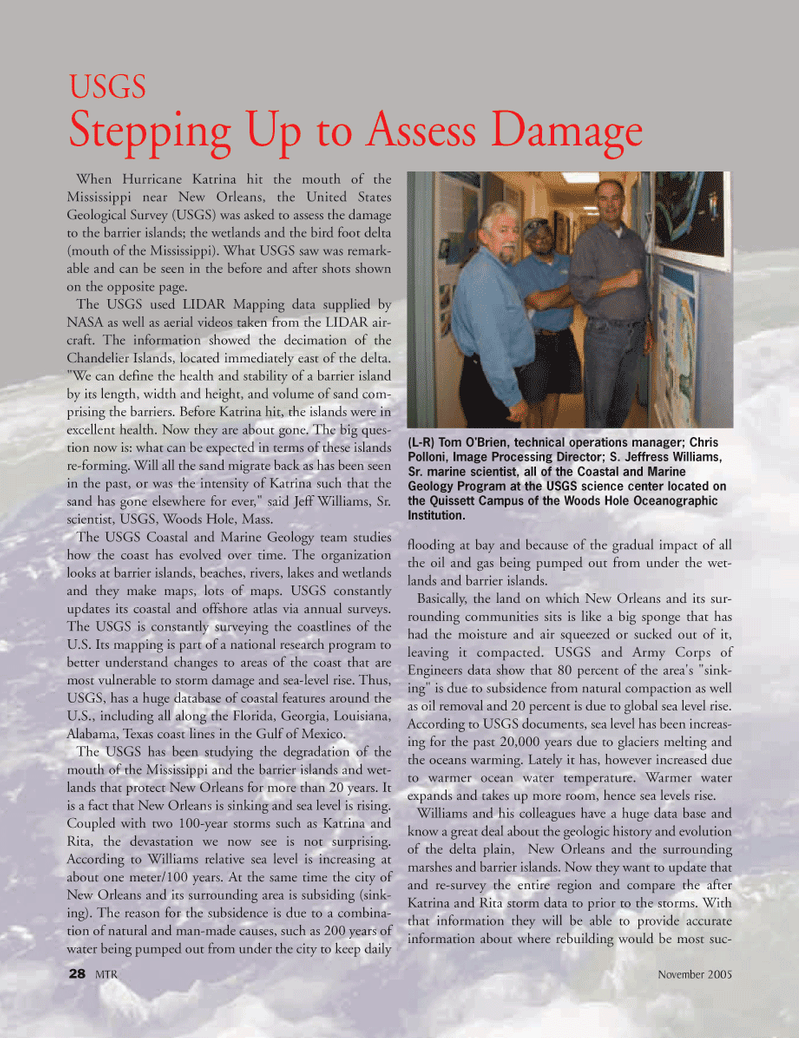
Stepping Up to Assess Damage (L-R) Tom O'Brien, technical operations manager; Chris
Polloni, Image Processing Director; S. Jeffress Williams,
Sr. marine scientist, all of the Coastal and Marine
Geology Program at the USGS science center located on the Quissett Campus of the Woods Hole Oceanographic
Institution.
MTR#3 (17-32).qxd 11/14/2005 1:01 PM Page 28