
Page 24: of Maritime Reporter Magazine (August 2013)
Shipyard Edition
Read this page in Pdf, Flash or Html5 edition of August 2013 Maritime Reporter Magazine
 23
23
 25
25
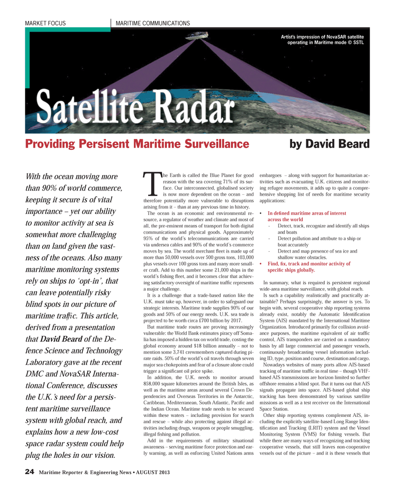
24 Maritime Reporter & Engineering News ? AUGUST 2013 MARKET FOCUS MARITIME COMMUNICATIONS The Earth is called the Blue Planet for good reason with the sea covering 71% of its sur- face. Our interconnected, globalised society is now more dependent on the ocean ? and therefore potentially more vulnerable to disruptions arising from it ? than at any previous time in history. The ocean is an economic and environmental re-source, a regulator of weather and climate and most of all, the pre-eminent means of transport for both digital communications and physical goods. Approximately 95% of the world?s telecommunications are carried via undersea cables and 90% of the world?s commerce moves by sea. The world merchant ß eet is made up of more than 50,000 vessels over 500 gross tons, 103,000 plus vessels over 100 gross tons and many more small-er craft. Add to this number some 21,000 ships in the world?s Þ shing ß eet, and it becomes clear that achiev-ing satisfactory oversight of maritime trafÞ c represents a major challenge.It is a challenge that a trade-based nation like the U.K. must take up, however, in order to safeguard our strategic interests. Maritime trade supplies 90% of our goods and 50% of our energy needs. U.K. sea trade is projected to be worth circa £700 billion by 2017. But maritime trade routes are proving increasingly vulnerable: the World Bank estimates piracy off Soma- lia has imposed a hidden tax on world trade, costing the global economy around $18 billion annually ? not to mention some 3,741 crewmembers captured during pi-rate raids. 50% of the world?s oil travels through seven major sea chokepoints and fear of a closure alone could trigger a signiÞ cant oil price spike. In addition, the U.K. needs to monitor around 858,000 square kilometres around the British Isles, as well as the maritime areas around several Crown De-pendencies and Overseas Territories in the Antarctic, Caribbean, Mediterranean, South Atlantic, Paci Þ c and the Indian Ocean. Maritime trade needs to be secured within these waters ? including provision for search and rescue ? while also protecting against illegal ac-tivities including drugs, weapons or people smuggling, illegal Þ shing and pollution. Add in the requirements of military situational awareness ? serving maritime force protection and ear- ly warning, as well as enforcing United Nations arms embargoes ? along with support for humanitarian ac- tivities such as evacuating U.K. citizens and monitor- ing refugee movements, it adds up to quite a compre-hensive shopping list of needs for maritime security applications:? In deÞ ned maritime areas of interest across the world - Detect, track, recognize and identify all ships and boats - Detect pollution and attribute to a ship or boat accurately - Detect and map presence of sea ice and shallow water obstacles. ? Find, Þ x, track and monitor activity of speciÞ c ships globally. In summary, what is required is persistent regional wide-area maritime surveillance, with global reach.Is such a capability realistically and practically at-tainable? Perhaps surprisingly, the answer is yes. To begin with, several cooperative ship reporting systems already exist, notably the Automatic Identi Þ cation System (AIS) mandated by the International Maritime Organization. Introduced primarily for collision avoid- ance purposes, the maritime equivalent of air trafÞ c control, AIS transponders are carried on a mandatory basis by all large commercial and passenger vessels, continuously broadcasting vessel information includ-ing ID, type, position and course, destination and cargo. Nowadays websites of many ports allow AIS-based tracking of maritime trafÞ c in real time ? though VHF- based AIS transmissions are horizon limited so further offshore remains a blind spot. But it turns out that AIS signals propagate into space. AIS-based global ship tracking has been demonstrated by various satellite missions as well as a test receiver on the International Space Station. Other ship reporting systems complement AIS, in- cluding the explicitly satellite-based Long Range Iden-tiÞ cation and Tracking (LRIT) system and the Vessel Monitoring System (VMS) for Þ shing vessels. But while there are many ways of recognizing and tracking cooperative vessels, that still leaves non-cooperative vessels out of the picture ? and it is these vessels that Satellite Radar Satellite Radar Providing Persisent Maritime Surveillance by David Beard With the ocean moving more than 90% of world commerce, keeping it secure is of vital importance ? yet our ability to monitor activity at sea is somewhat more challenging than on land given the vast-ness of the oceans. Also many maritime monitoring systems rely on ships to ?opt-in?, that can leave potentially risky blind spots in our picture of maritime trafÞ c. This article, derived from a presentation that David Beard of the De-fence Science and Technology Laboratory gave at the recent DMC and NovaSAR Interna-tional Conference, discusses the U.K.?s need for a persis- tent maritime surveillance system with global reach, and explains how a new low-cost space radar system could help plug the holes in our vision.Artist?s impression of NovaSAR satellite operating in Maritime mode © SSTLMR #8 (18-25).indd 24MR #8 (18-25).indd 248/1/2013 9:19:12 AM8/1/2013 9:19:12 AM
