Acoustic Tracking Devices
-
- D-Day Mapping Mission Marine Technology, Mar 2014 #56
It’s been almost 70 years since the invasion of Normandy, France when 156,000 Allied troops landed and began their march across Europe to defeat Hitler. And, while these soldiers’ collective destinies could not have been known at the time, their will to fight was unmistakable. General Dwight D. Eisenhower called the D-Day operation a crusade in which “we will accept nothing less than full victory.” The allied troops heard this charge and proved their resolve. The D-Day cost was high — more than 9,000 Allied soldiers were killed or wounded — but on Tuesday, June 6, 1944 more than 100,000 soldiers gained a crucial foothold in Normandy. (Source: D-Day - June 6, 1944 - the United States Army).
On D-Day and the days following, a 50-mile stretch of French coastline was overtaken by man and machine. In total there were 170,000 vehicles and 5,000-plus ships, including 702 war ships. The beaches of Normandy no doubt have a story to tell.
To honor those who served, a massive survey and archeological effort is underway sponsored by France Televisions, 13 other broadcasters and the Normandy region. The French Navy (Marine National) and Department of Underwater and Undersea Archeological Research (DRASSM) were involved as well. Involvement from Sherrell Ocean Services, Trimble Navigation, Ltd. and Measutronics Corporation, a Trimble authorized marine dealer, was also instrumental in making this expedition possible. Each company involved is committed to the effort and is graciously donating their time, equipment and expertise to the project. Covering approximately 500 square kilometers, this will be the largest continuous survey of this type ever completed in the region. Together, these groups are building a complete GIS database of the area based around the five invasion beaches of D-Day. The volunteers are sharing their professional expertise to preserve the Normandy beaches’ history as well as capture 3D images of the historic assets.
Through their survey and mapping work, the team is working to have the Normandy D-Day invasion coastline designated as a UNESCO World Heritage Site by the World Heritage Committee. A UNESCO World Heritage Site is a location that is identified as having special cultural or physical significance, not to a single nation, but to the world.
Beaches of Normandy - Survey
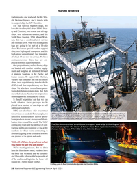
The Discovery Phase of the mapping expedition started in July 2013 with a catamaran and crew leaving from Port of Saint-Malo, France. The total survey effort took nearly seven weeks and involved bathymetric mapping with an EdgeTech interferometric multibeam / side scan sonar combined with the Trimble SPS855/555H GNSS modular heading bundle and an inertial motion reference unit (MRU). The Trimble SPS heading bundle outputs the position, heading and timing synchronization data to the multibeam data collection and processing software. Here it is stored and time-tagged to the sonar data. Geo-referenced point cloud and side scan data are displayed real time for review by the system operator as well as logged for further data editing, processing and mapping.
The Trimble SPS series heading bundle antenna array was mounted on center with the transducer mount pole near the bow of the catamaran vessel. A custom mount was developed and built to allow the entire survey sensor package to be retracted when entering or departing local ports, which have limited hull clearances, dependent upon tides. The interferometric sonar system afforded wide swath “point cloud” coverage for three-dimensional modeling and also provided side scan planimetric imagery to aid in target identification.
Measutronics Corporation, Trimble’s leading U.S. Marine dealer, was chosen for this project because of its experience in the field of marine guidance, mapping, imaging and equipment holdings. Lou Nash, Measutronic’s founder, explains that the GNSS heading bundle is critical to the bathymetric systems because, “without accurate positioning, you essentially don’t have a reference point or know where you are in relation to anything else; as a result you can’t accurately and efficiently trace back to targets in the water. In addition, the ‘motion of the ocean’ must be accounted for as all the sounding and image data collected are done so from a constantly moving platform – subject to the effects of vessel heave, pitch and roll.”
The Trimble SPS855 site positioning heading bundle was selected because of its accuracy and it’s interoperability with Fugro Marinestar satellite-based correction signals as well as shore-based reference stations. The SPS series heading bundle is also interoperable with a number of motion reference units (MRU). With inputs from the heading bundle receivers, the MRU provided a blended GNSS / inertial solution, compensating for the effects of heave, pitch and roll. The Marinestar correction service was chosen over land-based correction transmission stations as typical UHF radio transmission would have required increased logistics and would not have provided adequate coverage for a large portion of the offshore due to the extreme distances involved.
“We chose the Trimble receiver because it’s really the only modular receiver that delivers the flexibility, accuracy and performance that we needed on a marine mapping expedition as significant as this,” said Nash. “It tracks the full GNSS constellation, giving better positioning availability and high precision, plus our crew knows the equipment inside and out.”
Target Identification Phase
In mid-August the crew began to focus on further development of targets of interest identified during the previous weeks of surveying. Now mobilizing from Cherbourg, France, efforts included the use of SeaBotix remotely operated vehicles (ROVs) fitted with Tritech acoustic tracking devices and sonar. These efforts were used to prioritize those targets to be further developed / examined with a higher resolution multibeam sonar system. For the remainder of the survey, crews use the SeaBotix ROVs and a video camera along while continuing to collect multibeam data.
High-Interest Targets
For high resolution point cloud data collection, an R2Sonic 2024 Ultra High Resolution (UHR) mulitibeam sonar was used. With the ultra-high resolution sonar system, the crew collected high-resolution point cloud data for about 20 historic assets of particular interest.
As a further effort in providing the most accurate point cloud data possible, GNSS phase data and inertial data were collected and logged with an Applanix POS MV motion reference unit. Data were then post processed with Applanix’s POSPac MMS software providing a “true heave” blended GNSS / inertial solution. The post processed data files were then read into a hydrographic survey software package. Martin de Kievit, business development manager for Trimble Marine in the Heavy Civil Construction division, explains that the survey software grabs input from the GNSS receiver where it allows for display and editing of track lines, sounding profiles and text data. The software system correlates time-tagged tide, vessel position, motion and sound velocity correction data which are used to accurately plot and record locations.
“Our surveys reported some 300 targets [artifacts] and about 20 ‘new’ wreckage sites were more fully developed,” said Nash.
As submerged targets of interest were more fully developed and accurately located, crews also launched small manned submarines to capture film footage of various high-profile wreckage sites. Led by Andy Sherrell of Sherrell Ocean Services, the crew filmed sites in order to capture color and details of what the servicemen may have faced on that fateful June day. Using video, sonar, 3D imagery and 3D visualizations, the crew is essentially “peeling back the water to bring these stories to life,” Nash added.
With higher resolution images and precise point cloud data, the crew is hoping to determine the actual ship, aircraft or vehicle name of the artifacts revealed. With this information, historians will also endeavor to derive names, ranks and associations of the crewmembers that were aboard the vessels or vehicles when they were sunk and destroyed.
Updating the GIS Database
During the months to come, teams will continue to work with the massive 11TB data set. The United Kingdom Hydrographic Office (UKHO) and the French nautical charting authority (SHOM) are collaborating in an effort to update the international wreck database for the area. Because a large percentage of these identified artifacts are newly discovered or were inaccurately positioned previously, the team is working to make these corrections before they deliver the complete survey data to the UNESCO World Heritage Committee for review. To commemorate the event, MC4 and LCL Production are producing a 90-minute documentary for the international market. PBS/Nova will broadcast an adaptation in North America, both to be aired memorializing the 70th anniversary.
Honoring Those Who Were There on “The Longest Day”
During the official 70th Anniversary D-Day ceremony scheduled for June 2014, veterans, dignitaries and archeologists will meet along this historic coast to honor those who have served and sacrificed. Led by the French Department of Underwater Archeological Research, manned submarines will also escort a handful of WWII veterans and historians underwater to investigate a few of the high-profile identified wrecks.
“Nearly everyone we approached about providing support for this historic mapping expedition, by means of donating equipment or personnel, was extremely supportive and enthusiastic about the project,” said Nash. “Everyone has considered it an honor to be involved in this effort, and I know I feel that way, as do our guys.”
(As published in the March 2014 edition of Marine Technology Reporter - www.seadiscovery.com)
-
 )
March 2024 - Marine Technology Reporter page: 45
)
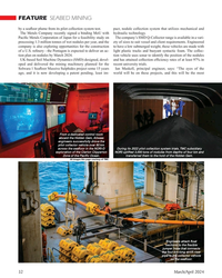
March 2024 - Marine Technology Reporter page: 45Group signed a contract with Kongsberg Discovery Unique Group signed a contract with Kongsberg Discov- ery for $1.7m of seabed mapping and compact acoustic po- sitioning technology for the APAC region. The agreement, Ocean Lander for the delivery of cNODE Transponders, µPAP SSBL COMPONENTS AND SYSTEMS syste
-
 )
March 2024 - Marine Technology Reporter page: 40
)
March 2024 - Marine Technology Reporter page: 40payloads such as deep-water Multibeam Echosound- The new DriX O-16 bene? ts from a hybrid propulsion, redun- ers (MBES), Sub-Bottom Pro? lers (SBP), or acoustic subsea dant architecture, advanced communication systems, as well positioning and communication systems (USBL). 40 March/April 2024 MTR #3 (34-47)
-
 )
March 2024 - Marine Technology Reporter page: 32
)
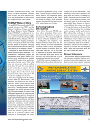
March 2024 - Marine Technology Reporter page: 32FEATURE SEABED MINING by a sea? oor plume from its pilot collection system test. pact, nodule collection system that utilizes mechanical and The Metals Company recently signed a binding MoU with hydraulic technology. Paci? c Metals Corporation of Japan for a feasibility study on The company’s SMD
-
 )
March 2024 - Marine Technology Reporter page: 30
)
March 2024 - Marine Technology Reporter page: 30FEATURE SEABED MINING bilical. It has passive heave compensation which nulli? es the necott. “The focus since then has been on scaling while en- wave, current and vessel motions that in? uence loads in the suring the lightest environmental impact,” says The Metals power umbilical. The LARS can
-
 )
March 2024 - Marine Technology Reporter page: 25
)
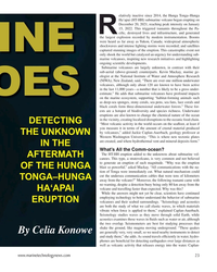
March 2024 - Marine Technology Reporter page: 25board included a deep- cano in the Tonga arc. “We’ve seen a ton per water column near the site.” towed imaging system, multicorer, CTD of landslides in acoustic data recorded (conductivity, temperature, depth), and off Kilauea and West Mata. Before that Known Unknowns autonomous ocean glider. Mackay’s fa-
-
 )
March 2024 - Marine Technology Reporter page: 23
)
March 2024 - Marine Technology Reporter page: 23have continued employing technology to better understand the behavior of submarine ERUPTION volcanoes and their seabed surroundings. “Seismology and acoustics are both the study of what we call elastic waves, in which materials vibrate when force is applied to them,” explained Caplan-Auerbach. Seismology
-
 )
March 2024 - Marine Technology Reporter page: 15
)
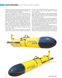
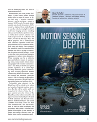
March 2024 - Marine Technology Reporter page: 15conservation, Shea Quinn is the Product Line Manager the Sentinel can run several high-energy passive and active of the Slocum Glider at Teledyne Webb acoustic sensors, on-board processing, and imaging hardware Research. Quinn came to Teledyne Webb Research from Lockheed Martin. He simultaneously for months
-
 )
March 2024 - Marine Technology Reporter page: 14
)
March 2024 - Marine Technology Reporter page: 14length to over 2 years; or users can ? t more ? ight control, and communications architecture of the Slocum high-energy sensors like active or passive acoustics, sensors Glider, and allows for the same sensor and hardware options with on-board processing, and imaging, without seeing a sig- as the standard-sized
-
 )
March 2024 - Marine Technology Reporter page: 11
)
March 2024 - Marine Technology Reporter page: 11Strikepod Systems, a research and strategic advisory mines utilize a range of sensors to de- focusing on autonomous undersea systems. tect their prey – acoustic, magnetic, pressure – and as such pose a hazard to manned MCM vessels. To safely detect, identify, and classify these mines, AUVs would be deployed
-
 )
March 2024 - Marine Technology Reporter page: 2nd Cover
)
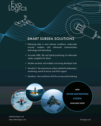
March 2024 - Marine Technology Reporter page: 2nd CoverSMART SUBSEA SOLUTIONS • Delivering data in most adverse conditions: underwater acoustic modems with advanced communication technology and networking • Accurate USBL, LBL and hybrid positioning of underwater assets, navigation for divers • Modem emulator and multiple cost-saving developer tools • Sonobot
-
 )
April 2024 - Maritime Reporter and Engineering News page: 43
)
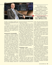
April 2024 - Maritime Reporter and Engineering News page: 43“The industry is an ecosystem which includes owners, managers, mariners, shipyards, equipment makers, designers, research institutes and class societies: all of them are crucial,” – Eero Lehtovaara, Head of Regulatory & Public Affairs, ABB Marine & Ports All images courtesy ABB Marine and Ports provi
-
 )
April 2024 - Maritime Reporter and Engineering News page: 40
)
April 2024 - Maritime Reporter and Engineering News page: 40TECH FEATURE SITUATIONAL AWARENESS SITUATIONAL AWARENESS SYSTEM BATTLES COGNITIVE FATIGUE IN WATCHKEEPERS All images courtesy Groke Technologies Today’s evolving maritime security risks pose all-too-familiar threats to international shipping, and as just one of the many causes of fatigue, they add
-
 )
April 2024 - Maritime Reporter and Engineering News page: 34
)
April 2024 - Maritime Reporter and Engineering News page: 34FEATURE Image courtesy Kongsberg Digital Simulators Track our Changing Relationship with Technology Simulation-based training has its whole-of-ship/ whole-of-team scenarios, but zooming in, the industry is now working on more speci? c targets. By Wendy Laursen Image above: Kongsberg Digital has integrated
-
 )
April 2024 - Maritime Reporter and Engineering News page: 28
)
April 2024 - Maritime Reporter and Engineering News page: 28FEATURE INTERVIEW track missiles and warheads for the Mis- sile Defense Agency, and it travels with its support ship, the MV Hercules. For our Service Support ships, we have the two hospital ships, USNS Mer- cy and Comfort; two rescue and salvage ships; two submarine tenders; and the Sixth Fleet ?
-
 )
April 2024 - Maritime Reporter and Engineering News page: 27
)
April 2024 - Maritime Reporter and Engineering News page: 27partners, but we’re also competing veillance with their towed arrays, and one is a contract vessel, with them for talent. HOS Red Rock, that can conduct acoustic monitors 24/7 for The U.S. Merchant Marine Academy and state maritime months at a time. We have six T-AGS oceanographic survey academies are graduating
-
 )
April 2024 - Maritime Reporter and Engineering News page: 15
)
April 2024 - Maritime Reporter and Engineering News page: 15hydro-acoustic design of a propulsor that delays cavitation meets its underwater noise limits. This will require specialized inception and cavitating area. The third approach should be test sites or specialized mobile underwater testing equipment. isolation mounting of a vibro-active equipment and
-
 )
April 2024 - Maritime Reporter and Engineering News page: 14
)
April 2024 - Maritime Reporter and Engineering News page: 14type (FEA). The most accurate are those that can account for all and function of the vessel. The limits should be achievable the machinery transmitting acoustic energy over all the pos- and reasonable from an overall systems viewpoint. Above all sible structural and airborne paths into the ocean. The hydro- they
-
 )
April 2024 - Maritime Reporter and Engineering News page: 13
)
April 2024 - Maritime Reporter and Engineering News page: 13from gasoline to methanol, but compared to just buying an EV After some pondering, I think I can reduce it to this logi- today that is a pointless exercise. It would actually make more cal sequence: sense to buy a plug-in hybrid that is con? gured for methanol It is the carbon. We want zero carbon as
-
 )
April 2024 - Marine News page: 24
)
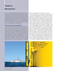
April 2024 - Marine News page: 24Feature Navigation cables, 9 miles of cables connecting substations and up to blurred, undependable information for vessel crews. two export transmission cables with “associated secondary In the fairways Notice, the USCG references the NAS cable protection” (text is from the permit) within a 42-mile-
-
 )
April 2024 - Marine News page: 21
)
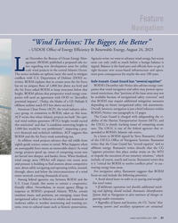
April 2024 - Marine News page: 21Feature Navigation “Wind Turbines: The Bigger, the Better” – USDOE Of? ce of Energy Ef? ciency & Renewable Energy, August 24, 2023 ast December the Bureau of Ocean Energy Man- Agencies write: we want to advance wind energy, but ocean agement (BOEM) published a proposed sale no- areas can only yield so
-
 )
February 2024 - Maritime Reporter and Engineering News page: 32
)
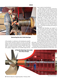
February 2024 - Maritime Reporter and Engineering News page: 32REPAIR Photo Courtesy Marine and Industrial Transmissions ings to optimize load distribution. A large number of the incidents analyzed by Gard were attributed to ghost ? shing gear that enter the stern tube seal area causing seawater to contaminate the lubrication oil. A 2022 study by CSIRO scientists
-
 )
February 2024 - Maritime Reporter and Engineering News page: 3
)
February 2024 - Maritime Reporter and Engineering News page: 3When You’re Serious Pure Radar The most dependable collision avoidance in any weather condition... day or night! Award-Winning NXT & X-Class FR10 & FR12 Radar Domes & Open Arrays 10.4” & 12.1” Color LCD Radar Displays Safely navigate high-traffic areas with complete confidence. Target Analyzer™ alerts you
-
 )
February 2024 - Marine News page: 27
)
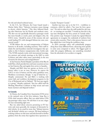
February 2024 - Marine News page: 27Feature Passenger Vessel Safety ? re risk and related technical issues. Canada: Transport Canada.” In the U.S., last February, the Coast Guard issued a Another top issue, just as in the U.S. – workforce re- Marine Safety Alert: “Saltwater intrusion causes damage cruitment, which he called a “key issue for
-
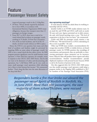 )
February 2024 - Marine News page: 24
)
February 2024 - Marine News page: 24Feature Passenger Vessel Safety Any upcoming meetings? inspected passenger vessels in the U.S-? ag ? eet. • Of these, 530 are already required by domestic In early January, NTSB was asked about its working re- law to have SMSs, in accordance with lationship with the USCG. International Maritime