Data Communications
-
- Maritime Satellites Now Reach 2,000 Users Maritime Reporter, Nov 1983 #89
The Sedco 602, an offshore drilling rig, now in Singapore, has become the 2,000th user equipped for maritime satellite communications.
With its newly installed ship earth station, the rig has access to the international maritime satellite system operated by INMARSAT, which provides the satellite capacity for telephone, telex, facsimile and data communications to the worldwide shipping and offshore industries.
The Sedco 602 is a new rig, built in Singapore, which is owned by a joint partnership between Sedco, Inc. and Occidental Petroleum. The rig will be going to the Philippines and later to China for offshore exploration work. The satellite terminal is to be used for telephone and data communications.
With 39 member countries, the International Maritime Satellite Organization (INMARSAT) has a wide range of users including oil tankers, offshore drilling rigs, passenger liners, cargo and container vessels, yachts and fishing boats, as well as research bases in Antarctica and production platforms in the North Sea.
-
- Talon Technology To Provide Satellite Communications Systems Maritime Reporter, Mar 1983 #65
Talon Technology Corporation, Richardson, Texas, was organized recently to provide mobile satellite data communications systems and consulting services to the petroleum, marine, and defense industries. Lynn B. Heitman is president of the new company, whose corporate headquarters are at 1819 Firman
-
- 1981 RTCM ASSEMBLY Maritime Reporter, Apr 15, 1981 #6
ship-ship alerting and is expected to be fully operational in 1990 or shortly thereafter. Many details remain to be developed. "Preparing for Data Communications on Marine Satellite/VHF Radio/Sitor" by R.G. Bunce, Maritel, Inc. Synopsis—At present there is an explosion of development in data communicatio
-
- GPS Plots The Future Of Navigation & Communications Maritime Reporter, Mar 1992 #57
signals and derive precise position information. The Inmarsat-A system permits global two-way telephone, facsimile, telex, E-mail and data communications. Users will be able to employ their terminals for other telephone and data communications, even while receiving this point-tomultipoint service
-
- Navy Extends Use Of MARISAT Satellite Service An Additional Year Maritime Reporter, Nov 1981 #100
for the commercial shipping and offshore industries. Services to the international maritime market include telephone, telex, facsimile, and data communications
-
- Singapore Buys $12 Million VTS From Norcontrol Maritime Reporter, Jul 1992 #54
radio data terminals. Norcontrol will design, supply and install the company's VOC 5000 work stations, radar and tracking system, radio and data communications and Port Traffic Management System for the Port of Singapore. For additional information about Norcontrol's VTS equipment line and services
-
- Rockwell-Collins Awarded Contract To Supply Data Links For Spanish Navy Maritime Reporter, Jul 15, 1986 #62
technology, and are NATO-compatible, having previously been deployed by five other NATO navies. Link 11 is a long-range, digital data communications network connecting widely spaced elements of a task force. It provides technical data exchange among surface vessels, shore stations, and
-
- SHIPBOARD COMPUTER SURVEY Maritime Reporter, Dec 1985 #58
PC/XT with 10MB hard disk and cassette back-up, a monochrome monitor, a high-speed dot-matrix printer with graphics capability and a modem for data communications. A similar computer, without the shipboard ruggedization, can be used in the shoreside office, and extensive capabilities have been built
-
- COMPUTERIZED VESSEL MANAGEMENT SYSTEMS Maritime Reporter, Jan 15, 1985 #14
, test, and market a Sale and Purchase database. The MARDATA Library Interface (MLI) is a powerful software package that combines sophisticated data communications with new automated features for on-line database access, reducing many complicated and time-consuming access and search procedures into simple
-
- Sperry Introduces A d v a n c ed S a t e l l i t e Communicators Maritime Reporter, Jul 15, 1986 #38
all these features and can interface with facsimile machines, onboard computers, remote telephones, vessel PBXs, and the Sperry Integrated Data Communications System which includes the Starbaud module for high speed, 2400-baud transmission of reports, lisings or charts. The MCS2B operates similarly
-
- TeleSystems Introduces Advanced Transportable Satellite Earth Station Maritime Reporter, Apr 1985 #102
response t63IHS Through the INMARSAT network of communications satellites, the TCS-9000 provides long-distance telephone service, telex, and data communications from anywhere in the world. The entire system weighs just 70 pounds, is packaged in two weathertight aluminum carrying cases, uses only
-
- TeleSystems' Compact Communications Unit Approved Maritime Reporter, Nov 1985 #98
system is small (110 pounds) and rugged enough to be carried as luggage, with full capabilities to provide long-distance telephone, telex, and data communications from anywhere in the world. Located in Northern Virginia, COMSAT TeleSystems, Inc. designs, manufactures, markets and provides worldwide
-
 )
March 2024 - Marine Technology Reporter page: 45
)
March 2024 - Marine Technology Reporter page: 45ronments. The new agreement will address speci? c techni- cal gaps in the UUV defense and offshore energy markets especially for long duration, multi-payload mission opera- tions where communications are often denied or restricted. As part of the new alliance, Metron’s Resilient Mission Autonomy portfolio
-
 )
March 2024 - Marine Technology Reporter page: 43
)
March 2024 - Marine Technology Reporter page: 43windfarms. GeoPulse 2 introduces new capa- for any dedicated transducers or cabinet of electronics. That bilities that enhance both its operation and data quality. means no additional hardware beyond what is used for the The system is a drop-in replacement for the GeoPulse Pinger EM 124 or EM 304 MBES
-
 )
March 2024 - Marine Technology Reporter page: 41
)
March 2024 - Marine Technology Reporter page: 41Helmholtz Association’s MO- SES initiative, focuses on monitoring ocean eddies. These ve- hicles are equipped with sensors for collecting geo-referenced data on various physical water parameters, including tempera- ture, pressure, oxygen, conductivity, and ? uorescence, at dif- ferent depth levels. Building
-
 )
March 2024 - Marine Technology Reporter page: 40
)
March 2024 - Marine Technology Reporter page: 40NEW TECH OCEANOLOGY INTERNATIONAL 2024 All photos courtesy MTR unless otherwise noted NEW TECH, PARTNERSHIPS LAUNCH IN LONDON With Oceanology International now one month in the rear-view mirror, MTR takes a look at some of the interesting technologies launched before, during and after the London event.
-
 )
March 2024 - Marine Technology Reporter page: 39
)
March 2024 - Marine Technology Reporter page: 39before selecting one for critical use. Testing must replicate the expected ? eld conditions, espe- cially temperature and current drain. Use your own data to drive your decision. FURTHER READING Landereans are encouraged to follow their curiosity into this hugely fascinating ? eld. There are many good
-
 )
March 2024 - Marine Technology Reporter page: 34
)
March 2024 - Marine Technology Reporter page: 34will be depleted faster due to in- its capacity times its average potential. A battery pack is the creased internal resistance. Consult the manufacturer’s data- assembly of batteries in series, to increase voltage, in parallel, sheet for the discharge graphs. to increase current capacity, or both. Many batteries
-
 )
March 2024 - Marine Technology Reporter page: 30
)
March 2024 - Marine Technology Reporter page: 30subsea, nodules have helped further advance the design. and the LARS is ? tted with a routing system that keeps the Digital twin technology analyzes data gathered from mul- umbilical in a single plane during collector operations. tiple sensors and assets to enable 3D visualization of op- The collector’s
-
 )
March 2024 - Marine Technology Reporter page: 27
)
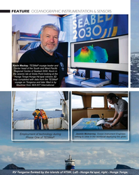
March 2024 - Marine Technology Reporter page: 27SEA-KIT USV Maxlimer returning from HT-HH caldera in Tonga. © SEA-KIT International data and further assess ecosystem recov- ery. What is known, noted Caplan-Auer- bach, is that the impact of submarine vol- canoes on humans is rare. “The HT-HH eruption was a tragedy, but it was very unusual. It let us
-
 )
March 2024 - Marine Technology Reporter page: 26
)
March 2024 - Marine Technology Reporter page: 26Paci? c Regional Centre of Seabed 2030. Kevin in the seismic lab at Greta Point looking at the Hunga Tonga-Hunga Ha’apai volcano 3D map completed with data from the TESMaP voyage on Tongaroa and later ? lled in by Maxlimer from SEA-KIT International. Jasmin McInerney, Ocean Instrument Engineer, Employment
-
 )
March 2024 - Marine Technology Reporter page: 25
)
March 2024 - Marine Technology Reporter page: 25baseline for monitoring future recovery. wider Paci? c Ocean. Mackay, who spe- to detect submarine landslides as well “Preliminary water column data from cializes in sea? oor mapping techniques, as earthquakes and eruptions,” said Maxlimer show airborne ash that had served as voyage lead. Phase
-
 )
March 2024 - Marine Technology Reporter page: 23
)
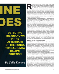
March 2024 - Marine Technology Reporter page: 23elatively inactive since 2014, the Hunga Tonga–Hunga Ha‘apai (HT-HH) submarine volcano began erupting on December 20, 2021, reaching peak intensity on January 15, 2022. This triggered tsunamis throughout the Pa- R ci? c, destroyed lives and infrastructure, and generated the largest explosion recorded
-
 )
March 2024 - Marine Technology Reporter page: 22
)
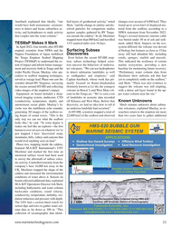
March 2024 - Marine Technology Reporter page: 22FEATURE OCEANOGRAPHIC INSTRUMENTATION & SENSORS Aerial view of HT-HH volcano, showing new multibeam depth data overlaid on islands satellite image. © SEA-KIT, NIWA-Nippon Foundation TESMaP 22 March/April 2024 MTR #3 (18-33).indd 22 4/4/2024 9:08:10 AM
-
 )
March 2024 - Marine Technology Reporter page: 19
)
March 2024 - Marine Technology Reporter page: 19information obtained project management, inspection, over a relatively limited extent of time. Also, because FiGS sales, marketing and management in data is combined with detailed CP models developed using the sector since 2001. FORCE Technology’s SeaCorrTM software, it’s possible to easily identify
-
 )
March 2024 - Marine Technology Reporter page: 18
)
March 2024 - Marine Technology Reporter page: 18mechanism enables the sensor to ducing maintenance costs. determine the direction of the electric ? eld. This directional The system can also collect data faster than other measure- insight not only provides a relative positioning for the ? nd- ment methods. A FiGS pipeline survey can be conducted with
-
 )
March 2024 - Marine Technology Reporter page: 17
)
March 2024 - Marine Technology Reporter page: 17of • Mitigation, intervention and repair. sacri? cial anodes, this can be dif? cult or even impossible to Selecting the best method for collecting the data these work- estimate due to poor visibility, the presence of marine growth streams demand can have implications across the board, from and/or corrosion
-
 )
March 2024 - Marine Technology Reporter page: 14
)
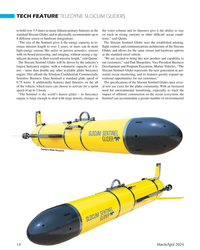
March 2024 - Marine Technology Reporter page: 14in per- engine. This affords the Teledyne Con? dential; Commercially sistent ocean monitoring, and its features greatly expand op- Sensitive Business Data Sentinel a standard glide speed of erational opportunities for our customers.” 0.75 knots. It additionally features dual thrusters on the aft The
-
 )
March 2024 - Marine Technology Reporter page: 13
)
March 2024 - Marine Technology Reporter page: 13, physical oceanography, defense, or dozens of other missions – has driven advance- ments in glider technology to meet the modern demand for long-term data gathering of all kinds. In response, Teledyne Webb Research has announced the launch of their new- est product in the ? eld of buoyancy engine driven
-
 )
March 2024 - Marine Technology Reporter page: 6
)
March 2024 - Marine Technology Reporter page: 6MTR Editorial Advisors Gallaudet Hardy The Honorable Tim Gallaudet, Kevin Hardy is President PhD, Rear Admiral, U.S. of Global Ocean Design, Navy (ret) is the CEO of creating components and Ocean STL Consulting and subsystems for unmanned host of The American Blue vehicles, following a career
-
 )
March 2024 - Marine Technology Reporter page: 2nd Cover
)
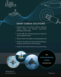
March 2024 - Marine Technology Reporter page: 2nd CoverSMART SUBSEA SOLUTIONS • Delivering data in most adverse conditions: underwater acoustic modems with advanced communication technology and networking • Accurate USBL, LBL and hybrid positioning of underwater assets, navigation for divers • Modem emulator and multiple cost-saving developer tools • Sonobot
-
 )
April 2024 - Maritime Reporter and Engineering News page: 43
)
April 2024 - Maritime Reporter and Engineering News page: 43leading class societies, Lehtovaara sions trading – are optimized by formaliz- Lehtovaara suggests. started the International Council on ing solutions for data sharing. Lehtovaara “As [IMO Secretary General] Arsenio Combustion Engines (CIMAC) Indus- says regulators should reconceive the Dominguez said recently
-
 )
April 2024 - Maritime Reporter and Engineering News page: 41
)
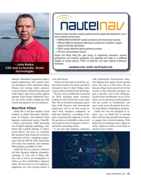
April 2024 - Maritime Reporter and Engineering News page: 41Nautel provides innovative, industry-leading solutions speci? cally designed for use in harsh maritime environments: • GMDSS/NAVTEX/NAVDAT coastal surveillance and transmission systems • Offshore NDB non-directional radio beacon systems for oil platform, support vessel & wind farm applications
-
 )
April 2024 - Maritime Reporter and Engineering News page: 40
)
April 2024 - Maritime Reporter and Engineering News page: 40perform adminis- era, as well as radar and AIS. An inbuilt inertial measurement L trative tasks while on the bridge, port turnaround times unit collects data on pitch, roll, and yaw, and a high-precision are short, and there’s more technology onboard to master. GNSS provides positioning data. The resulting
-
 )
April 2024 - Maritime Reporter and Engineering News page: 28
)
April 2024 - Maritime Reporter and Engineering News page: 28FEATURE INTERVIEW track missiles and warheads for the Mis- sile Defense Agency, and it travels with its support ship, the MV Hercules. For our Service Support ships, we have the two hospital ships, USNS Mer- cy and Comfort; two rescue and salvage ships; two submarine tenders; and the Sixth Fleet ?
-
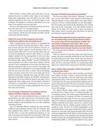 )
April 2024 - Maritime Reporter and Engineering News page: 27
)
April 2024 - Maritime Reporter and Engineering News page: 27with the USNS Howard O. Lorenzen (T-AGM 25) monitors mis- need mariners, too, and so does the rest of the maritime indus- sile launches and collects data. We have six ocean surveillance try. We’re certainly in a situation where we want to maintain ships. Five of them are catamarans that conduct long-range