Satellite Omponent
-
 )
March 2024 - Marine Technology Reporter page: 23
)
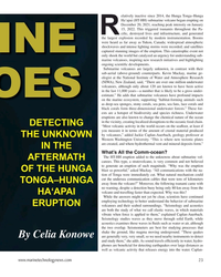
March 2024 - Marine Technology Reporter page: 23modern instrumentation. Booms were heard as far away as Yukon, Canada; widespread atmospheric shockwaves and intense lighting storms were recorded; and satellites captured stunning images of the eruption. This catastrophic event not only shook the world but catalyzed an urgency for understanding sub- marine
-
 )
March 2024 - Marine Technology Reporter page: 22
)
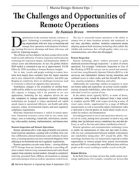
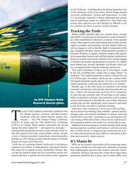
March 2024 - Marine Technology Reporter page: 22FEATURE OCEANOGRAPHIC INSTRUMENTATION & SENSORS Aerial view of HT-HH volcano, showing new multibeam depth data overlaid on islands satellite image. © SEA-KIT, NIWA-Nippon Foundation TESMaP 22 March/April 2024 MTR #3 (18-33).indd 22 4/4/2024 9:08:10 AM
-
 )
January 2024 - Marine Technology Reporter page: 20
)
January 2024 - Marine Technology Reporter page: 20. So we can link up to various wire- push for residency for ] autonomous subsea vehicles, [a subsea less communications including the growing low orbit satellite docking station that needs power]. There’s emerging things like network, Starlink and others. Within that we can offer a cost subsea data centers
-
 )
November 2023 - Maritime Reporter and Engineering News page: 73
)
November 2023 - Maritime Reporter and Engineering News page: 73liberation is well within reach with see what the market bares now that might meet our collective the only limiting factor being availability and full satellite needs. constellation deployment, which will occur sometime this The RDC has been evaluating and testing Starlink and re- year, depending on the
-
 )
November 2023 - Maritime Reporter and Engineering News page: 30
)
November 2023 - Maritime Reporter and Engineering News page: 30. This data comes from modelled data from global to several factors including material fatigue and the forces im- weather and marine models as well as satellite, lightning, weather posed on the hull as a result of the weather conditions. station, wave buoy, current meter, and tide gauge data. Some data Survey
-
 )
November 2023 - Maritime Reporter and Engineering News page: 22
)
November 2023 - Maritime Reporter and Engineering News page: 22Conference at this year’s London In- T ternational Shipping Week examined how the industry can move from talk to practical solutions that can ensure satellite technology plays a decisive role in shaping smarter and more sus- tainable shipping. Inmarsat Maritime presi- dent Ben Palmer provided the scene-settin
-
 )
November 2023 - Maritime Reporter and Engineering News page: 16
)
November 2023 - Maritime Reporter and Engineering News page: 16robots speci? cally designed to the operator and the robot, optimizing how limited radio or target microfouling (the early slime and algae that forms satellite bandwidth is used. A vessel’s crew merely needs on ship hulls), hull cleaning can be completed more eco- to communicate back to Greensea IQ that
-
 )
September 2023 - Marine Technology Reporter page: 51
)
September 2023 - Marine Technology Reporter page: 51back in real time over the available redundant communi- cations methods including RF for line of sight, cellular for nearshore when available, and satellite for over the ho- rizon operations. The USV can also be equipped with custom communications www.marinetechnologynews.com 51 MTR #7 (50-65).indd
-
 )
September 2023 - Marine Technology Reporter page: 23
)
September 2023 - Marine Technology Reporter page: 23to provide a ground truth for the satel- lite. The four Wirewalker moorings are part of an overall 11 mooring array, situated directly under the satellite ? ight path to gather snapshots of steric height for comparison with the measurements gathered from space. The Cal/Val moor- ings are designed
-
 )
September 2023 - Maritime Reporter and Engineering News page: 21
)
September 2023 - Maritime Reporter and Engineering News page: 21a user onsite to capture monitoring. For remote operations, the technical experts onshore, more simul- and stream video, with two-way audio load on satellite communications is far taneous work can be undertaken more communication, with experts viewing higher due to the requirement for ex- ef? ciently
-
 )
September 2023 - Maritime Reporter and Engineering News page: 20
)
September 2023 - Maritime Reporter and Engineering News page: 20to effectively digitalize their operations. Additionally, the technology enables an inspector to carry Nonetheless, changes in the availability of satellite band- out remote audits and inspections on several vessels simulta- width and the ability to use technology to better utilize avail- neously, alongside
-
 )
June 2023 - Marine News page: 19
)
June 2023 - Marine News page: 19mutu- ally recognizing and agreeing on new laws and regulations. As a maritime society, we have pro- gressed from sails to engines, from sex- tants to satellites, and from parallel rul- ers to GPS networks setting courses. As technology has advanced, the maritime industry has collaborated and met the challenges
-
 )
August 2023 - Marine News page: 45
)
August 2023 - Marine News page: 45? cient already commenced at the beginning OneWeb’s LEO Network mixed-? ow pump design, compact of 2023. MAN is currently planning a Flat panel satellite antenna company in-board footprint, narrow width for ? rst retro? t project based on an MAN Kymeta and low Earth orbit (LEO) compact driveline
-
 )
August 2023 - Marine News page: 20
)
August 2023 - Marine News page: 20solar powered “drifter” hull to track a voy- age across the Atlantic Ocean. Students in the program de- signed and built the boat, and then tracked it by satellite. The project allowed them to learn about ocean currents, weather, hull integrity and GPS technology. The ? rst drifter launched off the U.S. East
-
 )
May 2023 - Marine Technology Reporter page: 42
)
May 2023 - Marine Technology Reporter page: 42landing stations connected workforce and more ? exibility and reliability com- (CLS) – one located at Praia Grande, state of São Paulo and the pared to satellite connections that can be severely impacted by other at Praia da Macumba, state of Rio de Janeiro. weather and other natural events. Petrobras is
-
 )
May 2023 - Marine Technology Reporter page: 29
)
May 2023 - Marine Technology Reporter page: 29data standards, lite telemetry to increase understanding of The organization is also home to the stated communications manager Anja species movement. Satellite tags provide OTN Data Center (OTNDC), which con- Samardzic. “OTN partners with several a wide range and more data, while acous- nects a global
-
 )
May 2023 - Marine Technology Reporter page: 27
)
May 2023 - Marine Technology Reporter page: 27? cult to rely on, scientists now have an answer: marine telemetry. Tracking the Truth Marine wildlife telemetry takes two common forms: acoustic and satellite. Acoustic tags are predicated on a system of transmit- ters, either implanted in or attached to an animal. As the organism comes within range of
-
 )
May 2023 - Marine Technology Reporter page: 25
)
May 2023 - Marine Technology Reporter page: 25little as 1 cm in 4,000 m depth) caused by an earthquake in the deep ocean. If a tsunami wave is detected, an alert message is transmitted up to a satellite buoy on the surface. From there, it is relayed to the national Tsu- nami Warning Center onshore for com- parison with recent seismic activity. If
-
 )
May 2023 - Marine Technology Reporter page: 4
)
May 2023 - Marine Technology Reporter page: 4R. Trauthwein another piece of maritime business, a ‘bucket list’ trip to watch a SpaceX rocket launch [email protected] deliver a new Inmarsat satellite to orbit. Since I was in the neighborhood, I requested a Contributing Writers visit to FAU Harbor Branch Oceanographic Institute, and was welcomed
-
 )
April 2023 - Maritime Reporter and Engineering News page: 40
)
April 2023 - Maritime Reporter and Engineering News page: 40side passages for personnel on the navigation system includes a 2D surveillance radar, a naviga- main deck and around the same bridge. tion radar and satellite communications. LNG BunNer ShiS LaunFhed in China Alice Cosulich, the ? rst of two Small Scale & Bunker Vessels for Fratelli Cosulich Group was
-
 )
April 2023 - Maritime Reporter and Engineering News page: 39
)
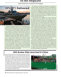
April 2023 - Maritime Reporter and Engineering News page: 39been advantage of real-time ocean surface measured using buoys, which are dif- currents offers new possibilities for ef- ? cult to place, or altimetry satellites, ? cient navigation. a limited resource since there are only eOdyn is a maritime software com- seven in orbit. OS technology generates pany based
-
 )
April 2023 - Maritime Reporter and Engineering News page: 36
)
April 2023 - Maritime Reporter and Engineering News page: 36we can get our hands on … our own net- to deliver the most ef? cient and least weather-restricted speed work of thousands of sensors worldwide, satellite data, data and waypoint recommendations to a ? eet. Powered by Sofar from public networks … and we put all of that information Ocean’s global
-
 )
April 2023 - Maritime Reporter and Engineering News page: 24
)
April 2023 - Maritime Reporter and Engineering News page: 24American Clean Power … amples include the bureaus’ coordination with NOAA and American Petroleum Institute … the Offshore Operators NASA on the use of satellites for OCS emissions and dis- Committee here in the U.S., and other organizations that are charge detection to help identify chronic violators and
-
 )
April 2023 - Maritime Reporter and Engineering News page: 13
)
April 2023 - Maritime Reporter and Engineering News page: 13as they spend underway. Students are required to look at all inputs and ensure they are properly set for the current conditions. They examine the satellite geometry of the GPS in order to determine its level of accuracy. They will determine what information is displayed as well as the alarm settings