Deep Sea
-
- Mapping the Abyss with AUV Photography Marine Technology, Mar 2015 #32
Despite being one of the largest habitats on Earth occupying around 60% of the surface, the deep-sea environment remains largely enigmatic. It was only in the late 1960’s that the abyssal plains were recognized to contain rich, complex habitats and play an important role in global carbon cycling. The technological and operational challenges that come with studying deep-sea environments have previously restricted research into the inhabiting species and ecosystem structure. The development of a novel photographic method for deep-diving Autonomous Underwater Vehicles (AUV), hails major advancements in deep-sea research, enabling scientists to map entire communities of benthic megafauna on remarkable scales.
The evolution of underwater vehicles and imaging technology has amplified efforts in seafloor mapping over the last decade. Only in recent years has more significance been placed on the location of species and the factors that influence ecosystem dynamics and biodiversity.
The intensification of industrial movements within the deep-sea setting creates the potential for loss in species abundance and many ecosystem services. Additionally, climate change can cause unexpectedly large changes to the deep-sea environment. As such, research into how these factors will impact deep-sea ecosystems has become a priority for many scientists. This can only be achieved however by understanding how these habitats work at present, which is critical for the ability to manage and conserve deep-sea environments in the future.
“If we wish to understand how the oceans work and what impact climate change may have on the function of the oceans, it is vital we understand the abundance, distribution and biodiversity of animals in the deep-sea,” said Dr. Kirsty Morris, Seabed Image Analyst at the UK’s National Oceanography Center (NOC) and the lead author of this research, published in ‘Limnology and Oceanography: Methods.’ “Only by knowing this, will we be able to begin to understand what impact climate change may have on the oceans productivity and carbon sequestration ability as a whole. It will also allow us to assess the impact of human activities such as deep-sea mining, oil and gas exploration, and the increasing presence of litter.”
Deepsea Survey Methods
Conventional methods for the study of deep-sea megafauna include trawl sampling and photographic and video surveys. Deep-sea trawling has often been used to assess diversity and density of species, but this method poses some technical issues and can only be used over a relatively small area. Scientific trawling can also be time consuming and does not provide spatial information on how the individuals were distributed. Furthermore, some species can be destroyed altogether in the process and often considerably under represented.
Towed cameras have much the same issues. While off-bottom towed cameras are able to provide within-transect spatial data, the tethered systems can be effected by swell causing difficulties in controlling the position, altitude, and speed of the camera. On-bottom towed camera sleds do have better stability but can damage the seabed and consequently the induced turbidity can cause issues with the image quality.
Remote Operated Vehicles (ROVs) are seeing an increasing use in deep-sea underwater exploration, and can now reach depths of up to 6,000 meters. ROVs are valuable in deep-sea studies as they are able to retrieve samples and provide researchers with high resolution imagery. The limitations however are that they once again cannot be used for large survey areas and require a lot of dedicated ship time, limiting the other science that can occur in conjunction.
AUVs can act as stable imaging platforms and cover large survey areas with little environmental impact in the form of noise pollution and disturbance. Additionally, AUVs do not require continuous lighting and can also collect large volumes of data efficiently without consuming ship resources. The species that are regularly under represented by other sampling methods can be observed and identified. At the same time, local environmental data such as habitat and resource availability can be recorded along with spatial and quantitative data. As such, it is recognized that AUVs have the potential to unlock previously inaccessible areas and rapidly increase our knowledge of species distribution across survey areas reaching up to landscape scales.
New Method for Deepsea Mapping
A new photographic processing technique developed by scientists at the National Oceanography Centre (UK), used a camera on the Autosub6000 AUV to enable them to take a continuous stream of high resolution photographs of life on the sea floor. This method was developed and tested as part of the NERC funded AESA (Autonomous Ecological Surveying of the Abyss) project and revealed a tenfold increase in the precision of deep-sea ecosystem diversity estimates, relative to the use of scientific trawling.
“We have developed a method where we are able to take a continuous image of the seafloor over scales not previously achieved. This was done by using an AUV to take images every 0.87 seconds with an overlap between each of the images,” said Dr. Morris. “This data can then be used to create maps of the seabed, detailing how many animals are present, where they are present in relation to one another and in relation to any features on the sea-bed, such as hills.”
Dr. Kirsty Morris was part of the team of scientists who developed an automated program where each of the images were corrected for non-uniform illumination (where one side of the image is darker than the other). A color correction also had to be applied where the red, blue and green light was ‘lost’ through the water column from the AUV to the seafloor. Each image was then geo-referenced using the heading, pitch and roll, recorded from the vehicle and re-scaled so that each pixel within each image represented the same area.
Using the positions of the images, it was then possible to work out the overlap and place them together in 10 image segments called tiles. Once these tiles were annotated for the presence and size of animals, the positions, length and identification of individual animals were recorded, creating a map of biodiversity on the seafloor.
“This technology is important because it allows us to create an image of the deep-sea over large areas, almost like a google street view. This is done in a cost effective manner using the AUV, meaning that the ship can be collecting other samples at the same time,” Dr. Morris said. “From these images, we get an insight into the deep-sea environment on scales not previously possible, which will enhance our understanding of that environment and our impact on it.”
The Future of AUV Photography
As climate change and growing human activity intensifies the pressure on seafloor resources, it is increasingly important to better document deep sea marine biodiversity and ecosystems. Technological advances such as deep-sea ROV and AUV systems have allowed us to begin accessing areas which were previously not possible. As these systems advance, there is an increased ability to cover even larger areas and develop more advanced mapping tools.
“It is hoped that there will be an increase in automation both in the image processing and in the image annotation. Automated annotation is something that would allow us to process the images and obtain results quicker; this is currently being worked on by some colleagues in Germany,” said Dr. Morris.
While this technique was developed to map the distribution and biodiversity of remote deep-sea communities, there are many applications which would benefit from AUV photography, with the potential to increase along with improved automation.
“I am currently working on a system to automatically detect and measure phytodetritus (organic particulate matter resulting from phytoplankton and other organic material in surface waters falling to the seabed) aggregation on the seabed using these images,” said Dr. Morris, “This will allow us to discern any link between the distribution of these aggregates with the topography of the seafloor and the animals that are in that area.”
The distribution, abundance and biodiversity of communities within any habitat is particularly important when establishing marine conservation areas. The method developed by NOC is currently being used to assess changes within community structure over a three year period within a marine conservation zone, Haig-Fras, in the Celtic sea.
A project called Shelfseas Biogeochemistry (SSB), will also utilize this technique to map out four different transect areas with various seafloor substrate (mud versus sand), assessing species composition in each area and if this changes following the plankton bloom in the spring.
In the future, advancements in automated technology and image processing will allow larger areas of the deep-sea to be mapped, increasing our understanding of the distribution of species, their abundance and biodiversity. This will allow researchers to better predict the impacts of climate change and ocean acidification and the consequent implications this would have for carbon sequestration, impacting the ocean ecosystem as a whole. Accurate environmental assessments of the impacts of human activities, such as deep-sea mining and oil exploration, will also become increasingly vital over the coming years. Not only can this technology accurately assess impacts in the direct vicinity of the activity, it will also be able to assess impacts over areas far larger, which is not economically viable with conventional deep-sea survey methods.
(As published in the March 2015 edition of Marine Technology Reporter - http://www.marinetechnologynews.com/Magazine)
-
- The Price of Subsea Mining Marine Technology, Oct 2017 #34
Over millions of years, metal particles accrete onto sediment grains slowly forming lumps of commercially-valuable metallic ores in deep aphotic basins three miles underwater. As resources dwindle, mining companies are increasingly looking to the ocean to provide the metals and minerals we need. But environme
-
- Island Performer for Deep-Sea Subsea Work Marine Technology, Sep 2014 #16
8- x 8-meter main moon pool. She is equipped with a 250-metric-ton AHC (active heave compensated) offshore crane with a below-deck winch, and carries two deep-sea work ROVs, one to be launched through a dedicated moon pool and the other from the starboard side,” Ulstein said. Island Performer is the next
-
- Sea Data Corporation Introduces Deep Sea Instrumentation Cable Maritime Reporter, Jan 15, 1985 #46
—Literature Available A new instrumentation cable, specifically designed to meet the needs of submersible instrumentation systems has been introduced by Sea Data Corporation of Newton, Mass. The company announced the availability of the cable with strain and waterproof molded connectors to meet
-
- Deep-Sea Towage, Salvage And Heavy-Lift Markets Maritime Reporter, May 1992 #54
and increasing economic discrimination each player is having to find new methods to secure a market position. Towage, for example, has lost part of its deep-sea market to heavy-lift vessels in some operational areas only to make gains elsewhere. New methods of handling heavy-lifts are proving more profitable
-
- Innovation @ URI: The smallest deep-sea system that can provide a livestream video feed Marine Technology, Apr 2021 #21
easy. Thanks to a new fiber optic reel system invented by Brennan Phillips, an assistant professor of ocean engineering at the University of Rhode Island, deep-sea exploration is about to get much more affordable and accessible.Shrinking the SystemHaving worked on large research vessels all over the world,
-
- MTR100: Deep-sea Mining May Prove Pivotal in the Climate Change Discussion Marine Technology, Sep 2022 #26
Minister for Marine Resources Heremoana Maamaatuaiahutapu in a television interview.French Polynesia is not alone with numerous groups worldwide, like the Deep Sea Conservation Coalition (DSCC), also fighting for a moratorium. However, this is only one side of the battle. On the other are nations like Nauru,
-
- Extreme Sampling: Hadal Trenches Marine Technology, Sep 2015 #34
unknown and challenging habitats on earth. These systems can be used for further studies of microbial ecology and biogeochemical processes at numerous deep sea locations.“ By comparing trenches from contrasting oceanic settings the project provides a unique analysis of Hadal biogeochemistry and a deeper
-
- Creating Superior Buoyancy with Air Marine Technology, May 2017 #18
make them stronger without burdening them with weight. The ability to manipulate that nothingness brings new opportunities to many fields, especially in deep sea exploration. Through the use of high–tech hollow glass microspheres (HGMS), the issue of weight for deep sea exploration vehicles can be overcome
-
- Subsea Mining: The Next Big Thing for UUVs Marine Technology, Mar 2019 #37
and commercialization. INESC TEC’s researchers have developed a disproportionate number of robots for ocean industries. These include the DART deep sea survey AUV and the autonomous deep-sea robotic lander dubbed, TURTLE.“The (TURTLE) has clear applications in subsea mining as it is a special
-
- Shell Ocean Discovery XPrize Field Pared to 9 Marine Technology, Apr 2018 #6
excited at what is coming out of this so far, and I think you will see some technologies emerge that truly revolutionize the way in which we access the deep sea and map the deep sea.” While Dr. Virmani is remiss for obvious reasons to tout one tech over the other, she said that teams are trying different
-
- MTR100: Global Maritime Mooring Group Marine Technology, Aug 2016 #22
Deep Sea Mooring, Moorland & Vryhof With the complexity and remoteness of offshore developments and the need to manage costs yet adhere to safety and asset integrity, Global Maritime is meeting customer challenges through a total mooring solution. Global Maritime Vryhof is a developer and provider of
-
 )
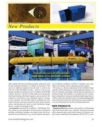
March 2024 - Marine Technology Reporter page: 48
)
March 2024 - Marine Technology Reporter page: 48Subsea . . . . . . . . . . . . . . . . . . . .www.blueprintsubsea.com . . . . . . . . . . . . . . . . . . . . . .+44 (0) 1539 531536 5 . . . . . .Deep Ocean Engineering, Inc. . . . . . . . . . . . .www.deepocean.com . . . . . . . . . . . . . . . . . . . . . . . . . . . . . .(408) 436-1102 33 . . .
-
 )
March 2024 - Marine Technology Reporter page: 43
)
March 2024 - Marine Technology Reporter page: 43which is a new generation of GeoAcoustics sub-bottom with Cathx Ocean that it says ‘radically’ reduces the time and pro? ling technology, reaching into deeper waters for the ac- effort required to detect and classify objects of interest in sea- quisition of essential data for e.g., the development and opera-
-
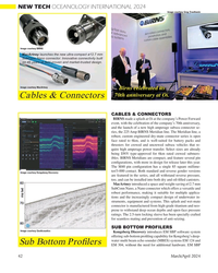 )
March 2024 - Marine Technology Reporter page: 42
)
March 2024 - Marine Technology Reporter page: 42of underwater in- struments, equipment and systems. This splash and wet-mate connector is manufactured from high-grade titanium and neo- prene to withstand deep ocean depths and open-face pressure ratings. The 2.5-turn locking sleeve has been specially crafted for seamless mating and prevention of anti-seizing
-
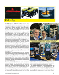 )
March 2024 - Marine Technology Reporter page: 41
)
March 2024 - Marine Technology Reporter page: 41Image courtesy Outland Technology Image courtesy Exail Image courtesy Submaris and EvoLogics Vehicles The ROV-1500 from Outland Technology represents a leap forward in underwater robotics, a compact remotely operated vehicle (ROV) weighing in at less than 40 lbs (19kg) the ROV- 1500 is easy to transport
-
 )
March 2024 - Marine Technology Reporter page: 40
)
March 2024 - Marine Technology Reporter page: 40Its gondola, located below the surface, can further host a wide 30 days) and can deploy multiple payloads and subsea assets. range of payloads such as deep-water Multibeam Echosound- The new DriX O-16 bene? ts from a hybrid propulsion, redun- ers (MBES), Sub-Bottom Pro? lers (SBP), or acoustic subsea
-
 )
March 2024 - Marine Technology Reporter page: 38
)
March 2024 - Marine Technology Reporter page: 38, largely due to their lower internal resistance. NiMH can is an affordable $189, while the Pro version is just $40 more. suffer longevity issues with deep discharge, but this may not be The CBA measures the actual amount of energy stored in a an issue if only a limited number of deployments are expected
-
 )
March 2024 - Marine Technology Reporter page: 37
)
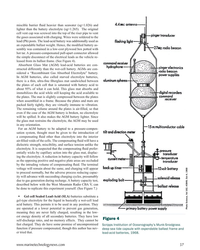
March 2024 - Marine Technology Reporter page: 37do have some promise of uncompromised Scripps Institution of Oceanography’s Munk-Snodgrass function if pressure compensated, though this author has nev- deep sea tide capsule with expendable ballast frame and er tried that. lead-acid batteries, 1968. www.marinetechnologynews.com 37 MTR #3 (34-47).indd 37
-
 )
March 2024 - Marine Technology Reporter page: 36
)
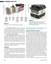
March 2024 - Marine Technology Reporter page: 36than 1C. (See Lander Lab #5, MTR, November/December 2022) Lead-acid wet-cells must remain upright or the electrolyte, a On March 26, 2012, James Cameron’s DEEPSEA CHAL- 35% sulphuric acid and 65% water solution, will spill. They LENGER submersible and ocean lander DOV MIKE demon- can be exposed to high ambient
-
 )
March 2024 - Marine Technology Reporter page: 35
)
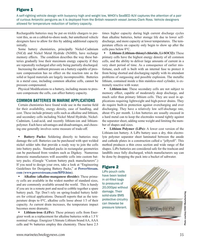
March 2024 - Marine Technology Reporter page: 35? Lithium-ion: These secondary cells are not subject to sure compensate the cells, can affect battery capacity. memory effect, capable of moderately deep discharge, and much safer than primary lithium cells. They are used in ap- plications requiring lightweight and high-power drains. They COMMON BATTERIES
-
 )
March 2024 - Marine Technology Reporter page: 34
)
March 2024 - Marine Technology Reporter page: 34electrolyte. The rates are largely driven by temperature. The colder tempera- galvanic difference between the cell anode and cathode is the tures of the deep sea will lower the capacity of most battery potential and measured in volts. A battery is made from some chemistries, some more than others. number
-
 )
March 2024 - Marine Technology Reporter page: 33
)
March 2024 - Marine Technology Reporter page: 33regulated industry in the world.” How- ever, commercial success depends on many factors, not least a predictable OPEX. Over the past four years, SMD has worked with Oil States Industries to calculate cost per tonne ? gures for prospective customers. Patania II uses jet water pumps to Oil States’
-
 )
March 2024 - Marine Technology Reporter page: 32
)
March 2024 - Marine Technology Reporter page: 32FEATURE SEABED MINING by a sea? oor plume from its pilot collection system test. pact, nodule collection system that utilizes mechanical and The Metals Company recently signed a binding MoU with hydraulic technology. Paci? c Metals Corporation of Japan for a feasibility study on The company’s SMD
-
 )
March 2024 - Marine Technology Reporter page: 31
)
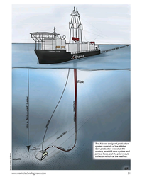
March 2024 - Marine Technology Reporter page: 31The Allseas-designed production system consists of the Hidden Gem production vessel at the surface, an airlift riser system and jumper hose, and the pilot nodule collector vehicle at the sea? oor. Image courtesy of Allseas www.marinetechnologynews.com 31 MTR #3 (18-33).indd 31 4/4/2024 2:12:41
-
 )
March 2024 - Marine Technology Reporter page: 29
)
March 2024 - Marine Technology Reporter page: 29n January, Norway said “yes” to sea- bed mining, adding its weight to the momentum that is likely to override the calls for a moratorium by over 20 countries and companies such as I Google, BMW, Volvo and Samsung. Those against mining aim to protect the unique and largely unknown ecology of the sea?
-
 )
March 2024 - Marine Technology Reporter page: 28
)
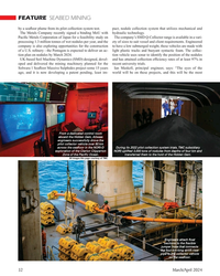
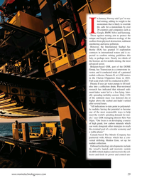
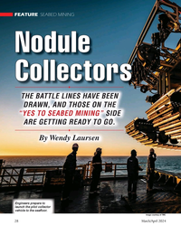
March 2024 - Marine Technology Reporter page: 28FEATURE SEABED MINING Nodule Collectors THE BATTLE LINES HAVE BEEN DRAWN, AND THOSE ON THE “YES TO SEABED MINING” SIDE ARE GETTING READY TO GO. By Wendy Laursen Engineers prepare to launch the pilot collector vehicle to the sea? oor. Image courtesy of TMC 28 March/April 2024 MTR #3 (18-33).
-
 )
March 2024 - Marine Technology Reporter page: 27
)
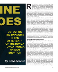
March 2024 - Marine Technology Reporter page: 27is rare. “The HT-HH eruption was a tragedy, but it was very unusual. It let us know that the hazard exists, but most submarine volcanoes are simply too deep to affect us in any way.” The uncommon eruption catalyzed global scienti? c collaboration and em- phasized preexisting research on subma- rine volcanoes
-
 )
March 2024 - Marine Technology Reporter page: 26
)
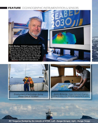
March 2024 - Marine Technology Reporter page: 26FEATURE OCEANOGRAPHIC INSTRUMENTATION & SENSORS Kevin Mackay, TESMaP voyage leader and Center head of the South and West Paci? c Regional Centre of Seabed 2030. Kevin in the seismic lab at Greta Point looking at the Hunga Tonga-Hunga Ha’apai volcano 3D map completed with data from the TESMaP voyage
-
 )
March 2024 - Marine Technology Reporter page: 25
)
March 2024 - Marine Technology Reporter page: 25, video images of the eruption’s impact. volcano in Hawai`i) and West Mata vol- with a dense ash layer found in the up- Equipment on board included a deep- cano in the Tonga arc. “We’ve seen a ton per water column near the site.” towed imaging system, multicorer, CTD of landslides in acoustic data recorded
-
 )
March 2024 - Marine Technology Reporter page: 23
)
March 2024 - Marine Technology Reporter page: 23be a gross under- estimate.” He adds that submarine volcanoes have profound impacts on the marine ecosystem, supporting “habitat-forming animals such as deep-sea sponges, stony corals, sea pens, sea fans, lace corals and black corals form three-dimensional underwater forests.” These for- ests are a hotspot
-
 )
March 2024 - Marine Technology Reporter page: 22
)
March 2024 - Marine Technology Reporter page: 22FEATURE OCEANOGRAPHIC INSTRUMENTATION & SENSORS Aerial view of HT-HH volcano, showing new multibeam depth data overlaid on islands satellite image. © SEA-KIT, NIWA-Nippon Foundation TESMaP 22 March/April 2024 MTR #3 (18-33).indd 22 4/4/2024 9:08:10 AM
-
 )
March 2024 - Marine Technology Reporter page: 11
)
March 2024 - Marine Technology Reporter page: 11assist in identifying mines and act as a neutralization device. About the Author Bottom mines pose even greater chal- David R. Strachan is a defense analyst and founder of lenges. Unlike contact mines, bottom Strikepod Systems, a research and strategic advisory mines utilize a range of sensors to
-
 )
March 2024 - Marine Technology Reporter page: 8
)
March 2024 - Marine Technology Reporter page: 8INSIGHTS SUBSEA DEFENSE Copyright RomanenkoAlexey/AdobeStock WHEN THE SHOOTING STOPS: BLACK SEA MINE CLEARANCE WILL FEATURE ADVANCED TECH, CONOPS By David Strachan, Senior Analyst, Strikepod Systems ince the beginning of the war in Ukraine, mine warfare mines have been the weapon of choice for both
-
 )
March 2024 - Marine Technology Reporter page: 2
)
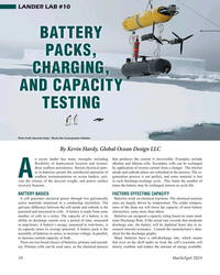
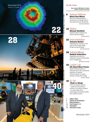
March 2024 - Marine Technology Reporter page: 2March/April 2024 On the Cover Volume 67 • Number 3 Image courtesy NIWA-Nippon Foundation TESMaP / Rebekah Parsons-King 8 Subsea Defense Black Sea Mines When the shooting stops in the Ukraine, the tough work of clearing mines will commence. By David Strachan 12 Gliders Slocum Sentinel 22 Teledyne
-
 )
March 2024 - Marine Technology Reporter page: Cover
)
March 2024 - Marine Technology Reporter page: CoverMARINE TECHNOLOGY REPORTER March/April 2024March/April2024 www.marinetechnologynews.com Oceanographic Instrumentation Exploring Submarine Volcanoes When the Shooting Stops Black Sea Mine Clearance Subsea Mining The Nodule Collectors Lander Lab Volume 67 Number 3 Battery Packs MarineTechn