Andy Sherrell
-
- D-Day Mapping Mission Marine Technology, Mar 2014 #56
It’s been almost 70 years since the invasion of Normandy, France when 156,000 Allied troops landed and began their march across Europe to defeat Hitler. And, while these soldiers’ collective destinies could not have been known at the time, their will to fight was unmistakable. General Dwight D. Eisenhower called the D-Day operation a crusade in which “we will accept nothing less than full victory.” The allied troops heard this charge and proved their resolve. The D-Day cost was high — more than 9,000 Allied soldiers were killed or wounded — but on Tuesday, June 6, 1944 more than 100,000 soldiers gained a crucial foothold in Normandy. (Source: D-Day - June 6, 1944 - the United States Army).
On D-Day and the days following, a 50-mile stretch of French coastline was overtaken by man and machine. In total there were 170,000 vehicles and 5,000-plus ships, including 702 war ships. The beaches of Normandy no doubt have a story to tell.
To honor those who served, a massive survey and archeological effort is underway sponsored by France Televisions, 13 other broadcasters and the Normandy region. The French Navy (Marine National) and Department of Underwater and Undersea Archeological Research (DRASSM) were involved as well. Involvement from Sherrell Ocean Services, Trimble Navigation, Ltd. and Measutronics Corporation, a Trimble authorized marine dealer, was also instrumental in making this expedition possible. Each company involved is committed to the effort and is graciously donating their time, equipment and expertise to the project. Covering approximately 500 square kilometers, this will be the largest continuous survey of this type ever completed in the region. Together, these groups are building a complete GIS database of the area based around the five invasion beaches of D-Day. The volunteers are sharing their professional expertise to preserve the Normandy beaches’ history as well as capture 3D images of the historic assets.
Through their survey and mapping work, the team is working to have the Normandy D-Day invasion coastline designated as a UNESCO World Heritage Site by the World Heritage Committee. A UNESCO World Heritage Site is a location that is identified as having special cultural or physical significance, not to a single nation, but to the world.
Beaches of Normandy - Survey
The Discovery Phase of the mapping expedition started in July 2013 with a catamaran and crew leaving from Port of Saint-Malo, France. The total survey effort took nearly seven weeks and involved bathymetric mapping with an EdgeTech interferometric multibeam / side scan sonar combined with the Trimble SPS855/555H GNSS modular heading bundle and an inertial motion reference unit (MRU). The Trimble SPS heading bundle outputs the position, heading and timing synchronization data to the multibeam data collection and processing software. Here it is stored and time-tagged to the sonar data. Geo-referenced point cloud and side scan data are displayed real time for review by the system operator as well as logged for further data editing, processing and mapping.
The Trimble SPS series heading bundle antenna array was mounted on center with the transducer mount pole near the bow of the catamaran vessel. A custom mount was developed and built to allow the entire survey sensor package to be retracted when entering or departing local ports, which have limited hull clearances, dependent upon tides. The interferometric sonar system afforded wide swath “point cloud” coverage for three-dimensional modeling and also provided side scan planimetric imagery to aid in target identification.
Measutronics Corporation, Trimble’s leading U.S. Marine dealer, was chosen for this project because of its experience in the field of marine guidance, mapping, imaging and equipment holdings. Lou Nash, Measutronic’s founder, explains that the GNSS heading bundle is critical to the bathymetric systems because, “without accurate positioning, you essentially don’t have a reference point or know where you are in relation to anything else; as a result you can’t accurately and efficiently trace back to targets in the water. In addition, the ‘motion of the ocean’ must be accounted for as all the sounding and image data collected are done so from a constantly moving platform – subject to the effects of vessel heave, pitch and roll.”
The Trimble SPS855 site positioning heading bundle was selected because of its accuracy and it’s interoperability with Fugro Marinestar satellite-based correction signals as well as shore-based reference stations. The SPS series heading bundle is also interoperable with a number of motion reference units (MRU). With inputs from the heading bundle receivers, the MRU provided a blended GNSS / inertial solution, compensating for the effects of heave, pitch and roll. The Marinestar correction service was chosen over land-based correction transmission stations as typical UHF radio transmission would have required increased logistics and would not have provided adequate coverage for a large portion of the offshore due to the extreme distances involved.
“We chose the Trimble receiver because it’s really the only modular receiver that delivers the flexibility, accuracy and performance that we needed on a marine mapping expedition as significant as this,” said Nash. “It tracks the full GNSS constellation, giving better positioning availability and high precision, plus our crew knows the equipment inside and out.”
Target Identification Phase
In mid-August the crew began to focus on further development of targets of interest identified during the previous weeks of surveying. Now mobilizing from Cherbourg, France, efforts included the use of SeaBotix remotely operated vehicles (ROVs) fitted with Tritech acoustic tracking devices and sonar. These efforts were used to prioritize those targets to be further developed / examined with a higher resolution multibeam sonar system. For the remainder of the survey, crews use the SeaBotix ROVs and a video camera along while continuing to collect multibeam data.
High-Interest Targets
For high resolution point cloud data collection, an R2Sonic 2024 Ultra High Resolution (UHR) mulitibeam sonar was used. With the ultra-high resolution sonar system, the crew collected high-resolution point cloud data for about 20 historic assets of particular interest.
As a further effort in providing the most accurate point cloud data possible, GNSS phase data and inertial data were collected and logged with an Applanix POS MV motion reference unit. Data were then post processed with Applanix’s POSPac MMS software providing a “true heave” blended GNSS / inertial solution. The post processed data files were then read into a hydrographic survey software package. Martin de Kievit, business development manager for Trimble Marine in the Heavy Civil Construction division, explains that the survey software grabs input from the GNSS receiver where it allows for display and editing of track lines, sounding profiles and text data. The software system correlates time-tagged tide, vessel position, motion and sound velocity correction data which are used to accurately plot and record locations.
“Our surveys reported some 300 targets [artifacts] and about 20 ‘new’ wreckage sites were more fully developed,” said Nash.
As submerged targets of interest were more fully developed and accurately located, crews also launched small manned submarines to capture film footage of various high-profile wreckage sites. Led by Andy Sherrell of Sherrell Ocean Services, the crew filmed sites in order to capture color and details of what the servicemen may have faced on that fateful June day. Using video, sonar, 3D imagery and 3D visualizations, the crew is essentially “peeling back the water to bring these stories to life,” Nash added.
With higher resolution images and precise point cloud data, the crew is hoping to determine the actual ship, aircraft or vehicle name of the artifacts revealed. With this information, historians will also endeavor to derive names, ranks and associations of the crewmembers that were aboard the vessels or vehicles when they were sunk and destroyed.
Updating the GIS Database
During the months to come, teams will continue to work with the massive 11TB data set. The United Kingdom Hydrographic Office (UKHO) and the French nautical charting authority (SHOM) are collaborating in an effort to update the international wreck database for the area. Because a large percentage of these identified artifacts are newly discovered or were inaccurately positioned previously, the team is working to make these corrections before they deliver the complete survey data to the UNESCO World Heritage Committee for review. To commemorate the event, MC4 and LCL Production are producing a 90-minute documentary for the international market. PBS/Nova will broadcast an adaptation in North America, both to be aired memorializing the 70th anniversary.
Honoring Those Who Were There on “The Longest Day”
During the official 70th Anniversary D-Day ceremony scheduled for June 2014, veterans, dignitaries and archeologists will meet along this historic coast to honor those who have served and sacrificed. Led by the French Department of Underwater Archeological Research, manned submarines will also escort a handful of WWII veterans and historians underwater to investigate a few of the high-profile identified wrecks.
“Nearly everyone we approached about providing support for this historic mapping expedition, by means of donating equipment or personnel, was extremely supportive and enthusiastic about the project,” said Nash. “Everyone has considered it an honor to be involved in this effort, and I know I feel that way, as do our guys.”
(As published in the March 2014 edition of Marine Technology Reporter - www.seadiscovery.com)
-
 )
April 2022 - Maritime Reporter and Engineering News page: 56
)
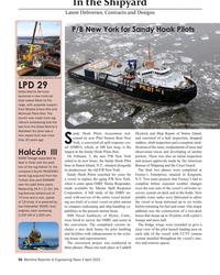
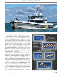
April 2022 - Maritime Reporter and Engineering News page: 56In the Shipyard Latest Deliveries, Contracts and Designs P/B New York for Sandy Hook Pilots Photo courtesy HII/Ingalls Shipbuilding Division LPD 29 Dales Marine Services launched a new multi-cat style vessel Réalt na Far- raige, with quayside support from Whytes Crane Hire and McIntosh Plant Hire.
-
 )
January 2022 - Marine Technology Reporter page: 38
)
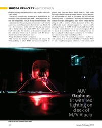
January 2022 - Marine Technology Reporter page: 38SUBSEA VEHICLES WHOI ORPHEUS Orpheus had only done three dives. It was Eurydice’s ? rst salt- gineers Andy Klesh and Russel Smith from JPL. TRN works water outing. by using software to pick up unique features in what the cam- The surveys covered coral mounds on the Blake Plateau, in- era sees and then
-
 )
January 2022 - Marine Technology Reporter page: 22
)
January 2022 - Marine Technology Reporter page: 22ICE PREDICTIONS’ ACCURACY, ACCESS By Rod Boyce Residents of Utqiagvik return by snowmachine from the lead at the edge of the shore-fast ice. Photo by Andy Mahoney, UAF Geophysical Institute 22 January/February 2022 MTR #1 (18-33).indd 22 1/25/2022 9:54:16 A
-
 )
November 2021 - Marine News page: 62
)
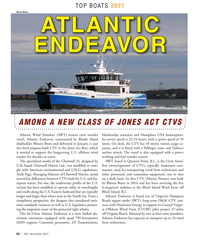
November 2021 - Marine News page: 62of CTVs, typically aluminum cata- ply with American environmental and USCG regulations. marans, used for transporting wind farm technicians and Andy Page, Managing Director of Chartwell Marine, noted other personnel, and sometimes equipment, out to sites several key differences between CTVs built
-
 )
July 2021 - Marine Technology Reporter page: 30
)
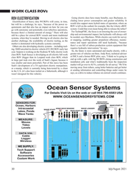
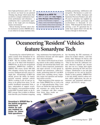
July 2021 - Marine Technology Reporter page: 30, the future is more automated and maybe electric, with a year. Saipem is working on the Hydrone W fully electric work greater mix of vehicles out there. Andy Rose, technical advisor class ROV. Saab Seaeye is developing an all-electric full work class ROV (bigger than its Leopard work class ROV, which at
-
 )
March 2021 - Marine Technology Reporter page: 52
)
March 2021 - Marine Technology Reporter page: 52Onboard360,” able quick installation onboard a range and sensor data for custom forwarding of vessel types, and it is compatible and processing. said Andy Hoggarth, VP Sales and Mar- keting. “Our Ping-to-Chart solution with QuietSea, Sercel’s Passive Acous- Its web-based user interface allows us- is now
-
 )
April 2021 - Marine News page: 41
)
April 2021 - Marine News page: 41Austal USA fective March 1. Lloyd’s Register named Mark Dar- Promotes Ryder ley as business director, marine and Shipbuilder Austal USA named offshore; Andy McKeran as business long-time business development ex- Sea Machines Hires director, maritime performance ser- ecutive Larry Ryder as the company’s
-
 )
October 2020 - Marine Technology Reporter page: 56
)
October 2020 - Marine Technology Reporter page: 56In? nity Fleet sociates; Hampton Mayor Donnie clear indication of the potential com- Ocean In? nity selected the Saab Tuck; Governor Ralph Northam; Andy mercial viability of early stage technol- Seaeye Leopard to complement its Green, president of HII’s Technical ogy in the subsea industry that enables
-
 )
September 2020 - Marine News page: 35
)
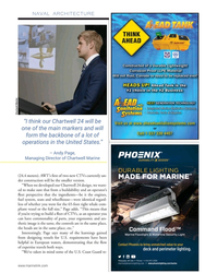
September 2020 - Marine News page: 35NAVAL ARCHITECTURE Chartwell Marine “I think our Chartwell 24 will be one of the main markers and will form the backbone of a lot of operations in the United States.” – Andy Page, Managing Director of Chartwell Marine (24.4 meters). AWT’s
-
 )
September 2020 - Marine News page: 33
)
September 2020 - Marine News page: 33.-based Dominion Energy. The connection between Chartwell Marnie and AWT extends beyond the most recent vessel order. Chartwell Marine’s managing director, Andy Page, was previously head designer at South Boats, the company that delivered the design for AWT’s (and the United States’)
-
 )
July 2020 - Marine Technology Reporter page: 19
)
July 2020 - Marine Technology Reporter page: 19satellite trackers that Ocean ship’s crew to home in on the debris. Voyages Institute designed with engi- They then recover the litter, place it in neer Andy Sybrandy of Paci? c Gyre, industrial bags, and store it in the ship’s Inc. The beacons are placed on nets by cargo hold for proper recycling and
-
 )
June 2020 - Marine Technology Reporter page: 26
)
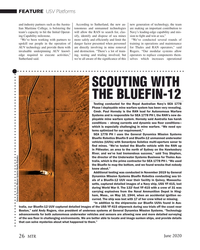
June 2020 - Marine Technology Reporter page: 26Bluefn UUVs found in Aus- tralia, our Bluefn-12 UUV captured detailed images of the USS YF-415 shipwreck during sea trials off the coast near Boston,” said Andy Rogers, vice president of undersea systems at General Dynamics Mission Systems. “Technology advancements for both autonomous underwater vehicles and
-
 )
June 2020 - Marine Technology Reporter page: 24
)
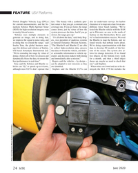
June 2020 - Marine Technology Reporter page: 24elements to slower, the range goes up.” Sydney on the Hawkesbury River, and generate an image, and in doing that, “It’s all about the data,” said Andy Rog- we’ve had tremendous success. We used we improve the signal to noise ratio, and ers, vice president of undersea systems the Bluefn to map the
-
 )
January 2020 - Marine Technology Reporter page: 54
)
January 2020 - Marine Technology Reporter page: 541, 2020, to December 31, 2022. Mitcham Names New Tech Positions Mitcham Industries, Inc. has made two additions to its technology development team. Andy Meecham has joined Mit- cham in the newly-created position of Vice President and Chief Technology Of? cer. Additionally, Dr. Peter Ram- say has joined
-
 )
January 2020 - Marine Technology Reporter page: 23
)
January 2020 - Marine Technology Reporter page: 23them useful for toring for Protected Areas and Species). buffeted by the wind and waves. When attaching to gliders, some of which al- Under COMPASS, Dr. Andy Dale and it dives, there’s a more complex pro? le ready have hydrophones.” For the mo- Dr. Denise Risch have been looking at than we would get from
-
 )
December 2019 - Maritime Reporter and Engineering News page: 12
)
December 2019 - Maritime Reporter and Engineering News page: 12and answer some of these ques- that the group members had to make Lrum for industry, academia and and investors because we act in a negli- tions. RDML Andy Sugimoto, who cur- sense of and respond to. regulators to gather, exchange notes and gent manner? What does it mean to be rently serves as the Coast
-
 )
November 2019 - Marine Technology Reporter page: 20
)
November 2019 - Marine Technology Reporter page: 202020 & Beyond: Subsea Mining Subsea Mining Will 2020 be the Year? Photo Courtesy Nautilus Minerals By Andy Lipman & Alan Yu, ABS nyone who has been around true mission – recovering a Soviet sub- In the years since, there has been a the Offshore Oil and Gas marine - was that the rig would be used great
-
 )
November 2019 - Marine Technology Reporter page: 4
)
November 2019 - Marine Technology Reporter page: 4. With that in mind we present Tel: (561) 732-4368; Fax: (561) 732-6984 several articles in this edition which help that process. Start- ing on page 20, Andy Lipman and Alan Yu from ABS ask if PUBLISHER 2020 will be the year for subsea mining. Subsea mining has captured the fascination of the John C.
-
 )
November 2019 - Marine Technology Reporter page: 2
)
November 2019 - Marine Technology Reporter page: 2. By Greg Trauthwein 6 Subsea Mining 20 Is 2020 the Year? When will industrial mining in the subsea environment ? nally make it to the mainstream? By Andy Lipman & Alan Yu, ABS Tech Trends 26 The March to Miniaturization A growing battalion of small, compact systems is taking the subsea world by storm
-
 )
October 2019 - Maritime Reporter and Engineering News page: 19
)
October 2019 - Maritime Reporter and Engineering News page: 19Maritime Administration, and Besides the symposium itself, the of academics, industry leaders and pub- poster. The only programmatic require- Rear Adm. Andy Tiongson, commander event will be host, for the second year lic servants. The diverse group produced ment is that the proposal address the of Coast
-
 )
July 2019 - Maritime Reporter and Engineering News page: 20
)
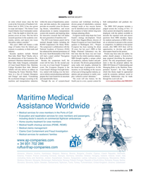
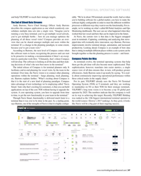
July 2019 - Maritime Reporter and Engineering News page: 20? ow, but also standardizes the way terminals work to improve the quality of the planning and tracking process to improve the termi- nal’s ef? ciency. Andy Barrons, CSO Navis The latest rollout of Compass will take place the Yilport Gebze and Yilport Gemlik, both in Turkey, Yilport Oslo, Yilport Setubal
-
 )
May/Jun 2019 - Maritime Logistics Professional page: 48
)
May/Jun 2019 - Maritime Logistics Professional page: 48Rosenberg, Jeff .................... 19, 20, 21 Axis Communications ......................... 31 Lundquist, Edward ................... 8, 24, 28 Barrons, Andy .................................... 37 MacDonnell Group ............................. 29 S, T Bay State Wind .................................. 33
-
 )
May/Jun 2019 - Maritime Logistics Professional page: 37
)
May/Jun 2019 - Maritime Logistics Professional page: 37software for a global market, you have to make the software highly con?gurable in order to meet the different work?ow The End of Siloed Data Streams Andy Barrons, Navis Chief Strategy Of?cer Andy Barrons processes or different ways they want to use the functionality. For ex- describes the compass application
-
 )
June 2019 - Marine Technology Reporter page: 59
)
June 2019 - Marine Technology Reporter page: 59. The business is a joint ven- Watch it on MTR TV! vibrating ring design which means they ture, owned by Collins Aerospace and MTR TV spoke with Andy Hughes, can deliver a unique combination of pre- Sumitomo Precision Products and, after Sales Manager, Silicon Sensing re- cision performance and