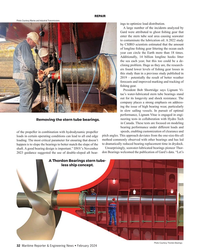
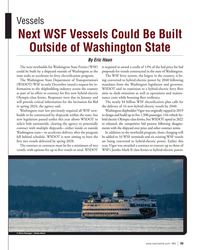
Mark A Jadkowski
-
- Smooth Sailing Maritime Reporter, Mar 2000 #34
Electronic update service for digital charts equals a radical new service in the United States The entire suite of 1,000 official NOAA nautical charts has been available in digital raster form since 1995.
These high quality, full color, geo-referenced images of NOAA's paper charts are made for use in computer-based navigation systems and work with GPS or other electronic positioning systems.
They are produced jointly by NOAA and Maptech, Inc. under a cooperative research and development agreement (CRADA).
Mariners quickly adopted raster nautical charts. Their rapid adoption was aided by first-rate navigation software available from many companies at an affordable price. Today, the raster charts outsell NOAA's paper charts by eight to five. Each CD-ROM, containing about 55 charts, has grown to include the Coast Pilot, marine facilities, indexing and viewing software, and other facilities - all at no additional cost.
The final capability needed for raster charts is a practical means of applying the Notice to Mariners corrections that are issued weekly. With a reliable, officially approved update service, raster charts will be suitable for professional use and will meet the international standards for Electronic Chart Display and Information Systems (ECDIS).
Updating the Charts NOAA compiles nautical charts with computer-assisted cartographic tools.
The resulting digital files are used to make both paper and raster charts. Historically, new information was saved until about 50 critical changes had accrued and then the files would be updated and a new edition issued.
To support a weekly update service, NOAA remade its production system, processes, and procedures. More than 40,000 outstanding corrections were applied to eliminate the existing backlog of changes. This was no easy feat and took more than one year to accomplish.
Today, all 1,000 charts are continually updated for changes from the Coast Guard, NIMA, and the Canadian Hydro- graphic Service Notices to Mariners in the same week the Notices are issued.
These files are then available for printing new charts and for Maptech to make raster chart updates.
The Digital Patch Technology The corrected raster files are too large to be distributed as updates (about 100 megabytes per chart). Instead, NOAA and Maptech developed a special "patch" technology. In this method, a pixel-by-pixel comparison is made between the old raster chart file and the updated one. A difference file is made that contains exactly those pixels, which, if overlaid on the old raster chart, turn it into the new one.
Maptech makes this difference file, adds the geo-referencing, metadata, and information that allows an update patch to be exactly registered with the old raster file to which it will be applied.
The difference file is then compressed using a special algorithm developed by NOAA and Maptech to create a small (1 to 100 KB with 99 percent smaller than 10 KB) patch for each raster chart.
To update a raster chart, the old raster file is displayed from the CD-ROM and immediately "wiped-over" with the patch file. Where no pixels were different between the old raster chart and the new, the patch acts like it has transpar- ent pixels and unchanged pixels from the old chart show through.
This novel differencing technique can be used to create sequential, week-toweek patches, or to create cumulative patches that include all changes since a new chart edition. It can also be used to overlay other geo-referenced raster data on top of the chart.
The technology, production and distribution methods were jointly developed over the last two years. Maptech invested more than six staff years in technology development (exclusive of manufacturing, sales and distribution) and NOAA also invested heavily to produce a reliable updating infrastructure. Sea trials in 1999 have proven the method and added to its robustness.
The Raster Chart Updating Service The updating service became available in January 2000 as a subscription, consisting of a weekly e-mail containing a hot link to the update computer server.
When a mariner clicks on the hot link, it begins the transmission of the update patches to his computer. The transmission contains cumulative updates for all the charts on a CD-ROM. It takes 15 seconds to more than five minutes to download the file — depending on one's modem speed. When file reception is complete, a program on the mariner's computer unpacks the updates for immediate use, or copies charts from the CD-ROM, applies the patches, and then stores the updated charts on the hard drive.
At first, mariners will update the charts and store them on their hard drive. Then, as software developers modify their navigation packages, dynamic updating should be available.
With dynamic updating, the charts and patches remain separate and the patch is "wiped over" the chart in real-time. This allows mariners to see that the patch is applied and to see what has changed, an important capability for mariners who transit a waterway frequently. Dynamic patching is also the preferred method under the international standards for ECDIS where mariners are required not to alter the original data files. Either patching method will let the mariner toggle between the old chart and the new chart, or to view the patch by itself.
Maptech provides the update service as part of its CRADA partnership responsibilities. It comes packaged in a new, professional-level product. On each CD-ROM, mariners receive about 55 raster charts, the Coast Pilot, Light List, Tide Tables, Tidal Current Tables — where they exist — and update services for one year as a package deal.
Notice that the CD-ROM contains all of the items called for in the Coast Guard's charts and publications carriage regulations.
Official Status With the availability of the weekly update service, NOAA is permitting its logo to be used on the commercial raster chart product. Accompanying text explains that the raster charts (and updates) were produced under the authority of NOAA, the national hydrographic office for the United States. This status makes them suitable for meeting the international standards for ECDIS In addition, NOAA and the Coast Guard have been working closely during the development of the ECDIS standards.
That three-step, standards-setting process (International Hydrographic Organization standards for data, International Maritime Organization standards for systems, and International Electrotechnical Commission standards for type-approval) is nearing completion.
Then, it is expected that the Coast Guard will amend the chart carriage regulations to permit the use of electronic charts and publications.
This U.S. raster chart update service is the first electronically delivered weekly service. Priced substantially below the cost of the few similar services available elsewhere in the world, it is a significant step in providing mariners a professional, modern navigation service in U.S.
waters. Future plans may include the availability of single-chart updates rather than an entire CD's worth, and the inclusion of weekly updates to the Coast Pilot, Light List, and tide and current tables, as NOAA is able to provide the data. High accuracy vector data (called electronic navigational charts, ENCs) will also become available, with weekly updating, for the most demanding navigation in restricted and congested waterways.
It is expected that these ENCs and updates will be added to the professional navigation product.
The preceding was co-authored by David B. Enabnit, Office of Coast Survey, NOAA; and Mark A. Jadkowski, Maptech, Inc.
-
 )
March 2024 - Marine Technology Reporter page: 25
)
March 2024 - Marine Technology Reporter page: 25.” In all, Maxlimer Tonga’s severed domestic internet cable mapped more than 800 km2 and travelled was buried under 30 m of ash and sedi- TESMaP Makes it Mark 1331 nautical miles over 34 days. ment, added Skett. Impacts on the eco- In April 2022, four months after HT-HH system differed; the volcano was devoid
-
 )
March 2024 - Marine Technology Reporter page: 4
)
March 2024 - Marine Technology Reporter page: 4Editorial NIWA-Nippon Foundation TESMaP/ Rebekah Parsons-King www.marinetechnologynews.com ast month marked the resounding NEW YORK 118 E. 25th St., New York, NY 10010 return of Oceanology Interna- Tel: (212) 477-6700; Fax: (212) 254-6271 tional in London, perennially one Lof the world’s most important
-
 )
April 2024 - Maritime Reporter and Engineering News page: 40
)
April 2024 - Maritime Reporter and Engineering News page: 40All the objects detected by the computer vision system, in- there are large numbers of small vessels around. It is hard to cluding non-AIS vessels and sea marks, can be projected on predict what these vessels are going to do, and this racks up to electronic charts. Additionally, real-time risk analysis func- cogni
-
 )
April 2024 - Maritime Reporter and Engineering News page: 10
)
April 2024 - Maritime Reporter and Engineering News page: 10maritime safety and SIRE 2.0 brings digital reporting and real-time analytics, to environmental responsibility to unprecedented levels. the fore, marking a signi? cant technological stride. These in- SIRE 2.0 represents an update and a comprehensive reimag- novations offer a depth of insight into
-
 )
April 2024 - Maritime Reporter and Engineering News page: 6
)
April 2024 - Maritime Reporter and Engineering News page: 6challenges facing the [email protected] This incident again highlights how ‘out commercial industry at large: the need for Corporate Staff Manager, Marketing of sight, out of mind’ the maritime world modern tonnage and the need for trained Mark O’Malley momalley@marinelink is to the general public
-
 )
April 2024 - Marine News page: 21
)
April 2024 - Marine News page: 21, say, between BOEM and the line vessel routes. U.S. Coast Guard, this seems to remain a cooperative, • If deliberate separation isn’t feasible additional mark- friendly effort. Nevertheless, in recent agency ? lings in ing and lighting should include Automatic Identi? cation response to BOEM’s proposed
-
 )
April 2024 - Marine News page: 4
)
April 2024 - Marine News page: 4[email protected] sel emits no noise or vibration as it plies SALES the waters of San Diego Harbor 100% on Vice President, Sales & Marketing Terry Breese • [email protected] battery power—no diesel engines, no emissions. Tel: 561-732-1185
-
 )
February 2024 - Maritime Reporter and Engineering News page: 44
)
February 2024 - Maritime Reporter and Engineering News page: 44cargo ships, that operate in coastal ond and third vessels planned for 2026 areas with access to hydrogen infra- and 2027. structure. This development marks a signi? cant step towards sustainable and environmentally friendly maritime solu- tions. 3D Scanning yanmar.com GE Vernova 44 Maritime Reporter
-
 )
February 2024 - Maritime Reporter and Engineering News page: 32
)
February 2024 - Maritime Reporter and Engineering News page: 32levels of ? shing gear losses in this study than in a previous study published in 2019 – potentially the result of better weather forecasts and improved marking and tracking of ? shing gear. President Bob Shortridge says Lignum Vi- tae’s water-lubricated stern tube bearings stand out for its longevity and
-
 )
February 2024 - Maritime Reporter and Engineering News page: 6
)
February 2024 - Maritime Reporter and Engineering News page: 6for our technologies. [email protected] February 2024 cover story, as in ARC you One such mover is Seaspan Corporation Corporate Staff Manager, Marketing have neatly rolled up a company that em- and its program with the Maersk McKinney Mark O’Malley momalley@marinelink bodies so many key tenets
-
 )
February 2024 - Marine News page: 39
)
February 2024 - Marine News page: 39a minimum of two year, Vigor was awarded a contract to convert up to three of vessels, with options for up to ? ve vessels in total. WSDOT WSF’s Jumbo Mark II class ferries to hybrid-electric power. © Chris Fabregas / Adobe Stock www.marinelink.com MN 39
-
 )
February 2024 - Marine News page: 4
)
February 2024 - Marine News page: 4[email protected] ? rst wave of commercial-scale projects con- SALES tinue to build up. “Intelatus maintains its Vice President, Sales & Marketing Terry Breese • [email protected] forecast of more than 65 projects that will install around 90 GW of
-
 )
January 2024 - Marine Technology Reporter page: 35
)
January 2024 - Marine Technology Reporter page: 35humans need to take the pulse of the planet. America. “As I’m on deck here, I can’t help but think about the sto- The Foundation Expedition last September marked the start ries that inspire me, of sailors getting in one of these wooden of a new realm in McNeill’s journey to bridge discovery and vessels and
-
 )
January 2024 - Marine Technology Reporter page: 31
)
January 2024 - Marine Technology Reporter page: 31mid-life tom; the power and sensing modules; Franscisco was decommissioned in refueling. San Francisco was in com- and the business end, which is a Mark 2022 and is now MTS 711 at Charles- mission for more than 41 years, while 54 Lightweight homing torpedo. This is a 600-pound weapon with a range
-
 )
January 2024 - Marine Technology Reporter page: 4
)
January 2024 - Marine Technology Reporter page: 4me a clear and unfettered view (though not for attribution or reporting) Justin Zuure on the path, direction and importance of the CEO subsea vehicle market. Sitting at that table John C. O’Malley [email protected] that night were several U.S. Navy Admirals as well as the CEOs from about a dozen
-
 )
January 2024 - Maritime Reporter and Engineering News page: 39
)
January 2024 - Maritime Reporter and Engineering News page: 39catering equipment could extend the lifespan of a ship’s about this,” Tenovuo said, noting that some cruise operators galley by two years. now want to mark the walls of their store rooms with a line to ALMACO also works with its partners to ? nd ways to limit indicate maximum loading height. single-use
-
 )
January 2024 - Maritime Reporter and Engineering News page: 21
)
January 2024 - Maritime Reporter and Engineering News page: 21COATINGS Figure 6. The M/V Mark W. Barker sports exterior topcoats in The Interlake Steamship Company’s distinctive red (hull) and brown (freeboard). coat with a DFT of 20 to 25 mils. Aluminum oxide was added for at least a decade before dry docking – nearly double the for slip resistance and texture
-
 )
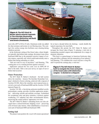
January 2024 - Maritime Reporter and Engineering News page: 19
)
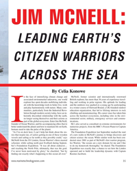
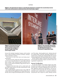
January 2024 - Maritime Reporter and Engineering News page: 19COATINGS Figure 1. The M/V Mark W. Barker is speci? cally designed to navigate the occasionally narrow rivers and con? ned ports scattered across the Great Lakes region. All images courtesy of The Interlake Steamship Company Figure 2. Distinguished by its Figure 3. The Interlake Steamship square-shaped
-
 )
January 2024 - Maritime Reporter and Engineering News page: 18
)
January 2024 - Maritime Reporter and Engineering News page: 18, Great Lakes Region & Matt Heffernan, Commercial Marine Business Manager, North America, Sherwin-Williams Protective & Marine he Motor Vessel Mark W. Barker – the ? rst U.S.- advanced coatings systems to ensure durability. Initially built constructed freighter of its kind in almost four to transport
-
 )
January 2024 - Maritime Reporter and Engineering News page: 14
)
January 2024 - Maritime Reporter and Engineering News page: 14The Path to Zero work to make OceanWings suitable for lyzed the vessel’s behavior in relation to its maiden voyage – marking it as the commercial vessels was actually a scale the use of its four OceanWings. ? rst modern wind assisted modern ship down of the original design. The wing- Their goals went
-
 )
January 2024 - Maritime Reporter and Engineering News page: 6
)
January 2024 - Maritime Reporter and Engineering News page: 6in eight full pages starting on page 22. Corporate Staff activities of companies leading the various The path toward decarbonization is a long Manager, Marketing Mark O’Malley sectors, if for no better reason than the vast one, fraught with many bumps, hurdles, momalley@marinelink majority shun media
-
 )
November 2023 - Marine Technology Reporter page: 28
)
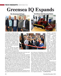
November 2023 - Marine Technology Reporter page: 28and ribbon-cutting Vehicles (AUGVs), event hosted by Greensea IQ in offering a range of Cordage Park showcased some re- sizes to meet diverse markable technology by Bayonet, mission require- a Greensea IQ company. Other ments. The Bayonet manufacturers, including SeaT- AUGVs are renowned rac
-
 )
November 2023 - Marine Technology Reporter page: 4
)
November 2023 - Marine Technology Reporter page: 4interest was my interview with Henry Ruhl and Corporate Staff Amy West of Synchro. Synchro is a program designed to help take subsea technology Manager, Marketing Mark O’Malley from the workbench to commercialization, a process that has always fraught with hurdles [email protected] and sinkholes.
-
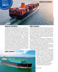 )
December 2023 - Maritime Reporter and Engineering News page: 38
)
December 2023 - Maritime Reporter and Engineering News page: 38meters and Seri Damai and Seri Daya have enhanced cargo tank insu- a capacity of 23,600 TEU, it is the largest cargo ship ever to lation with the GTT Mark-III Flex PLUS cargo containment sail under German ? ag. The container ships in the Hamburg system which is designed to reduce the boil-off rate