Esa
-
- Evolution of Ocean Exploration: Mapping the Seafloor with Geodesy Marine Technology, Mar 2016 #28
The evolution of ocean exploration continues with seafloor mapping with Geodesy.
In an age where the surface of Mercury and Mars can be mapped in great detail, it’s difficult to imagine how around 85-95 percent of our ocean floor remain enigmatic. While advanced sonar technology has allowed ships to create highly detailed topographic maps, it would take 125-200 ship-years to survey the deep oceans alone, costing billions of dollars. Gravity models are powerful tools for charting large areas of the ocean where tectonic structures and deep ocean basins remain unmapped by ships or hidden under thick sediment.Now, the new marine gravity model announced by a team of international scientists’ shows unprecedented resolution of the seafloor uncovering several new tectonic features. It is an exciting time for ocean exploration as each new year reveals more of the uncharted oceans, catalyzing new developments in plate tectonics, navigation, petroleum exploration and earthquake forecasting.While ship-based surveys remain a vital and valuable tool, topographic mapping is limited by the number of ship crossings. As such, only around 11 percent of the seafloor has been mapped at high resolution and 17 percent at lower resolution to date. In 1978, NASA’s Seasat altimeter was the first to demonstrate the ability to gather seafloor bathymetry from space.“When I was a graduate student I worked on Seasat, which was a NASA altimeter satellite,” said David Sandwell, Scripps Institution of Oceanography. “When the data came out from Seasat everyone realized that the data we were looking at looked like the ocean floor – we were looking at the ocean surface topography, but it looks like the seabed. That was probably then we realized we could use gravity field data to map the ocean floor.”The broad bumps and dips of the ocean surface mimics the topography of the seabed. The extra gravitational attraction of features on the seafloor produces minor variations in the pull of gravity that produce tiny variations in ocean surface height. These bumps and dips can be mapped using a very accurate radar altimeter mounted on a satellite.For decades, David Sandwell from the Scripps Institution of Oceanography and Walter Smith from the National Oceanic and Atmospheric Administration (NOAA) have been using Earth’s gravity field data from the civilian and military satellite operators. By combining new radar altimeter measurements from satellites such as the European Space Agency’s (ESA) CryoSat-2 and NASA CNES Jason-1 with existing data, a global marine gravity model was constructed that is two times more accurate than previous models. The team of scientists included R. Dietmar Müller from the University of Sydney, EmmanuelGarcia of NOAA and Richard Francis from ESA. The data they collected regarding gravity measurements and sea surface heights have formed unprecedented detailed maps of beneath the oceans’ surfaces.“We’ve been doing this for a longtime – at first we got data from a satellite called Geosat which was a U.S. Navy satellite launched in 1985. A breakthrough in altimeter coverage became available in 1995 when the United States Navy declassified the data from their mapping missions. The next big breakthrough was the CryoSat-2 ESA, which maps of the changing topography of the icecaps and over the ocean. It’s really a wonderful platform because it has better accuracy and coverage than all previous altimeters,” said Sandwell.Global maps constructed using satellite-derived gravity data will never replace the ships. The resolution of this new method is limited by the ocean depth because the potential field which gets smooth as you go from the bottom of the ocean to the surface. Whereas, the standard ship-based multibeam echo-sounders resolves features on the seafloor in high resolution about 100 meters across. The problem is in our lifetime we will probably never see the complete mapping of the seafloor by ships. Which makes the satellite data vital to filling in the gaps.The main challenges scientists face in developing these gravity field models is improving the resolution from the satellite altimetry data. Sea surface topography is a noisy measurement as the waves roughen the ocean’s surface making the range measurement less precise.The Age of Charted OceansThe two big areas of discoveries this model has already uncovered is found on the flanks of the seafloor spreading ridges; there’s a fabric called the Abyssal Hills. These hills are parallel to the spreading ridge and were yet to be resolved in the old gravity fields. “These hills are important because when the water moves across the bottom of the oceans due to the tides, it hits the hills generating ‘internal waves’. These internal waves propagate up and mix the ocean, keeping the ocean from always being warm on top and freezing on the bottom. So, understanding where theses hills are and how they interact with the tides is important and a big science project,” said Sandwell.The second big area is at the continental margins, which is where the plates split apart during rifting, forming fracture zones and transform faults. These are locations typically buried under sediments on the fl anks of the continental margins, making them difficult to detect using ships. This new data allows researchers to see the fracture zones under the sediment which can be used in detailed plate tectonics as well as identifying sedimentary basins when searching for oil.Ocean Exploration with Marine Gravity ModelsOne the real uses of the gravity field for seafloor mapping is identifying features that are unmapped, but also big in size such as large sea mounts and other structures. This allows researchers and commercial operators to target ship surveys to complete detailed mapping.“The original reason these altimeters were launched by the U.S. Navy was to map out the variations in the pull of gravity their effects on moving platforms. The military applications are obvious and provided the rationale for the $80 million cost of the Geosat mission,” said Sandwell. “When you’re in a submarine you can’t use your GPS because you’re under the water, so you use these precise accelerometers to measure your trajectory but you also have to know the gravity field, otherwise you might think you’re turning but you’re actually going straight. It’s called ‘inertial navigation’. Aircrafts also use this.” The global gravity grids also revealed half of all volcanoes on the seafloor reaching heights greater than 1000m, which were previously uncharted. The large petroleum exploration companies also use satellite altimeter gravity data from Geosat and ERS-1 to locate offshore sedimentary basins in remote areas. This information is combined with reconnaissance surveys to determine where to collect or purchase multi-channel seismic survey data.Evolving Marine Gravity ModelsThe project is still evolving and the interpretation of the results is yet to be completed. As these gravity fields are developed, the fine detailed of tectonic structures formed up to 150 million years ago will need to be interpreted. The objectives of this work will be to unravel the marine tectonics environments and other types of data that needs to be combined into current models.“In terms of improvements to the marine gravity models, CryoSat is still up there and will run till at least 2017 hopefully – and every year of data it gives us another improvement in the resolution of the gravity fields so that’s good. There’s another altimeter up there launched by the French and the Indians called SARAL which has improved technology with better resolution than CryoSat. It’s a slow process but over the years the gravity resolution will improve,” said Sandwell. “Also, there is not a good global compilation of ship mapping locations or data, because it is done by dozens of different countries and companies. The big improvement would be to assemble all the data that’s ever been collected and figure out where the holes are so we can go out systematically and map them.”In January 2016, Google replaced its global seafloor map with an improved version constructed using the latest gravity predictions and the available multibeam sounding data. NASA has a planned swath altimeter mission, SWOT, scheduled for a launch in 2020, that could provide another factor of 5 improvement in global ocean floor bathymetry.Satellite technology is always evolving, helping scientists follow the movements of Earth’s tectonic plates over time and target areas to study further using sonar scanning. While the increased use of non-invasive methods promise a more environmental friendly future, the continuous discoveries of new seafloor features in deep-sea marine territories marks a huge milestone in understanding our planet.AcknowledgementsProfessor David Sandwell, Scripps Institution of Oceanography
The AuthorKira Coley graduated with a BSc. (Hons) Marine Biology degree from University of Portsmouth and has extensive experience as a Field Scientist in various locations.(As published in the March 2016 edition of Marine Technology Reporter: http://www.marinetechnologynews.com/magazine) -
- Rolls-Royce Blue Ocean Team Looks to the Future Maritime Reporter, Feb 2017 #40
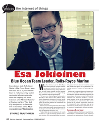
Esa Jokioinen leads Rolls-Royce Marine’s Blue Ocean Team, a team that looks five to 10 years into the future to evaluate evolving technology trends, helping to determine where the company will invest. Jokioinen sat in Maritime Reporter & Engineering News’ New York City headquarters to discuss the look of
-
- INMARSAT Set For February 1 Start Maritime Reporter, Oct 15, 1981 #6
needed to meet expected growth in calls, are: MARECS, maritime version of the European Communications Satellite, leased from the European Space Agency (ESA). The first MARECS will be placed in orbit over the Atlantic Ocean by the end of this year. Its launch vehicle is the European Ariane Rocket. INTELSAT
-
- Exploring Alien Oceans with AUVs Marine Technology, Oct 2016 #22
several spacecraft have already completed a mixture of long-term and flyby missions, 2030 will be the decade both NASA and the European Space Agency (ESA) launch further data-collection missions of Europa’s environment and begin the search for life. Mission Europa-Explorer The German Research Center
-
- The Ocean's Microplastics Mess: Technology & Technique to Identify & Clean Up Marine Technology, Jun 2020 #12
. It starts early on in our waterways and often near urban areas, contaminating and breaking down in rivers, lakes and harbors. Research conducted by Theresa Talley, a California Sea Grant extension specialist and researcher at Scripps Institution of Oceanography (UC San Diego), shows that in a sample of
-
- GALILEO: 2008 or Bust? Maritime Reporter, Jul 2002 #28
an information day for enterprises wishing to participate in the Galileo program. Representatives from the Commission, the Galileo Joint Undertaking, ESA and from a consultant will inform enterprises on the development of the program, the steps leading to the choice of the future concessionaire and
-
- Advancing Climate Change Research and Hydrocarbon Leak Detection Marine Technology, Mar 2013 #18
Ocean Observations and Information for Society” Conference (Annex), Venice, Italy, 21-25 September 2009, Hall, J., Harrison D.E. & Stammer, D., Eds., ESA Publication WPP-306. (2) Fiedler, B., Fietzek, P., Vieira, N., Silva, P., Bittig, H.C. and Körtzinger, A. (2013): In situ CO2 and O2 measurements
-
- Simulation: CSMART Maritime Reporter, Mar 2017 #60
System is based on the real ships application. The applied closed circuit TV (CCTV), recording and archiving system is similar to the CCTV used at the ESA Space Centre, with 90 full HD cameras observing and recording everything on the bridges and in the engine room to allow full picture team training.
-
- MG3 & Satellite Derived Bathymetry Marine Technology, Apr 2018 #20
of an online portal to support direct sales of the off-the-shelf Satellite Derived Bathymetry data along with other geospatial marine products. The ESA grant required TCarta and DHI to include existing clients in the development of the portal, and MG3 gladly served that role, offering its insights into
-
- Offshore Wind: a Freshening Breeze? Marine News, Sep 2019 #40
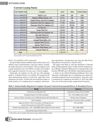
Federal Environmental Review & Permitting Process:StudyAgencyConstruction and Operations PlanDepartment of Interior (DOI) and BOEMEndangered Species Act (ESA) ConsultationDOI – Fish & Wildlife Service (FWS)Section 10 Rivers and Harbors Act of 1899 and Section 404 Clean Water ActUS Army Corps of EngineersESA
-
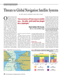
- Threats to Global Navigation Satellite Systems Maritime Reporter, May 2015 #26
provides only regional coverage, however China has announced plans to provide global coverage by the year 2020. In Europe, the European Space Agency (ESA) continues development of the Galileo satellite navigation system. When complete, Galileo will provide low precision PNT services to the general public
-
- Losing ontact... Not an Option Maritime Reporter, Mar 2004 #44
and services Kongsberg Seatex AS signed an agreement with the Galileo Joint Undertaking (GJU), which originates from the European Space Agency (ESA) and the European Union (EU). GJU is responsible for the development and implementation of Galileo — Europe's state-of-the-art global navigation system
-
 )
October 2023 - Marine News page: 18
)
October 2023 - Marine News page: 18situa- groups regarding protections for the Rice’s whale, a species tion is particularly perplexing. already protected under the Endangered Species Act (ESA) For some time now, we’ve eagerly awaited the launch of and the Marine Mammal Protection Act (MMPA). the upcoming federal offshore oil and gas leasing
-
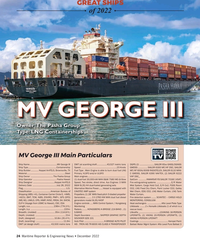 )
December 2022 - Maritime Reporter and Engineering News page: 24
)
December 2022 - Maritime Reporter and Engineering News page: 24– CARGO HOLD (ME/AE), UWILD, CPS, HIMP, HVSC, RRDA, SH, SHCM, generators model 6L35/44DF MONITORING, CONSILIUM- CLP-V (Voyage from USWC to Hawaii), CSC, ESA Engine controls .....MAN Control System / Kongsberg Heat exchangers ........................Alfa Laval Plate Type Length, o.a. ...............
-
 )
September 2022 - Marine Technology Reporter page: 76
)
September 2022 - Marine Technology Reporter page: 76side of a boat. Funded by the PML internal research program and the European TRITECH INTERNATIONAL Institute’s Sea Ice Prediction Network Space Agency (ESA), the study “De- Tritech’s portfolio consists of a suite of (SIPN) 14 years ago. As the amount of tection and Classi? cation of Floating Mechanically
-
 )
July 2022 - Marine Technology Reporter page: 59
)
July 2022 - Marine Technology Reporter page: 59on Earth using the map. A – manual or AI trained – image selection process starts and is linked to satellite data archives of the European Space Agency (ESA). Following that, the physics based SDB analysis creates the gridded bathymetry surface that align with ISO and OGC standards. As an option, QAQC
-
 )
September 2021 - Marine Technology Reporter page: 54
)
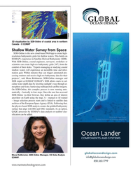
September 2021 - Marine Technology Reporter page: 54BioConsult SH developed by a team of scientists in Germany and the UK, detects whales from space. Supported by funding from the European Space Agency (ESA) Space Solutions program, this fundamental research enables whales and other large marine megafauna to be surveyed at an unprecedented scale. Earth
-
 )
July 2020 - Marine Technology Reporter page: 16
)
July 2020 - Marine Technology Reporter page: 16en- in conjunction with funding from the Eu- this point, spectral signature becomes ables distinguishing plastics from both ropean Space Agency (ESA), has been key for discrimination, and we use that natural materials and other plastics. working to detect aggregated patches of to check each highlighted
-
 )
Nov/Dec 2019 - Maritime Logistics Professional page: 22
)
Nov/Dec 2019 - Maritime Logistics Professional page: 22, the Federal Insecticide, Fungicide, change the existing penalty scheme for APPS violations. and Rodenticide Act (FIFRA), the Endangered Species Act (ESA) and the Comprehensive Environmental Response, Compensation, and Liability Act How to Respond to Enforcement (CERCLA). He counsels clients with respect
-
 )
September 2019 - Marine News page: 40
)
September 2019 - Marine News page: 40Vineyard Wind, events may still turn as the com- Endangered Species Act DOI – Fish & Wildlife pany needs, but will that be timely? A Record of Decision (ESA) Consultation Service (FWS) is not an ending; it allows the next step within a much big- Section 10 Rivers and Harbors US Army Corps of ger process
-
 )
Jul/Aug 2019 - Maritime Logistics Professional page: 40
)
Jul/Aug 2019 - Maritime Logistics Professional page: 40Environmental Review & Permitting Process: Study Agency Construction and Operations Plan Department of Interior (DOI) and BOEM Endangered Species Act (ESA) Consultation DOI – Fish & Wildlife Service (FWS) Section 10 Rivers and Harbors Act of 1899 and Section 404 Clean Water Act US Army Corps of Engineers ESA
-
 )
July 2019 - Marine News page: 52
)
July 2019 - Marine News page: 52River near An- chorage, AK, have a history of innovation from aluminum landing craft to Bristol Bay gillnetters. They recently sea trialed Bryan Mcmahan’s Esa Ruth, the ? rst of their latest pair of Bristol Bay boats that will be turning some heads on the Bay during this Summer’s sockeye season. The boats
-
 )
April 2018 - Marine Technology Reporter page: 22
)
April 2018 - Marine Technology Reporter page: 22capturing the survey data Bathymetry data along with other geospatial marine products. requested by the client, which may include putting a smaller The ESA grant required TCarta and DHI to include exist- boat in the water. But that option presents its own risks. ing clients in the development of the portal
-
 )
October 2017 - Maritime Reporter and Engineering News page: 16
)
October 2017 - Maritime Reporter and Engineering News page: 16The (Software) Link: Design & Operational Esa Henttinen is Executive Vice Presi- dent, NAPA, in the NAPA Group, a lead- ing software house. Henttinen holds a Master’s degree in Naval Architecture Safety in Cruise from the Helsinki University of Technol- ogy (Aalto University). It seems simplistic to
-
 )
October 2017 - Maritime Reporter and Engineering News page: 8
)
October 2017 - Maritime Reporter and Engineering News page: 8Allan Ltd. Rollie has more Peter Pospiech has served as chief Henttinen than 40 years of experience in Canada engineer in the German merchant Keefe Esa Henttinen is Executive Vice Presi- and the U.S. covering in ship opera- marine and additionally done ? eld Joseph Keefe is the lead commentator dent
-
 )
March 2017 - Maritime Reporter and Engineering News page: 61
)
March 2017 - Maritime Reporter and Engineering News page: 61system is similar to the CCTV used at the closely model today’s technologically advanced cruise using navigator and co-navigator roles. The navigator, ESA Space Centre, with 90 full HD cameras observing ships, providing an authentic shipboard experience for who is “conning” the ship, is required to verbally
-
 )
February 2017 - Maritime Reporter and Engineering News page: 40
)
February 2017 - Maritime Reporter and Engineering News page: 40oices the internet of things Photo: Rolls-Royce Esa Jokioinen Blue Ocean Team Leader, Rolls-Royce Marine hen Esa Jokioinen and his Rolls-Royce tivity, prices will come down but overall the cost per Esa Jokioinen leads Rolls-Royce Blue Ocean Team look at future technolo- ship should nudge above that
-
 )
October 2016 - Marine Technology Reporter page: 31
)
October 2016 - Marine Technology Reporter page: 311,100 bar exter- ning for a “real” mission to Europa and seek collaboration nal pressure, a feature also planned for a later date. with NASA or the ESA. “For us, it was more important to be able to ? rst show our “As well as space, some people are interested in using this ability to create a functioning
-
 )
October 2016 - Marine Technology Reporter page: 25
)
October 2016 - Marine Technology Reporter page: 25already completed a mixture of long-term and ? yby missions, 2030 will be the decade Reliable Under Pressure. both NASA and the European Space Agency (ESA) launch further data-col- lection missions of Europa’s environ- ment and begin the search for life. Mission Europa-Explorer The German Research Center
-
 )
July 2016 - Maritime Reporter and Engineering News page: 34
)
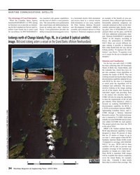
July 2016 - Maritime Reporter and Engineering News page: 34basis.” Once RCM is launched, SAR images will be available that almost completely cover the Grand Banks, for example, Credit: (Original satellite image: ESA; processed by C-CORE; INSET Photo: C-CORE) every day. Currently it takes nearly three days to achieve that coverage. The 34 Maritime Reporter
-
 )
March 2016 - Marine Technology Reporter page: 29
)
March 2016 - Marine Technology Reporter page: 29? oor uncovering several new manuel Garcia of NOAA and Richard Navy satellite launched in 1985. A tectonic features. It is an exciting time Francis from ESA. The data they col- breakthrough in altimeter coverage be- for ocean exploration as each new year lected regarding gravity measurements came available
-
 )
May 2015 - Marine Technology Reporter page: 34
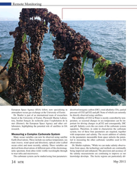
)
May 2015 - Marine Technology Reporter page: 34Remote Monitoring European Space Agency (ESA) fellow, now specializing in dissolved inorganic carbon (DIC), total alkalinity (TA), partial atmosphere-ocean gas exchange at the University of Exeter. pressure of CO2 (pCO2) and pH. None of which can currently Dr. Shutler is part of an international team of
-
 )
May 2015 - Marine Technology Reporter page: 33
)
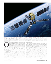
May 2015 - Marine Technology Reporter page: 33Source: ESA/AOES Medialab Artistic impression of the The Soil Moisture and Ocean Salinity (SMOS) satellite in orbit around the Earth. The SMOS satellite and its sensor have been monitoring the Earth’s soil and oceans since late 2009 and the salinity data are now beginning to be used for supporting ocean
-
 )
May 2015 - Marine Technology Reporter page: 2
)
May 2015 - Marine Technology Reporter page: 2member list to 90. By William Stoichevski 6 Editorial 8 People & Companies 14 Tech File 50 50 Products 63 Classifeds 64 Ad Index Bibby HydroMap Source: ESA/AOES Medialab May 2015 MTR 2 MTR #4 (1-17).indd 2 MTR #4 (1-17).indd 2 4/29/2015 9:31:10 AM4/29/2015 9:31:10 A
-
 )
May 2015 - Maritime Reporter and Engineering News page: 26
)
May 2015 - Maritime Reporter and Engineering News page: 26consideration in several countries. Large and small businesses now use au- ous, real time plot of the true and relative rope, the European Space Agency (ESA) Eventually, Loran C systems throughout tomated systems that can track, update, movements of both the vessel and near- continues development of the
-
 )
October 15, 1981 - Maritime Reporter and Engineering News page: 4
)
October 15, 1981 - Maritime Reporter and Engineering News page: 4, CARSON, CALIFORNIA 90749 TELEPHONE: (213) 518-1100 • TELEX: 181098 NATIONWIDE DISTRIBUTION Satellite, leased from the Euro- pean Space Agency (ESA). The first MARECS will be placed in orbit over the Atlantic Ocean by the end of this year. Its launch vehicle is the European Ariane Rocket