Gui
-
- MTR100: Editor’s Choice - Five Stand-Outs Marine Technology, Aug 2015 #50
MTR’s roving correspondent Kira Coley was tasked to identify and deliver five innovative companies worthy of inclusion in the 10th Annual MTR100.
Deep Trekker Inc
40 Melair Drive
Ayr, ON Canada
N0B 1E0
T: 519-342-3177
[email protected]
W: www.deeptrekker.comDeep Trekker Inc.
Deep Trekker Inc. was founded in 2010 with a mission to bring a fully capable yet portable and accessible remotely operated vehicle to market. Over the last 5 years, Deep Trekkers ROVs have quickly been adopted around the world as the go to underwater observation tool. Based on clean-sheet, innovative engineering, Deep Trekker offers a new breed of submersibles. Deep Trekker products are used across the world for applications including aquaculture, commercial diving, salvage, military, oil & gas, marine survey, research and recreation.
As the World’s first fully Portable Vectored ROV, Deep Trekker’s DTX2 patented pitching system is combined with powerful vectored thrusters for unprecedented flexibility and movement in the water. Forward, reverse, up, down, and lateral movements are available in 360 degree vertical and horizontal planes using only 4 thrusters. Vertical movements are accomplished using the main thrusters instead of relying on substandard vertical thrusters, providing unmatched speed & maneuverability. The DTX2 comes with many options for sophisticated add-ons such as single and multi-beam sonar, USBL positioning, Cutter Attachments, Cygnus Thickness Gauge, tether lengths up to 300 M. Intelligent features come as standard with the DTX2 ROV System, allowing users to work in higher currents and maintain stability.
Taking its cues from larger ROVs, the DTX2 brings all of the functionality required for difficult jobs, but without the usual complexity. Building on the proven DTG2 platform, Deep Trekker offers unparalleled ease of use and simplistic sophistication.
Schmidt Ocean Institute
555 Bryant Street, #374
Palo Alto, CA 94301
T: (650) 681-8460
E: [email protected]
W: www.schmidtocean.org
Founder/President: Eric SchmidtSchmidt Ocean Institute
Established in 2009, the Schmidt Ocean Institute strives to advance the frontiers of ocean research and exploration through novel technologies, intelligent observation and analysis. The last year has seen their involvement in many ground-breaking projects, pushing the boundaries of innovation and marine research. Schmidt Ocean Institute approaches oceanographic research from the technological, operational, and informational perspectives. The institute maintains and operates R/V Falkor as a technologically advanced scientific platform suitable to support multidisciplinary oceanographic research and technology development. Collaborators get free access to R/V Falkor with her on-board research facilities and expert technical support in exchange for a commitment to openly share and communicate the outcomes of their research.
In March 2015, the Schmidt Ocean Institute worked with the University of Sydney, MIT, as well as other institutions on the “Coordinated Robotics” project, which was also featured in June 2015 issue. The goal was to expand techniques for efficiently coordinating deployments of multiple exploratory underwater vehicles by advancing algorithms and their autonomous capabilities. The success of the project has brought engineers even closer to leaving groups of vehicles untended for long periods for a variety of underwater observation and data collection missions.
The “Perth Canyon: First Deep Exploration” was another project based in one of Australia’s proposed national reserves. Despite being just 50 kilometers or so from Western Australia’s capital of Perth, the canyon’s deeper reaches remained poorly known and largely unexplored until 2015, when scientists from the University of Western Australia onboard Schmidt Ocean Institute’s Research Vessel Falkor explored the region, along with a deep-diving remotely operated vehicle.
Xeos Technologies Inc.
Address: 36 Topple Drive,
Dartmouth, N.S.
B3B 1L6
T: 902-444-7650
E: [email protected]
W: www.xeostech.comXeos Technologies
With decades of manufacturing experience, Xeos Technologies have successfully designed market leading wireless telemetry products for use in the world’s harshest environments. Products range from deep sea alarm beacons to surface oil spill tracking systems to land based perimeter surveillance systems. Xeos is an Iridium Value Added Reseller and provides contract engineering services in addition to its standard product line. All these qualities have brought them success in their four divisions: Communications, Oceanographic Asset Recovery, Remote Monitoring and Security.
The Apollo is an independently powered, self-contained mooring beacon with the power of an ultra-bright LED Flasher combined with satellite communications. Users receive notification of the Apollo’s arrival at the surface from anywhere on earth via the Iridium Low Earth Orbit satellite communication system. This beacon provides unparalleled visibility, even in the worst conditions.
Apollo is fully submersible and has been rated to 11,000 m (36,089 ft) below sea level. In addition, the solid state surface sensor provides a measure of reliability unavailable in mechanical methods. The new APOLLO unit combines all the best features of Iridium communication beacons and LED Flashers, along with up to 10 years deployment on alkaline batteries.
With older style VHF beacons, a handheld “direction finder” would need to be used to locate equipment, sometimes in very harsh conditions. The APOLLO can receive a real-time GPS location from virtually anywhere and then relay the beacon’s current coordinates, allowing a quick recovery of equipment.
The Xeos APOLLO is a fundamental improvement over older technology and provides a single unit that will meet and exceed any requirements for depth, extended deployments, non-corrosive material construction, as well as the enhanced capabilities of a combination GPS/Iridium/LED flasher.
dotOcean Nautical
Innovations
Address: Pathoekeweg 9 B02
8000 Bruges
Belgium
T: +32 (0) 50 68 30 54
E: [email protected]
W: www.dotocean.eudotOcean Nautical Innovations
dotOcean develops pioneering measurement instruments for sediment profiling, sensor networks and data acquisition platforms for the maritime and offshore industry. Its unique product range is making its mark in the industry and they are quickly emerging as a market leader in sediment profiling technology. Today dotOcean offers a range of innovative measurement instruments and rapid development services. Their expanding range of products have applications in many areas including dredging, port and offshore construction and subsea pipeline installation.
The GraviProbe is a free fall impact instrument, analyzing the underwater sediment layers during intrusion. Under its own weight it accelerates and penetrates fluid and consolidated mud layers.
The rheological conditions of the soil layers are determining the probe’s dynamical behavior. The data acquired from on-board accelerometers, inclinometers and pressure sensors is feeding a model which determines the rheological parameters of the intruded medium (depth, undrained shear and viscosity).
As a result the GraviProbe is able to very accurately distinguish the depth of the fluid mud and consolidated mud layers, even in gaseous environments.
The high sensor data acquisition rates of up to 2kHz in combination with a low drag housing results in the highest quality profiles at drop rates over 7 m/s. Due to its light weight, the probe can be operated manually from a small vessel, platform or quay, limiting operational costs.
Additional products include the GraviProbe Rheology which provides tip resistance and shear strength and the GraviProbe Soil which has a conus extension to penetrate hard, stiff sediment layers.
Teledyne Bowtech Ltd.
ABZ Business Park
International Avenue
Dyce, Aberdeen
AB21 0BH, UK
T: +44 (0)1224 772345
W: www.bowtech.co.ukTeledyne Bowtech
Teledyne Bowtech specializes in the design, manufacture and supply of underwater vision systems, offering the industry an extensive range products including video inspection systems, underwater cameras and underwater LED lights. Teledyne Bowtechs’ products can be deployed at any ocean depth in harsh environments within the ROV AUV, Oil and Gas, defense, oceanographic, nuclear, leisure and marine science industries.
The Tech
The SURVEYOR-HD PRO ultra-wide angle underwater HDTV camera is designed to provide the viewer a greater angle of view, from the standard Surveyor HD, whilst remaining compact and very competitively priced. The camera is ideal for ROV inspection tasks, scientific observation and broadcast applications. Video output is available as HD or HD-SDI over fiber.
This camera sits at the top of their product range and has recently been used by Curtin University in partnership with the Western Australian Museum on an expedition to survey the wrecks of the HMAS Sydney and the HSK Kormoran.
The camera is available in a variety of control formats, including the Bowtech Products GUI, which facilitates the control of all features including white balance, auto tracking and back light compensation, which can be switched on or off using the GUI.
Excellent images are obtained, through the fused quartz hemisphere window and the camera is ideal for overall scenes and close-up inspection while using a remote control setup. The optics are also fully corrected for radial lens distortion and chromatic aberration. The camera is housed within a 4,000m rated titanium housing, as well as a 6,000m option with a fused quartz hemisphere window.
The MTR100 is Marine Technology Reporter's Annual report on 100 leading companies in the subsea industry, published in the July/August 2015 edition of MTR - http://www.marinetechnologynews.com/Magazine
-
- SWM Uses Automation To Speed Workflow Maritime Reporter, Oct 2000 #44
20-in. computer monitors mounted into a control console that is adjacent to the existing manual system. The control system's graphical user interface (GUI) was developed for Microsoft Windows 98/2000 technology. Having the two monitors side-by-side allows an operator to view different elements of the
-
- Advances in CAD and CAM System Integration Maritime Reporter, Sep 2002 #30
of today. This has included the change from 2-D to 3- D CAD, a dramatic increase in the level of usability (example: from batch mode to fancy 3-D GUI's) and increased functionality within the tools themselves. With the development of these tools has also come improved integration of the CAD and
-
- MTR100: Teledyne Marine Marine Technology, Jun 2019 #46
Teledyne’s emerging project UNITY, Teledyne Marine is taking the power of these sensors to the next level by creating a fully integrated, easy to operate, GUI to enhance and simplify ROV operations. With UNITY, operators can quickly and easily manage their vehicle’s tracking, positioning, and navigation systems
-
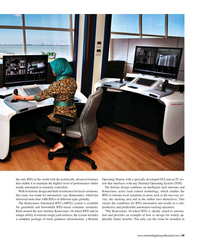
- Staying Vigilant On and Beneath the Waterline Marine News, Jun 2020 #32
harbors; a space that’s about as challenging as you can get for sonar, says Tomlinson.For the user, there’s a simple to interpret graphical user interface (GUI) with easy to use automatic obstacle detection and classification. The Vigilant displays have been designed to be clear and informative without the
-
- Tech File: HydroComp NavCad for Optimized Design Marine News, May 2017 #50
allow the ADVM method to be run as a coupled solver, including a batch or macro scripting API for data and processes, and quiet mode operation without the GUI (server mode). NavCad can be coupled with third-party software such as Excel or Matlab, as well as optimizing-purposed tools like CAESES. The NavCad
-
- FORAN V50 Coming Soon Maritime Reporter, Mar 2001 #23
focus. There are also interesting options for navigation through the model in real time. The new kernel also includes a new graphic user interface (GUI) that is native to Microsoft Windows; that is to say that it is based on the intrinsic resources of the operating system and needs no emulation
-
- Seamless Hydrographic Workflow: Processing Evolved Marine Technology, Jun 2017 #36
in the hydrographic workflow by researchers and engineers at Quality Positioning Systems (QPS) have automated the mundane, human-error prone tasks and guide users through the hydrographic workflow. This workflow removes redundancy, capitalizes on advanced computing technology to provide a dynamic multidimension
-
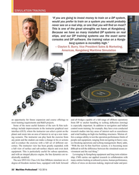
- Simulating the Next Big Thing Maritime Logistics Professional, Q1 2016 #30
and R&D projects. Some of the more useful features of the new K-Sim technology include improvements in the instructor graphical user interface (GUI), where the instructor can select a point on the planet and zoom into an area of interest to set up a new training scenario. The instructor can play
-
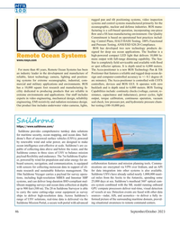 )
September 2023 - Marine Technology Reporter page: 46
)
September 2023 - Marine Technology Reporter page: 46, com- arc minutes). The Accu-positioner is controlled with COTS mercial and military applications and environments. ROS controllers, devices and ROS GUI. It operates with zero has a 10,000 square foot research and manufacturing fa- backlash and is depth rated to 6,000 meters. ROS Testing cility dedicated
-
 )
December 2022 - Maritime Reporter and Engineering News page: 40
)
December 2022 - Maritime Reporter and Engineering News page: 40and go back, which can also lead measurements via Miros’ cloud-based graphical user interface to turbine downtime. What we do is give real-time wave mea- (GUI) Miros.app. surement within the farm, and maybe mix it with the weather As part of three 3-year contracts and project requirements for forecasts.
-
 )
September 2022 - Marine Technology Reporter page: 61
)
September 2022 - Marine Technology Reporter page: 61optional) and rear (low light) cameras with 3 LED lights emitting 30,000 total Lu- mens with adjustable brightness controlled by the pilot con- trol box or GUI. www.marinetechnologynews.com MTR #7 (50-65).indd 61 10/3/2022 1:08:12 P
-
 )
September 2022 - Marine Technology Reporter page: 59
)
September 2022 - Marine Technology Reporter page: 59to start a reduced amount of time. Lighter COTS controllers, devices and ROS developing AI-based systems that tar- than traditional vessels, and partic- GUI. It operates with zero backlash and gets those specialist applications, such ularly hydrodynamic, DriX helps is depth rated to 6000 meters. as depth
-
 )
September 2022 - Marine Technology Reporter page: 57
)
September 2022 - Marine Technology Reporter page: 57, RADAR, AIS, IMU, depth transducer and video cameras and provides obstacle detection, dynam- ic path planning, and situational awareness via ENC-based GUI, tracker targets, video, and au- dio streams. AI-ris utilizes standard marine sensor and chart data fused with computer vision, auton- omous control
-
 )
September 2021 - Marine Technology Reporter page: 66
)
September 2021 - Marine Technology Reporter page: 66survey lines, result- total Lumens with adjustable brightness controlled by the pilot ing in an estimated 40% increase in ef? ciency. control box or GUI. https://mind-technology.com https://www.deepocean.com Copenhagen Subsea A/S Headquartered and inspired by its namesake city, Copenhagen Subsea melds
-
 )
September 2021 - Marine Technology Reporter page: 47
)
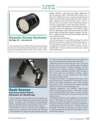
September 2021 - Marine Technology Reporter page: 47led by Bob Acks, for more than cu-positioner is controlled with COTS controllers, devices 40 years Remote Ocean Systems has been a leader in the and ROS GUI. It operates with zero backlash and is depth development and manufacture of latest technology camer- rated to 6000 meters. www.marinetechnologynews
-
 )
July 2020 - Marine Technology Reporter page: 50
)
July 2020 - Marine Technology Reporter page: 50op- tional) and rear (low light) cameras with 3 LED lights emitting 30,000 total Lumens with adjustable brightness controlled by the pilot control box or GUI. July/August 2020 50 MTR MTR #6 (50-63).indd 50 8/13/2020 9:58:40 A
-
 )
July 2020 - Marine Technology Reporter page: 49
)
July 2020 - Marine Technology Reporter page: 49Ocean Systems has been a cu-positioneris controlled with COTS controllers, devices leader in the development and manufacture of camera, light- and ROS GUI. It operates with zero backlash and is depth ing and positioning systems for the most extreme oceano- rated to 6000 meters. Its control system enables
-
 )
June 2020 - Marine News page: 44
)
June 2020 - Marine News page: 44. “For naval oper- For the user, there’s a simple to interpret graphical user in- ations, with Vigilant, operatives can be prepared for the unex- terface (GUI) with easy to use automatic obstacle detection pected, whether they’re in a swimmer delivery vehicle (SDV), and classi?cation. The Vigilant displays
-
 )
July 2019 - Marine Technology Reporter page: 47
)
July 2019 - Marine Technology Reporter page: 47companies have a level by creating a fully integrated, easy CTDs for conductivity, temperature and long history of supplying critical sen- to operate, GUI to enhance and simplify depth measurements sors and systems to out? t and empower ROV operations. With UNITY, opera- • Benthos acoustic modems
-
 )
Mar/Apr 2019 - Maritime Logistics Professional page: 39
)
Mar/Apr 2019 - Maritime Logistics Professional page: 39the only RTG in the world with the technically advanced features Operating Station with a specially developed GUI and an IT sys- that enable it to maintain the highest level of performance whilst tem that interfaces with any Terminal Operating System (TOS). totally automated or remotely controlled. The
-
 )
Q1 2016 - Maritime Logistics Professional page: 32
)
Q1 2016 - Maritime Logistics Professional page: 32and ballast nology include improvements in the instructor graphical user control room training, for example, they have even conducted interface (GUI), where the instructor can select a point on the research studies into key areas of interest such as seasickness planet and zoom into an area of interest
-
 )
September 15, 1977 - Maritime Reporter and Engineering News page: 7
)
September 15, 1977 - Maritime Reporter and Engineering News page: 7used herein, shall refer to any voyage between any port on the U.S. East Coast, or Gulf Coast, and any port on the Carib- bean Sea, West Indies, the Gui- anas and the Amazon River, in any order of rotation whatsoever, as approved by the U.S. Coast Guard. The change was made to ensure that
-
 )
November 1980 - Maritime Reporter and Engineering News page: 26
)
November 1980 - Maritime Reporter and Engineering News page: 26Shaft Joints Shaft Hangers Deck Boxes (Duships Dwg) Rigid G Flexible Connections Universal Joints Flexible Shafts %" to 11 A" Dia. bO GUI'! ICO corporation BROOKS REMOTE CONTROL DIVISION P.O. DOX 306 WILMINGTON CALIFORNIA 90746 (213) 830-5910 • TELEX 66-6276 Write 159B on Reader
-
 )
April 2014 - Marine Technology Reporter page: 20
)
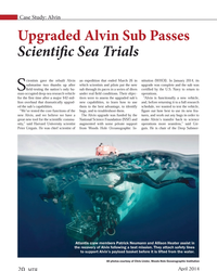
April 2014 - Marine Technology Reporter page: 20core functions of the new Alvin, and we believe we have a great new tool for the scientifi c commu- nity,” said Harvard University scientist Peter Girguis. He was chief scientist of an expedition that ended March 26 in which scientists and pilots put the new sub through its paces in a series of
-
 )
October 2000 - Maritime Reporter and Engineering News page: 46
)
October 2000 - Maritime Reporter and Engineering News page: 46. computer monitors mounted into a con- trol console that is adjacent to the exist- ing manual system. The control system's graphical user interface (GUI) was developed for Microsoft Windows 98/2000 technology. Having the two monitors side-by-side allows an opera- tor to view different elements
-
 )
March 2001 - Maritime Reporter and Engineering News page: 24
)
March 2001 - Maritime Reporter and Engineering News page: 24. There are also interesting options for navigation through the model in real time. The new kernel also includes a new graphic user interface (GUI) that is native to Microsoft Windows; that is to say that it is based on the intrinsic resources of the operating system and needs no emulation
-
 )
June 2001 - Maritime Reporter and Engineering News page: 3
)
June 2001 - Maritime Reporter and Engineering News page: 3or www.leica-geosystems.com/marine. "Destination: ESBJERG, ETA: 29 May, 2001 1145" se;W'W,, 5(m R0T: p°" lOVmin" /e" oTE VYPT MftV R'f GUI
-
 )
September 2002 - Maritime Reporter and Engineering News page: 30
)
September 2002 - Maritime Reporter and Engineering News page: 30of today. This has included the change from 2-D to 3- D CAD, a dramatic increase in the level of usability (example: from batch mode to fancy 3-D GUI's) and increased func- tionality within the tools themselves. With the development of these tools has also come improved integration of the CAD
-
 )
May 15, 1974 - Maritime Reporter and Engineering News page: 29
)
May 15, 1974 - Maritime Reporter and Engineering News page: 2936,000 lbs. Guaranteed steam flows & condition flange. The set will carry 1500 KW with steam conditior flange. The set will withstand 644 PSI and 850°F. Gui at exhaust flange: 50% Load — 750 KW — D.C 75% Load — 1125 KW — D.C 100% Load — 1500 KW — D.i Exhaust flange size: 18" x 38" rectangular.
-
 )
April 1972 - Maritime Reporter and Engineering News page: 2nd Cover
)
April 1972 - Maritime Reporter and Engineering News page: 2nd Coverof a series paying tribute to the great explorers of the sea. It is published in the interest of the shipping industry and those associated with it. GUI .FOIL TRADING COMPANY NEW YORK. N.Y. USA i
-
 )
February 1991 - Maritime Reporter and Engineering News page: 13
)
February 1991 - Maritime Reporter and Engineering News page: 13Asia-Pacific re- gion and Europe include building a 9,300-ton chemical tanker for Medi- terranean di Navigasionea, and a containership for a Papua New Gui- nea owner; conversion of two Kor- ean fishing vessels and upgrading an Australian fishing vessel. A spokesman for Singmarine said the group
-
 )
April 15, 1969 - Maritime Reporter and Engineering News page: 10
)
April 15, 1969 - Maritime Reporter and Engineering News page: 10meet-ing is the planning and execution of the program. In this case credit is given to Lt. Cmdr. Thomas A. Marnane, Charleston Naval Ship-yard, under whose guidance the en-tire affair was executed with ut-most precision. It was generally agreed that the two groups would make a practice of meeting togeth-er