Page 12: of Marine News Magazine (January 2011)
Vessel Construction & Repair
Read this page in Pdf, Flash or Html5 edition of January 2011 Marine News Magazine
 11
11
 13
13
very quickly, particularly in the early days of the response.
So we did find ourselves moving very quickly to establish new regions where we were detecting AIS.”
Rosenberger pointed to one example that he said spoke to some of the creativity that everyone involved in the response showed. “We were connected with one of the reconnaissance airplanes that was regularly doing flyovers of the area for oil sighting and other logistics activities. So we actually implemented an AIS receiver on board the air- craft. If you can imagine, an aircraft flying several thou- sand feet in the air has a pretty good blanket ability to receive VHF signals, which are AIS signals. So, as that air- craft was moving it allowed us to ingest additional vessel positions into the system that made it a more dynamic view — even further offshore where our land-based receivers don’t typically receive.” “The Deepwater Horizon incident hasn’t yet gone into a mode of looking historically at the data,” Rosenberger said. “That will come. If we look at some of the other inci- dents we’ve been involved in, at some point this will be of value so that when they’re paying claims associated with a boat that was put into service or taken out of service, you’d be able to verify the movements of that boat. You’d be able to see the activities that were performed and correlate that with invoicing or claims or other activities.”
Moving Forward with Business “There are other systems that show points on a map in real-time,” Rosenberg said. “We weren’t the first company to do that. But we really were the first company to allow users to derive business intelligence from that data.” “An example would be an oil refinery or marine termi- nal,” Rosenberg said, “which would gain near-perfect vis- ibility to all ship activity in and around their terminal and be able to better allocate resources.” The refinery or ter- minal would know when a ship arrives at a sea buoy, the status of pilots or harbor tugs and the location of a tow for tug and barge activity. “Because we were born out of the
Gulf of Mexico, we have paying users from almost every major oil company. Those companies are using PortVision for everything from logistic support, dispatch, market intelligence, chartering support, trading support, safety and security applications.”
Rosenberg said a relatively recent practice area for the company is support for legal cases. “We’re involved in about five legal cases every month, just from our clients and their lawyers asking for support around groundings, commercial disputes, collisions, allisions and other sorts of activities that occur, including demurrage related events.” “One of the ways we provide value is by maintaining an international network of AIS receivers. We currently have coverage in most regions of the U.S. and we’re in about 200 international regions.”
Rosenberg noted that the AIS technology that is required by international law, instead of being a burden, has actually been a bonus for maritime business. “Some of our customers comment that this doesn’t happen very often. A lot of times you see new regulations and you get a pit in your stomach. This is one case where those new regulations have driven new efficiencies and new oppor- tunities for the maritime community.” MN
INSIGHTS
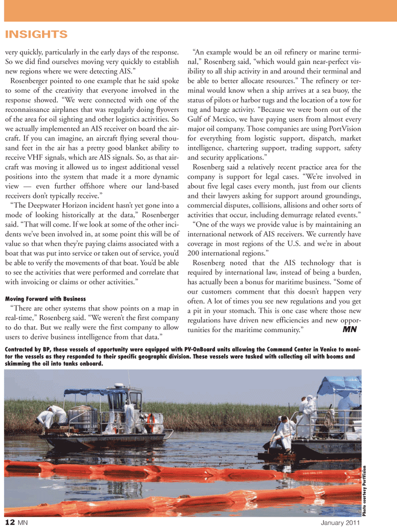
Contracted by BP, these vessels of opportunity were equipped with PV-OnBoard units allowing the Command Center in Venice to moni- tor the vessels as they responded to their specific geographic division. These vessels were tasked with collecting oil with booms and skimming the oil into tanks onboard.
Photo courtesy PortVision 12 MN January 2011