
Page 98: of Offshore Engineer Magazine (Apr/May 2013)
Read this page in Pdf, Flash or Html5 edition of Apr/May 2013 Offshore Engineer Magazine
 97
97
 99
99
AVOIDING SLIPPERY SLOPES
Fugro Uses Cutting-Edge Techniques to Optimize Pipeline Routes
William C. Haneberg and Brittany Bruce
Modeling Uncertainties
Fugro GeoConsulting, Inc.
To address these limitations, Fugro is incorporating
You need to plan an offshore pipeline route. How do quantitative map-based and GIS-compatible slope you best define your course? The shortest route stability models into its pipeline route planning. One would be a straight line from one terminus to the class of models—called rational probabilistic other, but that wouldn’t account for complications like models—combines physics-based evaluations of seafloor geohazards and infrastructure. Manually slope stability with randomly distributed input sketching a route that considers these constraints is a variables and elements of probability theory. This first step, but not nearly enough in today’s world of approach allows Fugro to incorporate natural complicated deepwater development projects that put variability and uncertainty into calculations and billions of dollars of capital at risk.
avoid the observational bias that can plague visual and qualitative interpretations. Results comprise a
Mapping Hazards map showing the probability of failure for a trigger
Take slope instability. Traditional qualitative slope such as a major earthquake with a specified failure maps (created by interpreting evidence of recurrence interval.
past slope failures) offer important information about seafloor geohazards that might affect pipeline routes.
The Optimal Solution
Failures with sharp edges and rough internal surfaces
Qualitative slope hazard maps and quantitative slope might be indicative of younger and potentially more stability models are combined with other datasets to hazardous events than those with rounded edges create a composite geocost map. Depending on the and smooth surfaces. Relative ages can sometimes project, the other data may include maps showing be improved by core sampling and dating. Even with fault scarps, pockmarks, active seafloor channels or absolute ages identified, however, empirical slope other geomorphological features; quantitative seafloor failure maps are limited in their ability to predict gradient, roughness and radius of curvature maps future failures.
(the latter being useful for predicting pipeline span potential); and cultural or biological maps.
This limitation is especially true when failure is triggered by a rare or unprecedented event. For
The route that accumulates the lowest total geocost is example, if a magnitude 4 earthquake had been the determined using GIS least-cost routing algorithms. largest to occur in recent geological history, it would
This corridor will surely be longer than the straight line be difficult to empirically infer, in any detail, the effects option, but in terms of geohazards encountered, it will of a magnitude 7 earthquake. also be less expensive.
The selected route will still need to be surveyed and analyzed in design-level detail. But now this work can be done with the confidence that the route was chosen using the best available methods and with a full appreciation of potential perils.
Author Information
William C. Haneberg, Ph.D., P.G., is a consultant and
Brittany Bruce is a project engineer and GIS analyst, both at Fugro GeoConsulting in Houston. They will offer a technical presentation on the same topic during this year’s Offshore Technology
Conference (OTC paper 23980).
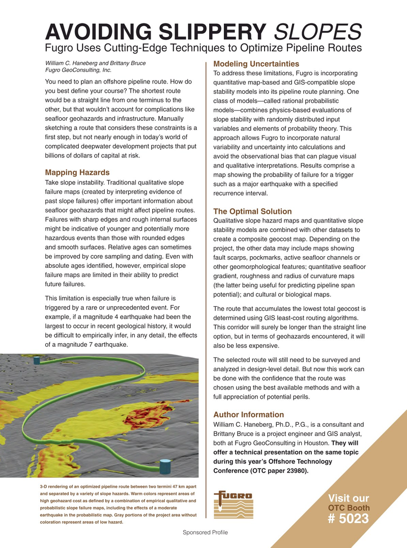
3-D rendering of an optimized pipeline route between two termini 47 km apart and separated by a variety of slope hazards. Warm colors represent areas of
Visit our high geohazard cost as defined by a combination of empirical qualitative and probabilistic slope failure maps, including the effects of a moderate
OTC Booth earthquake in the probabilistic map. Gray portions of the project area without # 5023 coloration represent areas of low hazard.
Sponsored Profle