
Page 22: of Offshore Engineer Magazine (Dec/Jan 2013)
Read this page in Pdf, Flash or Html5 edition of Dec/Jan 2013 Offshore Engineer Magazine
 21
21
 23
23
FRONTIERS
Understanding the ice environment is critical to Arctic success
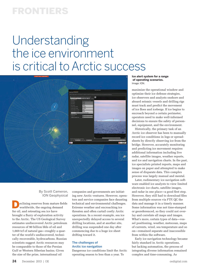
Ice alert system for a range of operating scenarios.
Image: ION. maximize the operational window and optimize their ice defense strategies, ice observers and analysts onshore and aboard seismic vessels and drilling rigs must track and predict the movement of ice foes and icebergs. If ice begins to encroach beyond a certain perimeter, operators need to make well-informed decisions to ensure the safety of person- nel, equipment, and the environment.
Historically, the primary task of an
Arctic ice observer has been to manually record ice conditions in logs or spread- sheets by directly observing ice from the bridge. However, accurately monitoring and predicting ice movement requires additional information including live radar, satellite images, weather reports, and ice and navigation charts. In the past, ice specialists printed reports, maps and images on paper and attempted to make sense of disparate data. This complex process was largely manual and mental.
Later, rudimentary ice navigation soft- ware enabled ice analysts to view limited electronic ice charts, satellite images,
By Scott Cameron, companies and governments are initiat- and radar in one place—a good frst step. ing new Arctic ventures. However, opera- However, they still had to download fles
ION Geophysical tors and service companies face daunting from multiple sources via FTP, QC the eclining reserves from mature felds technical and environmental challenges. data and manage it in a timely manner.
D worldwide, the ongoing demand Extreme weather and encroaching ice Some information was not time-stamped for oil, and retreating sea ice have threaten and often curtail costly Arctic or georeferenced, so they could not over- brought a furry of exploration activity operations. In a recent example, sea ice lay and correlate all maps and images. to the Arctic. The US Geological Survey unexpectedly delayed access to several What’s more, certain types of data—ves- estimates undiscovered Arctic petroleum drilling locations, and at another site, sel positioning, weather, metocean, maps resources of 90 billion bbls of oil and drilling was suspended one day after of currents, wind, sea temperature and so 1,669 tcf of natural gas—roughly a quar- commencing due to a huge ice sheet on—remained separate and inaccessible ter of the world’s undiscovered, techni- drifting toward it. from within the software. cally recoverable, hydrocarbons. Russian Early ice navigation technology became
The challenges of scientists suggest Arctic resources may fairly standard in Arctic operations,
Arctic ice navigation be comparable to those of the Persian but lacking automation, the process of
Gulf or Western Siberian basins. Given Dangerous ice conditions limit the Arctic integrating diverse information remained the size of the prize, international oil operating season to less than a year. To complex and time-consuming. As
December 2013 | OE oedigital.com 24 024_OE1213_Frontier3.indd 24 11/22/13 3:49 PM