
Page 24: of Offshore Engineer Magazine (Dec/Jan 2013)
Read this page in Pdf, Flash or Html5 edition of Dec/Jan 2013 Offshore Engineer Magazine
 23
23
 25
25
FRONTIERS products. In addition, observers manually entered information about ice fragments known as “bergy bits” and “growlers” that were too small to show up on ice data products. Plotting their loca- tion, speed, and direction, analysts used Narwhal’s time-slide ani- mations to predict where the ice would move in the coming days.
Personnel working in hazardous areas specifed by a pre-set alarm perimeter could proactively move elsewhere until it was clear again, ensuring safe and effcient deploy- ment of costly resources.
Although it had been installed originally as a secondary ice
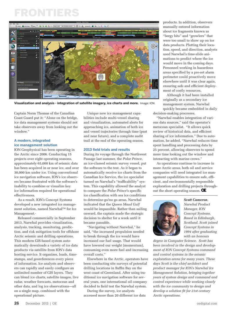
Visualization and analysis - integration of satellite imagery, ice charts and more. Image: ION. management system, Narwhal quickly became embedded in daily
Captain Norm Thomas of the Canadian Unique new ice management capa- decision-making processes.
Coast Guard put it: “Alone on the bridge, bilities include multi-vessel sharing “Narwhal enables integration of vari- ice data management systems should not and visualization, automated alerts for ous data sources,” said the operator’s take observers away from looking out the approaching ice, animation of both ice metocean specialist. “It allows quick window.” and vessel trajectories through time (past review of historical data, and effcient and near future), and a complete audit sharing of ice information.” Due to auto-
A modern, integrated trail at the end of the operating season. mation, he added, “Narwhal reduces time ice management solution spent handling and processing data by
ION Geophysical has been operating in 25 percent, allowing observers to spend 2013 feld trials and results the Arctic since 2006. Conducting 15 During its voyage through the Northwest more time looking out the window and projects over eight operating seasons, Passage last summer, the Polar Prince, interacting with marine crews.” approximately 65,000 km of seismic data an ice-classed seismic survey vessel, put As operations continue to increase in has been acquired in or near ice, and over the software to the test. As it began to more Arctic areas, both oil and service 30,000 km under ice. Using conventional automatically receive ice charts from the companies will need integrated ice man- ice navigation software, ION’s ice observ- Canadian Ice Service, the ice specialist agement capabilities to ensure safe, eff- ers became frustrated with the software’s turned on Narwhal’s “traffcability” sys- cient, and environmentally responsible inability to combine or visualize key tem. This capability allowed the analyst exploration and drilling projects through- ice information required for operational to compare the Polar Prince’s specifc out the short operating season. effectiveness. ice classifcation with sea ice conditions
As a result, ION’s Concept Systems to determine go/no go areas. Narwhal Scott Cameron, developed a new integrated ice manage- indicated that the Queen Maud Gulf Narwhal Product ment solution, named Narwhal™ for Ice would be impassible. Rather than sailing Manager, ION
Management. onward, the captain made the strategic Concept Systems.
Released commercially in September decision to shelter for a week until it Based in Edinburgh, 2013, Narwhal provides visualization, became passable. Scotland, Scott joined analysis, tracking, monitoring, predic- “Navigating without Narwhal,” he Concept Systems in tion, and risk mitigation tools for offshore said, “the increased propulsion needed 1994 after graduating
Arctic seismic and drilling operations. to break through the ice would have with an honours
This modern GIS-based system auto- increased our fuel usage. That would degree in Computer Science. Scott has matically downloads a variety of ice data have lowered our weight (momentum), been involved in the design and develop- products via satellite from ION’s data consuming even more fuel and increasing ment of ION Concept Systems command hosting service. It organizes, loads, time- overall costs.” and control systems in the seismic stamps, and georeferences every piece Elsewhere in the Arctic, operators have exploration arena for many years. These of information. Ice analysts and observ- been conducting site surveys of potential days Scott is the chief architect and ers can rapidly and easily confgure an drilling locations in Baffn Bay on the product manager for ION’s Narwhal Ice unlimited number of GIS layers. They west coast of Greenland. After using tra- Management Solution, bringing together can blend ice charts, satellite images, live ditional ice navigation software for sev- years of system design and command and radar, weather forecasts, metocean and eral years, one international oil company control experience while working closely other data, and log ice observations—all decided to feld test the Narwhal system. with the ice community to design and on a single map, combined with the During the survey, ice analysts develop a solution ft for 21st century operational picture. accessed more than 20 different ice data Arctic operations.
December 2013 | OE oedigital.com 26 024_OE1213_Frontier3.indd 26 11/22/13 3:45 PM