
Page 28: of Offshore Engineer Magazine (Dec/Jan 2013)
Read this page in Pdf, Flash or Html5 edition of Dec/Jan 2013 Offshore Engineer Magazine
 27
27
 29
29
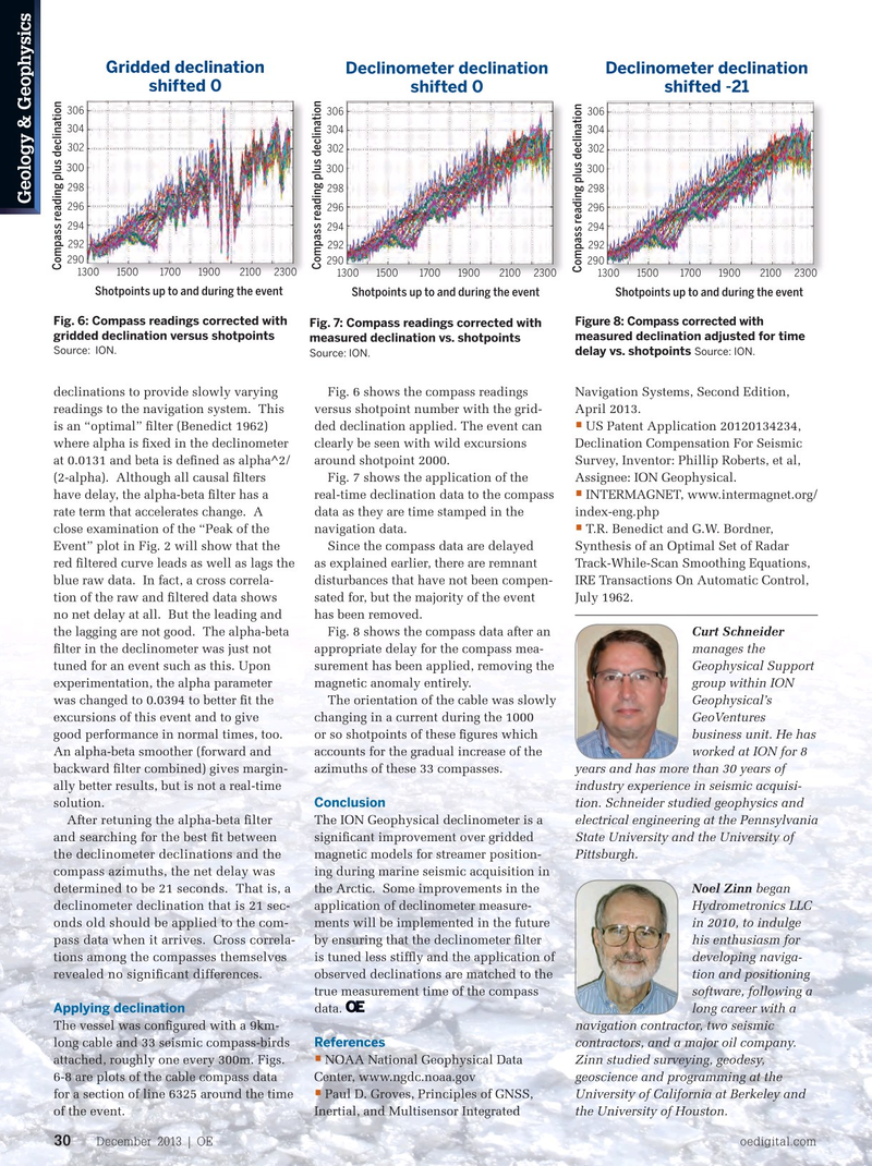
Gridded declination Declinometer declination Declinometer declination shifted 0 shifted 0 shifted -21 306 306 306 304 304 304 302 302 302 300 300 300 298 298 298
Geology & Geophysics 296 296 296 294 294 294 292 292 292 290 290 290
Compass reading plus declination
Compass reading plus declination
Compass reading plus declination 1300 1500 1700 1900 2100 2300 1300 1500 1700 1900 2100 2300 1300 1500 1700 1900 2100 2300
Shotpoints up to and during the event Shotpoints up to and during the event Shotpoints up to and during the event
Fig. 6: Compass readings corrected with
Figure 8: Compass corrected with
Fig. 7: Compass readings corrected with gridded declination versus shotpoints measured declination adjusted for time measured declination vs. shotpoints
Source: ION.
Source: ION.
delay vs. shotpoints
Source: ION.
declinations to provide slowly varying Fig. 6 shows the compass readings Navigation Systems, Second Edition, readings to the navigation system. This versus shotpoint number with the grid- April 2013.
• is an “optimal” flter (Benedict 1962) ded declination applied. The event can US Patent Application 20120134234, where alpha is fxed in the declinometer clearly be seen with wild excursions Declination Compensation For Seismic at 0.0131 and beta is defned as alpha^2/ around shotpoint 2000. Survey, Inventor: Phillip Roberts, et al, (2-alpha). Although all causal flters Fig. 7 shows the application of the Assignee: ION Geophysical.
• have delay, the alpha-beta flter has a real-time declination data to the compass INTERMAGNET, www.intermagnet.org/ rate term that accelerates change. A data as they are time stamped in the index-eng.php • close examination of the “Peak of the navigation data. T.R. Benedict and G.W. Bordner,
Event” plot in Fig. 2 will show that the Since the compass data are delayed Synthesis of an Optimal Set of Radar red fltered curve leads as well as lags the as explained earlier, there are remnant Track-While-Scan Smoothing Equations, blue raw data. In fact, a cross correla- disturbances that have not been compen- IRE Transactions On Automatic Control, tion of the raw and fltered data shows sated for, but the majority of the event July 1962.
no net delay at all. But the leading and has been removed.
the lagging are not good. The alpha-beta Fig. 8 shows the compass data after an Curt Schneider flter in the declinometer was just not appropriate delay for the compass mea- manages the tuned for an event such as this. Upon surement has been applied, removing the Geophysical Support experimentation, the alpha parameter magnetic anomaly entirely. group within ION was changed to 0.0394 to better ft the The orientation of the cable was slowly Geophysical’s excursions of this event and to give changing in a current during the 1000 GeoVentures good performance in normal times, too. or so shotpoints of these fgures which business unit. He has
An alpha-beta smoother (forward and accounts for the gradual increase of the worked at ION for 8 backward flter combined) gives margin- azimuths of these 33 compasses. years and has more than 30 years of ally better results, but is not a real-time industry experience in seismic acquisi-
Conclusion solution. tion. Schneider studied geophysics and
After retuning the alpha-beta flter
The ION Geophysical declinometer is a electrical engineering at the Pennsylvania and searching for the best ft between signifcant improvement over gridded State University and the University of magnetic models for streamer position- Pittsburgh. the declinometer declinations and the compass azimuths, the net delay was ing during marine seismic acquisition in the Arctic. Some improvements in the Noel Zinn began determined to be 21 seconds. That is, a declinometer declination that is 21 sec- application of declinometer measure- Hydrometronics LLC onds old should be applied to the com- ments will be implemented in the future in 2010, to indulge by ensuring that the declinometer flter his enthusiasm for pass data when it arrives. Cross correla- tions among the compasses themselves is tuned less stiffy and the application of developing naviga- observed declinations are matched to the tion and positioning revealed no signifcant differences.
true measurement time of the compass software, following a
Applying declination data. long career with a
The vessel was confgured with a 9km- navigation contractor, two seismic
References long cable and 33 seismic compass-birds contractors, and a major oil company. • attached, roughly one every 300m. Figs. NOAA National Geophysical Data Zinn studied surveying, geodesy, 6-8 are plots of the cable compass data Center, www.ngdc.noaa.gov geoscience and programming at the • for a section of line 6325 around the time Paul D. Groves, Principles of GNSS, University of California at Berkeley and of the event. Inertial, and Multisensor Integrated the University of Houston.
December 2013 | OE oedigital.com 30 028_1213_G&G- ION.indd 30 11/22/13 4:20 PM