
Page 48: of Offshore Engineer Magazine (Feb/Mar 2014)
Read this page in Pdf, Flash or Html5 edition of Feb/Mar 2014 Offshore Engineer Magazine
 47
47
 49
49
Australasia
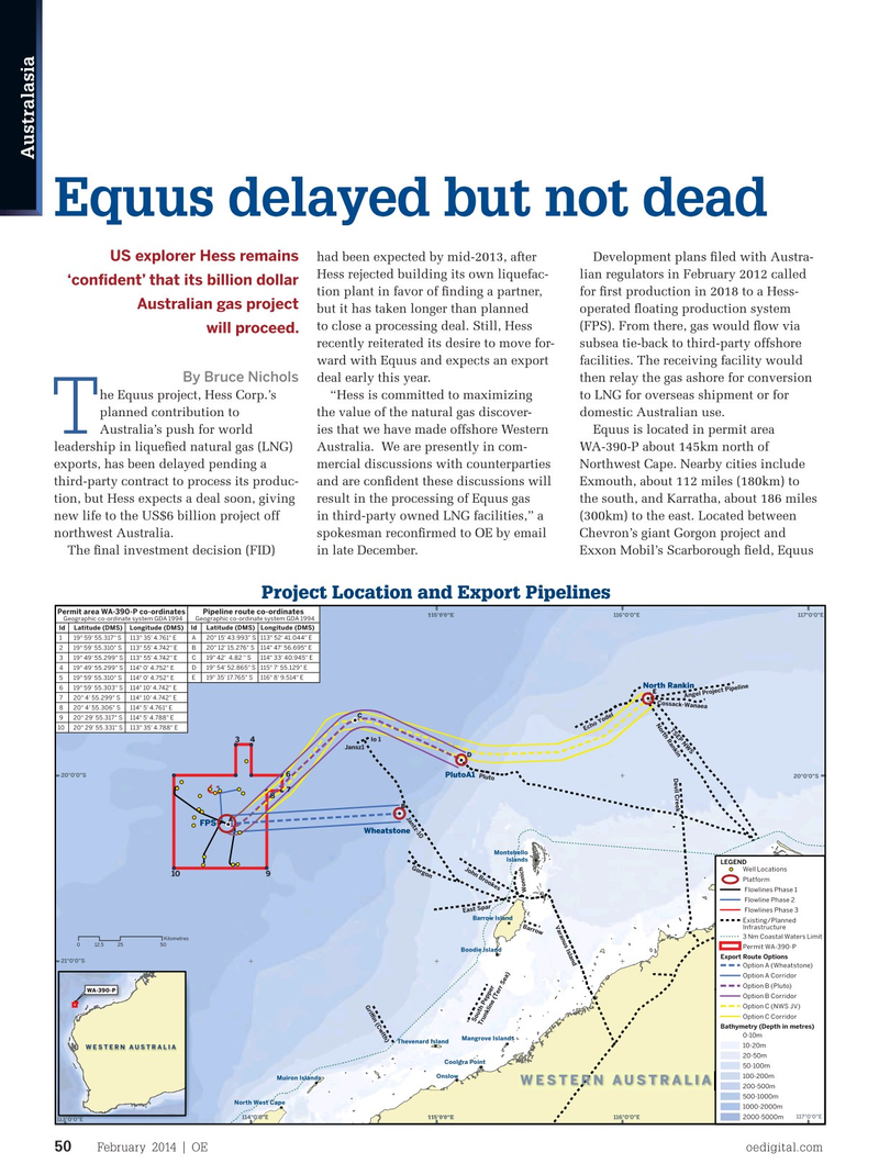
Equus delayed but not dead had been expected by mid-2013, after Development plans ? led with Austra-
US explorer Hess remains
Hess rejected building its own liquefac- lian regulators in February 2012 called ‘con? dent’ that its billion dollar tion plant in favor of ? nding a partner, for ? rst production in 2018 to a Hess-
Australian gas project but it has taken longer than planned operated ? oating production system to close a processing deal. Still, Hess (FPS). From there, gas would ? ow via will proceed.
recently reiterated its desire to move for- subsea tie-back to third-party offshore ward with Equus and expects an export facilities. The receiving facility would
By Bruce Nichols deal early this year. then relay the gas ashore for conversion he Equus project, Hess Corp.’s “Hess is committed to maximizing to LNG for overseas shipment or for planned contribution to the value of the natural gas discover- domestic Australian use.
T
Australia’s push for world ies that we have made offshore Western Equus is located in permit area leadership in lique? ed natural gas (LNG) Australia. We are presently in com- WA-390-P about 145km north of exports, has been delayed pending a mercial discussions with counterparties Northwest Cape. Nearby cities include third-party contract to process its produc- and are con? dent these discussions will Exmouth, about 112 miles (180km) to tion, but Hess expects a deal soon, giving result in the processing of Equus gas the south, and Karratha, about 186 miles new life to the US$6 billion project off in third-party owned LNG facilities,” a (300km) to the east. Located between northwest Australia. spokesman recon? rmed to OE by email Chevron’s giant Gorgon project and
The ? nal investment decision (FID) in late December. Exxon Mobil’s Scarborough ? eld, Equus
Project Location and Export Pipelines
Pipeline route co-ordinates
Permit area WA-390-P co-ordinates 116°0'0"E 117°0'0"E 115°0'0"E
Geographic co-ordinate system GDA 1994 Geographic co-ordinate system GDA 1994
Id Latitude (DMS) Longitude (DMS) Id Latitude (DMS) Longitude (DMS) 119° 59' 55.317" S113° 35' 4.761" E A20° 15' 43.993" S113° 52' 41.044" E 219° 59' 55.310" S113° 55' 4.742" E B20° 12' 15.276" S114° 47' 56.695" E 319° 49' 55.299" S113° 55' 4.742" E C19° 42' 4.82 " S114° 33' 40.945" E 419° 49' 55.299" S114° 0' 4.752" E D19° 54' 52.865" S115° 7' 55.129" E 519° 59' 55.310" S114° 0' 4.752" E E19° 35' 17.765" S116° 8' 9.514" E
North Rankin 619° 59' 55.303" S114° 10' 4.742" E
E
Angel Project Pipeline 720° 4' 55.299" S114° 10' 4.742" E
Cossack-Wanaea 820° 4' 55.306" S114° 5' 4.761" E
C 920° 29' 55.317" S114° 5' 4.788" E
North Rankin 10 20° 29' 55.331" S113° 35' 4.788" E
TSEP NWS
Echo Yodel
Io 1 4 3
Jansz1
D 6 20°0'0"S
PlutoA1
Pluto 20°0'0"S
Devil Creek 7 8
B
Jantz-10
A
FPS
Wheatstone
Montebello
Islands
LEGEND
Gorgon
John Brookes
Well Locations 10 9
Platform
Flowlines Phase 1
Wonnich
Flowline Phase 2
Flowlines Phase 3
East Spar
Barrow Island
Existing/Planned
Varanus Island
Barrow
Infrastructure 3 Nm Coastal Waters Limit
Kilometres 12.5 0 25 50
Permit WA-390-P
Boodie Island
Export Route Options 21°0'0"S
Option A (Wheatstone)
Option A Corridor
Option B (Pluto)
WA-390-P
Option B Corridor
Gri‰n (Cwlth)
Option C (NWS JV)
Option C Corridor
South Pepper
Trunkline (Terr Sea)
Bathymetry (Depth in metres) 0-10m
Mangrove Islands
Thevenard Island 10-20m
WESTERN AUSTRALIA 20-50m
Coolgra Point 50-100m
Onslow 100-200m
Muiron Islands
WESTERN AUSTRALIA 200-500m 500-1000m
North West Cape 1000-2000m 117°0'0"E 114°0'0"E 116°0'0"E115°0'0"E 2000-5000m 113°0'0"E
February 2014 | OE oedigital.com 50 050_OE0214Geofocus1.indd 50 1/20/14 10:10 PM