
Page 21: of Offshore Engineer Magazine (Jan/Feb 2015)
Read this page in Pdf, Flash or Html5 edition of Jan/Feb 2015 Offshore Engineer Magazine
 20
20
 22
22
Fig.3
Fig.4
Fig.5.
Fig.6/a
Analysis
Current
The weather conditions west of complexities
Shetland are some of the harshest in the world, even without the help of hurricanes, typhoons and squalls. Elaine
Maslin reports on how some companies are attempting to better understand the region.
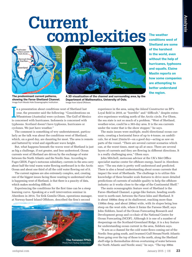
The predominant current patterns, A 3D visualization of the channel and surrounding area, by the showing the Faroe-Shetland Channel. Department of Mathematics, University of Oslo.
Image from Woods Hole Oceanographic Institution. Image from Island Ofshore. n a presentation about conditions west of Shetland last experience in the area, using the Island Constructor on BP’s year, the presenter said the following: “Considerations on Loyal feld in 2010, as “horrible” and “diffcult,” despite exten-
I
Wheatstone (Australia) were cyclones. The Gulf of Mexico sive experience working north of the Arctic circle. For Olsen, is concerned with hurricanes. Indonesia is concerned with the sea state is not so much of a problem. “West of Shetland, typhoons. Scotland doesn’t have typhoons, hurricanes or weather-wise, could be a 365-day area. It is the sea currents cyclones. We just have weather.” under the water that is the show stopper,” he says.
The comment is something of wry understatement, particu- The main issues were multiple, multi-directional ocean cur- larly as the talk was about the conditions west of Shetland, rents, creating a horizontal force of up to 4-tonne, on umbili- which, on a good day, are daunting for most. The area is remote cals, for at least 25min/d—on a good day—acting as saw on and battered by wind and signifcant wave height. parts of the vessel. “There are several current scenarios which
But, what happens beneath the waves west of Shetland is just can, at the worst times, meet up all at once. There are several
Ocean as big a challenge, if not greater, and less understood. layers of currents and they are fowing in different directions. It water currents west of Shetland are driven by the exchange of is a really challenging area,” Olsen says. between the North Atlantic and the Nordic Seas. According to
John Mitchell, metocean advisor at the UK’s Met Offce
Fugro GEOS, Fugro’s metocean subsidiary, currents in the area carry specialist marine center for offshore energy, based in Aberdeen about half the total warm water fowing northward in to the Arctic says: “The sea state is pretty well understood and predicted.
Ocean and about one third of all the cold water fowing out of it.
There is also a broad understanding about ocean currents that
The current regimes are also extremely complex, and, creating impact the west of Shetlands. The challenge is to utilize this one of the biggest issues facing those wanting to understand what knowledge of these broader scale features to drive more detailed is happening west of Shetland, is that there is a paucity of data, predictions of currents of suitable quality to help the offshore which makes modeling diffcult. industry as it works close to the edge of the Continental Shelf.”
Experiencing the conditions for the frst time can be a steep The main oceanographic feature west of Shetland is the learning curve. Speaking at a well intervention seminar in Faroe–Shetland Channel, a gorge-like feature, heading south-
Aberdeen in 2014, Tor Erik Grønlie Olsen, operations manager, west to north-east, between the Faroe Isles and Shetland. It at Norway-based Island Offshore, described the frm’s second is about 1000m deep at its shallowest, reaching more than 1500m deep, and about 200mi wide, with its slopes being less steep on the west side, where it forms the Faroese Shelf, says
John Siddorn, head of the Ocean Forecasting Research and
Development group and co-chair of the National Centre for
Ocean Forecasting (NCOF). Although it is one of a number of deepenings on the Scotland-Greenland Ridge, it is a key feature for understanding ocean current in the area, Siddorn says. “It acts as a channel for the cold water fows coming out of the
Nordic Seas going south, and (warmer) Gulf Stream/North Atlantic fows going over the top of those to the north, along the Shetland
The Foinaven FPSO. shelf edge (a thermohaline driven overturning of water between
Photo from Teekay Corporation.
the North Atlantic and Nordic seas),” he says. “The top 300m oedigital.com January 2015 | OE 23 023_OE0115_analysis.indd 23 12/22/14 5:16 PM