Martin De Kievit
-
- D-Day Mapping Mission Marine Technology, Mar 2014 #56
It’s been almost 70 years since the invasion of Normandy, France when 156,000 Allied troops landed and began their march across Europe to defeat Hitler. And, while these soldiers’ collective destinies could not have been known at the time, their will to fight was unmistakable. General Dwight D. Eisenhower called the D-Day operation a crusade in which “we will accept nothing less than full victory.” The allied troops heard this charge and proved their resolve. The D-Day cost was high — more than 9,000 Allied soldiers were killed or wounded — but on Tuesday, June 6, 1944 more than 100,000 soldiers gained a crucial foothold in Normandy. (Source: D-Day - June 6, 1944 - the United States Army).
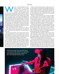
On D-Day and the days following, a 50-mile stretch of French coastline was overtaken by man and machine. In total there were 170,000 vehicles and 5,000-plus ships, including 702 war ships. The beaches of Normandy no doubt have a story to tell.
To honor those who served, a massive survey and archeological effort is underway sponsored by France Televisions, 13 other broadcasters and the Normandy region. The French Navy (Marine National) and Department of Underwater and Undersea Archeological Research (DRASSM) were involved as well. Involvement from Sherrell Ocean Services, Trimble Navigation, Ltd. and Measutronics Corporation, a Trimble authorized marine dealer, was also instrumental in making this expedition possible. Each company involved is committed to the effort and is graciously donating their time, equipment and expertise to the project. Covering approximately 500 square kilometers, this will be the largest continuous survey of this type ever completed in the region. Together, these groups are building a complete GIS database of the area based around the five invasion beaches of D-Day. The volunteers are sharing their professional expertise to preserve the Normandy beaches’ history as well as capture 3D images of the historic assets.
Through their survey and mapping work, the team is working to have the Normandy D-Day invasion coastline designated as a UNESCO World Heritage Site by the World Heritage Committee. A UNESCO World Heritage Site is a location that is identified as having special cultural or physical significance, not to a single nation, but to the world.
Beaches of Normandy - Survey
The Discovery Phase of the mapping expedition started in July 2013 with a catamaran and crew leaving from Port of Saint-Malo, France. The total survey effort took nearly seven weeks and involved bathymetric mapping with an EdgeTech interferometric multibeam / side scan sonar combined with the Trimble SPS855/555H GNSS modular heading bundle and an inertial motion reference unit (MRU). The Trimble SPS heading bundle outputs the position, heading and timing synchronization data to the multibeam data collection and processing software. Here it is stored and time-tagged to the sonar data. Geo-referenced point cloud and side scan data are displayed real time for review by the system operator as well as logged for further data editing, processing and mapping.
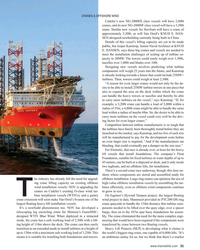
The Trimble SPS series heading bundle antenna array was mounted on center with the transducer mount pole near the bow of the catamaran vessel. A custom mount was developed and built to allow the entire survey sensor package to be retracted when entering or departing local ports, which have limited hull clearances, dependent upon tides. The interferometric sonar system afforded wide swath “point cloud” coverage for three-dimensional modeling and also provided side scan planimetric imagery to aid in target identification.
Measutronics Corporation, Trimble’s leading U.S. Marine dealer, was chosen for this project because of its experience in the field of marine guidance, mapping, imaging and equipment holdings. Lou Nash, Measutronic’s founder, explains that the GNSS heading bundle is critical to the bathymetric systems because, “without accurate positioning, you essentially don’t have a reference point or know where you are in relation to anything else; as a result you can’t accurately and efficiently trace back to targets in the water. In addition, the ‘motion of the ocean’ must be accounted for as all the sounding and image data collected are done so from a constantly moving platform – subject to the effects of vessel heave, pitch and roll.”
The Trimble SPS855 site positioning heading bundle was selected because of its accuracy and it’s interoperability with Fugro Marinestar satellite-based correction signals as well as shore-based reference stations. The SPS series heading bundle is also interoperable with a number of motion reference units (MRU). With inputs from the heading bundle receivers, the MRU provided a blended GNSS / inertial solution, compensating for the effects of heave, pitch and roll. The Marinestar correction service was chosen over land-based correction transmission stations as typical UHF radio transmission would have required increased logistics and would not have provided adequate coverage for a large portion of the offshore due to the extreme distances involved.
“We chose the Trimble receiver because it’s really the only modular receiver that delivers the flexibility, accuracy and performance that we needed on a marine mapping expedition as significant as this,” said Nash. “It tracks the full GNSS constellation, giving better positioning availability and high precision, plus our crew knows the equipment inside and out.”
Target Identification Phase
In mid-August the crew began to focus on further development of targets of interest identified during the previous weeks of surveying. Now mobilizing from Cherbourg, France, efforts included the use of SeaBotix remotely operated vehicles (ROVs) fitted with Tritech acoustic tracking devices and sonar. These efforts were used to prioritize those targets to be further developed / examined with a higher resolution multibeam sonar system. For the remainder of the survey, crews use the SeaBotix ROVs and a video camera along while continuing to collect multibeam data.
High-Interest Targets
For high resolution point cloud data collection, an R2Sonic 2024 Ultra High Resolution (UHR) mulitibeam sonar was used. With the ultra-high resolution sonar system, the crew collected high-resolution point cloud data for about 20 historic assets of particular interest.
As a further effort in providing the most accurate point cloud data possible, GNSS phase data and inertial data were collected and logged with an Applanix POS MV motion reference unit. Data were then post processed with Applanix’s POSPac MMS software providing a “true heave” blended GNSS / inertial solution. The post processed data files were then read into a hydrographic survey software package. Martin de Kievit, business development manager for Trimble Marine in the Heavy Civil Construction division, explains that the survey software grabs input from the GNSS receiver where it allows for display and editing of track lines, sounding profiles and text data. The software system correlates time-tagged tide, vessel position, motion and sound velocity correction data which are used to accurately plot and record locations.
“Our surveys reported some 300 targets [artifacts] and about 20 ‘new’ wreckage sites were more fully developed,” said Nash.
As submerged targets of interest were more fully developed and accurately located, crews also launched small manned submarines to capture film footage of various high-profile wreckage sites. Led by Andy Sherrell of Sherrell Ocean Services, the crew filmed sites in order to capture color and details of what the servicemen may have faced on that fateful June day. Using video, sonar, 3D imagery and 3D visualizations, the crew is essentially “peeling back the water to bring these stories to life,” Nash added.
With higher resolution images and precise point cloud data, the crew is hoping to determine the actual ship, aircraft or vehicle name of the artifacts revealed. With this information, historians will also endeavor to derive names, ranks and associations of the crewmembers that were aboard the vessels or vehicles when they were sunk and destroyed.
Updating the GIS Database
During the months to come, teams will continue to work with the massive 11TB data set. The United Kingdom Hydrographic Office (UKHO) and the French nautical charting authority (SHOM) are collaborating in an effort to update the international wreck database for the area. Because a large percentage of these identified artifacts are newly discovered or were inaccurately positioned previously, the team is working to make these corrections before they deliver the complete survey data to the UNESCO World Heritage Committee for review. To commemorate the event, MC4 and LCL Production are producing a 90-minute documentary for the international market. PBS/Nova will broadcast an adaptation in North America, both to be aired memorializing the 70th anniversary.
Honoring Those Who Were There on “The Longest Day”
During the official 70th Anniversary D-Day ceremony scheduled for June 2014, veterans, dignitaries and archeologists will meet along this historic coast to honor those who have served and sacrificed. Led by the French Department of Underwater Archeological Research, manned submarines will also escort a handful of WWII veterans and historians underwater to investigate a few of the high-profile identified wrecks.
“Nearly everyone we approached about providing support for this historic mapping expedition, by means of donating equipment or personnel, was extremely supportive and enthusiastic about the project,” said Nash. “Everyone has considered it an honor to be involved in this effort, and I know I feel that way, as do our guys.”
(As published in the March 2014 edition of Marine Technology Reporter - www.seadiscovery.com)
-
 )
March 2024 - Marine Technology Reporter page: 48
)
March 2024 - Marine Technology Reporter page: 48Index page MTR MarApr2024:MTR Layouts 4/4/2024 3:19 PM Page 1 Advertiser Index PageCompany Website Phone# 17 . . . . .Airmar Technology Corporation . . . . . . . . . .www.airmar.com . . . . . . . . . . . . . . . . . . . . . . . . . . . . . . . . .(603) 673-9570 9 . . . . . .Birns, Inc. . . . . . . . . . .
-
 )
March 2024 - Marine Technology Reporter page: 46
)
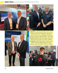
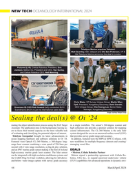
March 2024 - Marine Technology Reporter page: 46NEW TECH OCEANOLOGY INTERNATIONAL 2024 MTR TV’s professional video team was out and about at Oi in London for nearly 20 executive interviews, including [clockwise, starting top left]: Cellula Robotics’ CEO Neil Manning; Rob Dewell, Integration Engineer, Saab UK who put the new eM1-7 electric manipulator
-
 )
March 2024 - Marine Technology Reporter page: 45
)
March 2024 - Marine Technology Reporter page: 45ronments. The new agreement will address speci? c techni- cal gaps in the UUV defense and offshore energy markets especially for long duration, multi-payload mission opera- tions where communications are often denied or restricted. As part of the new alliance, Metron’s Resilient Mission Autonomy portfolio
-
 )
March 2024 - Marine Technology Reporter page: 44
)
March 2024 - Marine Technology Reporter page: 44, President, Eric Jackson, Metron Inc. President and CEO, Van Gurley, and Cellula Robotics CEO, Neil Manning. Chris Blake, VP Survey, Unique Group; Martin Wien Fjell, President, Kongsberg Discovery; Sahil Gandhi, CEO Unique Group; Che Keong Lee, Senior Sales Greensea IQ CGO Rob Howard (left) contracted
-
 )
March 2024 - Marine Technology Reporter page: 36
)
March 2024 - Marine Technology Reporter page: 36LANDER LAB #10 Of special interest for marine applications, LiPo batteries are Shipping any kind of lithium battery can be a challenge, and offered in a “pouch” design, with a soft, ? at body. The pouch IATA regs vary with the batteries inside or outside an instru- is vacuum-sealed, with all voids ?
-
 )
March 2024 - Marine Technology Reporter page: 33
)
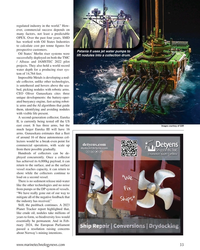
March 2024 - Marine Technology Reporter page: 33regulated industry in the world.” How- ever, commercial success depends on many factors, not least a predictable OPEX. Over the past four years, SMD has worked with Oil States Industries to calculate cost per tonne ? gures for prospective customers. Patania II uses jet water pumps to Oil States’
-
 )
March 2024 - Marine Technology Reporter page: 27
)
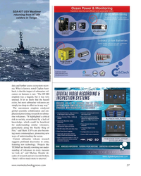
March 2024 - Marine Technology Reporter page: 27SEA-KIT USV Maxlimer returning from HT-HH caldera in Tonga. © SEA-KIT International data and further assess ecosystem recov- ery. What is known, noted Caplan-Auer- bach, is that the impact of submarine vol- canoes on humans is rare. “The HT-HH eruption was a tragedy, but it was very unusual. It let us
-
 )
March 2024 - Marine Technology Reporter page: 15
)
March 2024 - Marine Technology Reporter page: 15Slocum Glider at Teledyne Webb acoustic sensors, on-board processing, and imaging hardware Research. Quinn came to Teledyne Webb Research from Lockheed Martin. He simultaneously for months at a time, extending deployments earned his Bachelor of Science in Electrical even in remote locations like the Antarctic
-
 )
March 2024 - Marine Technology Reporter page: 11
)
March 2024 - Marine Technology Reporter page: 11assist in identifying mines and act as a neutralization device. About the Author Bottom mines pose even greater chal- David R. Strachan is a defense analyst and founder of lenges. Unlike contact mines, bottom Strikepod Systems, a research and strategic advisory mines utilize a range of sensors to
-
 )
March 2024 - Marine Technology Reporter page: 6
)
March 2024 - Marine Technology Reporter page: 6issues. Quinn Shea Quinn is the Product Line Manager of the Slocum Glider at Teledyne Webb Research. Quinn came to Teledyne Webb Research from Lockheed Martin. He earned his Bachelor of Science in Electrical Engineering and Mechatronics at Villanova University and a Master of Engineering in Systems Engineering
-
 )
April 2024 - Maritime Reporter and Engineering News page: 35
)
April 2024 - Maritime Reporter and Engineering News page: 35SIMULATION e have a close relationship with tech- Realism is prized beyond immersive, photo-realistic visu- nology, evidenced by, for example, als, and providers are introducing increasingly accurate func- the phones we are estimated to un- tionality. FORCE Technology’s upcoming DEN-Mark2 math- lock around
-
 )
April 2024 - Maritime Reporter and Engineering News page: 31
)
April 2024 - Maritime Reporter and Engineering News page: 31CRANES & OFFSHORE WIND Cadeler’s new NG-20000X class vessels will have 2,600t cranes, and its new NG-20000F class vessel will have a 3,200t crane. Similar new vessels for Havfram will have a crane of approximately 3,200t, as will Van Oord’s KNUD E. HAN- SEN-designed newbuilding currently being built in
-
 )
April 2024 - Maritime Reporter and Engineering News page: 21
)
April 2024 - Maritime Reporter and Engineering News page: 21ROB LANGFORD, VP, GLOBAL OFFSHORE WIND ob Langford has worked in the offshore industry ABS. “We are growing and evolving our services across all for more than three decades, ‘cutting his teeth’ offshore infrastructure along with our continued support to the in a UK design ? rm working in the North Sea
-
 )
April 2024 - Maritime Reporter and Engineering News page: 14
)
April 2024 - Maritime Reporter and Engineering News page: 14Book Review Approach to Meeting Underwater Radiated Noise Limits Def ned By Raymond Fischer uantitative underwater radiated noise limits will construction inspections, 5) possible training with respect to be developed shortly by IMO, and/or countries salient design/construction essentials, 6) compliance
-
 )
April 2024 - Maritime Reporter and Engineering News page: 4
)
April 2024 - Maritime Reporter and Engineering News page: 4van Hemmen Fischer Eero Lehtovaara is Head of Rik van Hemmen is the President Raymond Fischer [and co-author Regulatory & Public Affairs, ABB of Martin & Ottaway, a marine Leonid Broditsky] have been Marine & Ports. consulting ? rm that specializes in extensively involved with the pre- the resolution
-
 )
April 2024 - Marine News page: 43
)
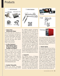
April 2024 - Marine News page: 43Products 1 2 VETUS Maxwell In-Mar Solutions 3 Furuno ABB 4 for workboat operators encompasses EH Group 1. Heavy Duty 5 three large-sized MFDs with wide, all- Windscreen Wiper glass displays: the 16” TZT16X, 22” Heavy-duty wiper has a thermal cut- TZT22X and 24” TZT24X. Powered out in
-
 )
April 2024 - Marine News page: 42
)
April 2024 - Marine News page: 42reau, moving from the operations named Vigor’s vice president of department to member services. fabrication. Webb Institute Promotes Austal USA Names Martin Parsons VP Webb Institute has promoted Mi- Austal USA has named Kristin chael Martin to the position of Lester Parsons as the company’s vice pres-
-
 )
April 2024 - Marine News page: 39
)
April 2024 - Marine News page: 39There are ? ve major paint catego- lenges in shipyards is managing small building is a multifaceted endeavor ries in new construction shipbuilding: parts, which are prone to surface rust that demands integrative systems before installation. Optimizing the planning, as well as adoption of new 1.
-
 )
April 2024 - Marine News page: 27
)
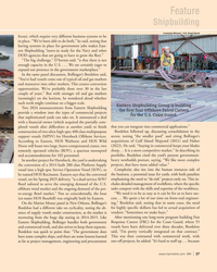
April 2024 - Marine News page: 27Feature Shipbuilding Loumania Stewart / U.S. Coast Guard focus), which require very different business systems to be in place. “We’ve been able to do both,” he said, noting that having systems in place for government jobs makes East- ern Shipbuilding “move-in ready for the Navy and other DOD agencies
-
 )
April 2024 - Marine News page: 23
)
April 2024 - Marine News page: 23the rule new projects might be set within historical vessel routes, con? icting with existing maritime uses and users. The USCG’s fairway proposal is based on BOEM’s exist- ing WEA projections (contained in the December Notice). The 18 proposed fairways, traf? c separation schemes and precautionary
-
 )
April 2024 - Marine News page: 22
)
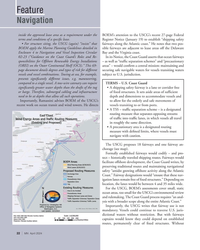
April 2024 - Marine News page: 22Feature Navigation inside the approved lease area as a requirement under the BOEM’s attention to the USCG’s recent 27-page Federal terms and conditions of a speci? c lease. Register Notice (January 19) to establish “shipping safety • For structure siting, the USCG (again) “insists” that fairways along
-
 )
April 2024 - Marine News page: 16
)
April 2024 - Marine News page: 16OpEd Shipbuilding U.S. Commercial Shipbuilding and Repair Industry Ensures American Strength at Sea By Matthew Paxton, President, Shipbuilders Council of America As Senator Roger Wicker force, the U.S. is falling behind. China, Korea and Japan of Mississippi once said, “Growth in commercial ship-
-
 )
April 2024 - Marine News page: 12
)
April 2024 - Marine News page: 12Insights century technology in 2024.” That’s an area of focus. industry. We want to do that in a realistic way. These are We also want to make sure that we have workers on our great careers where a hardworking person can make a six- vessels who are ? t for duty. One of the things that we have ? gure
-
 )
February 2024 - Maritime Reporter and Engineering News page: 40
)
February 2024 - Maritime Reporter and Engineering News page: 40Images Seaspan Corporation/Foreship With plans to have a full-scale test engine running on am- age it'll be similar to LNG.” Looking at the engine makers and monia in early 2024, the company said it expects to hold its de- their progress, Brindley is diplomatic in saying that there is no livery timeline