Floating Offshore Wind: New Seascape, New Challenges
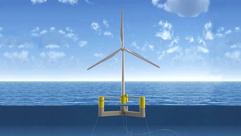
Offshore wind energy planners are giving close review to fixed-tower systems in order to extend lessons learned to floating wind towers, under development now. In the U.S., floating towers have been most closely associated with plans for new wind energy areas (WEA) in the Pacific, off of California and maybe Oregon and Washington. But important research is also taking place in Maine, at the University of Maine, because of deep ocean Atlantic areas there, and floating towers may also be used in the Gulf of Mexico.
As most readers likely know, floating wind energy turbines offer the chance to take advantage of rich wind areas in waters too deep for fixed turbine construction. Floating towers, though, present new and different and additional technical and maritime challenges. Once resolved, however, floating technology would make accessible WEAs with strong and constant wind energy.
This emerging industry and technology were the focus of the most recent annual Floating Wind Solutions (FWS) conference held in Houston, January 30 – February 1. The FWS conferences provide an opportunity for project leaders to focus on the industrialization and commercialization of floating wind energy. Interest is growing - 850 people, from over 400 different global companies, attended FWS '23; that’s up from 600 people at FWS '22 and 400 at FWS '21. Organizers expect over 1,000 at the 2024 event. The U.S. DOE maintains a link to the conference and provides a registration link on its website, although DOE does not have a formal role within the conference organization and presentations.
The 2023 conference started with a series of presentations headlined “Floating Wind: Transfer Learnings of Deepwater Development.” This category included a session on environmental and regulatory issues. Larry Wise, Senior Coastal Marine Engineer with W.F. Baird & Associates, based in Houston, presented a discussion on “Navigation Safety Considerations and Permitting for a Floating Wind Project in USA.” Wise has been part of the research team at the University of Maine Aqua Ventus project, also known now as the New England Aqua Ventus project because of additional partners and expanded project scope.
 (Image: University of Maine)
Wise first referenced the requirements set within a Navigation Safety Risk Assessment (NRSA) which identifies and evaluates a project’s hazards and risks to vessel navigation. BOEM requires an NSRA for offshore projects. The central document here is the USCG’s Navigation and Vessel Inspection Circular No. 01-19, “Guidance on the Coast Guard’s Roles and Responsibilities for Offshore Renewable Energy Installations.” Wise said the NSRA tells the Coast Guard what objects will be placed in the waterway. He added that various states may also require additional permits or approvals, particularly within a state’s three-mile offshore ocean boundary.
Traffic analysis is done using AIS – automatic identification systems – data. AIS tells what kind of ships are in a proposed WEA and the vessels’ locations.
The NSRA outlines the steps needed to avoid and minimize navigation conflicts. This is critical not just for safety but, Wise added, because it impacts the layout of the project within the WEA and the profitability of the project. Wise said that developing clear and unambiguous warning systems is a challenge within a floating wind tower project area. Avoidance measures – for fixed or floating projects – can include navigation lanes, setbacks and safe access for fishing vessels.
Wise listed other navigation impacts from wind towers including radar degradation, electromagnetic interference, noise and, of course, visual and line-of-sight problems because of new structures and construction equipment. He said that corridor widths between turbines are based on a number of considerations including power generation requirements, vessel navigation, commercial fishing, search and rescue, existing surface and sub-surface infrastructure, and seabed conditions. Lane width analyses are based on European experiences and documents. For reference, Wise cited the “White Paper on Offshore Wind Energy” written by the Netherlands’ Ministry of Infrastructure and the Environment and The Ministry of Economic Affairs in 2014.
Readers may recall that in February 2022 the National Academy of Sciences released a study sponsored by BOEM that documented how wind towers degrade maritime radar. Turbines clutter a radar’s display, resulting in an ambiguous and confusing picture for the operator, according to the NAS report.
Wise was asked about developments pertaining to radar-wind turbine impacts. He cited the NAS February 2022 report as the latest guidance and that the report includes a number of recommendations for testing, data collection and evaluation.
Mitigating radar impacts remains a high-level focus for a number of federal agencies, including the Departments of Defense and Energy as well as for NOAA and BOEM. The exact status of this work, however, at least since last February, isn’t clear. A BOEM spokesperson said that BOEM now uses the NAS report for environmental studies; specific questions about follow up, though, were referred to the Coast Guard.
DOE has a website for the “Wind Turbine-Radar Interference Mitigation Working Group.” The Department of Homeland Security, which includes the Coast Guard, is listed as a Working Group “observer,” not a direct participant.
A DOE web page explains that a Memorandum of Understanding, first signed in 2014, was updated this year - in 2023, but the link to the MOU posted on the website does not detail this recent work. Importantly, DOE’s goal – by 2025 – is to accomplish the following:
- Address wind turbine radar interference as an impact to critical radar missions;
- Ensure the long-term resilience of radar operations in the presence of wind turbines, and,
- Remove radar interference as an impediment to future wind energy development.
- Wise said that port activities need to be part of a wind energy project analyses. Port officials need to know where construction will occur and how a port’s operational issues may be impacted. Risk modeling estimates whether and how navigational risks will increase once a project is complete. Wise said that most models show only a slight increase in risks for ports from OSW fixed-structure projects (see figure 1).
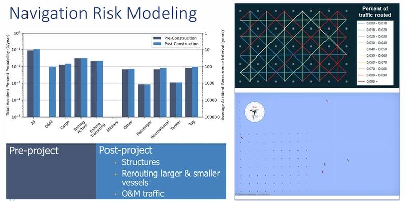 Figure 3, courtesy Larry Wise
After referencing fundamental issues within fixed-tower WEAs Wise turned to some of the unique challenges from the navigational footprint of floating towers. He said the work at the University of Maine Aqua Ventus project has been helpful in assessing and addressing floating tower impacts.
Wise gave particular attention to emergency response capabilities within project areas. Emergency response, of course, includes events in which people are in direct and immediate danger – man-overboard, for example, or taking-on-water or collisions – events demanding a no-wait response despite weather and ocean conditions. Other emergencies may not present immediate life-death outcomes but still demand immediate action – an oil spill, for example, or loss of power or a stranded, drifting vessel.
The point is that for first responders’ access and transit through an OSW area are critical parts of up-front planning (see figure 2, presenting 20 years of maritime emergency data off of New Jersey).
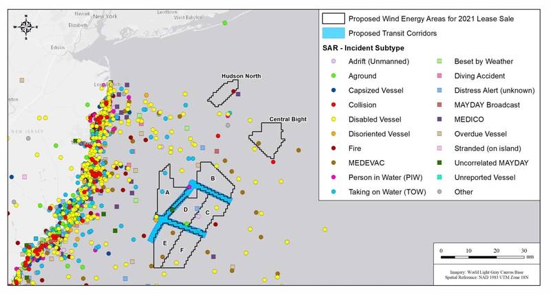 Figure 3, courtesy Larry Wise
Wise said floating towers present a much larger footprint compared to fixed towers. Floating towers will have anchor lines in many directions. But floating turbines will still move to some degree, even though that movement is limited. Floating towers will be linked by an inner array of cables between the turbines (see figure 3). Hence the concerns about access and navigation for emergency crews.
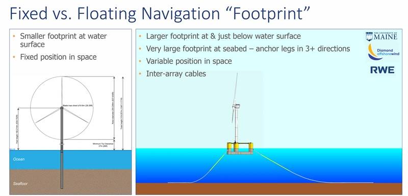 Figure 3, courtesy Larry Wise
In response to questions, Wise said he does not anticipate much difference in impacts to search and rescue operations with fixed versus floating wind projects. He said anchor chains will need to be avoided – generally affecting surface vessels within <30m of a structure. Lane widths, though, will likely be the same. He said that “risks in terms of search and rescue are complex and very much depend on experience from real world operations, not computer models.”
One open question is how all of this linked equipment should best be marked? Finding the right answers, Wise said, is part of the work going on with Aqua Ventus. If everything gets marked, Wise said that raises concerns about too much clutter, that mariners may turn off radar and other equipment because signals are overwhelming.
Wise said this is particularly important for commercial fishing because fishers are more likely to work within WEAs not just transit through. Wise referenced work with lobster fisherman in Maine, seeking their advice about keeping transit corridors safe but without overloading warning devices or systems, inadvertently creating a deluge of information for humans and machines that just might be ignored after a while.
Wise said the lobster fishers preferred a less-is-more approach: don’t mark each individual anchor, for example. These issues also extend to the dynamic export cables which deliver power from the turbines to equipment on shore. Wise said “sector lighting” approaches are under review, which he said could include placing a red light over the dynamic cables.
Again, though, he repeated the same concern: as more and more lights are set in more and more places the seascape could get more confusing, not less. He referenced added concern about recreational mariners who don’t have the same level of training and experience as commercial mariners.
And he added another note of caution. The references within his presentation were for pilot projects. He said that once these projects “move to scale, to a full array of turbines, you can see the challenge” from anchors going in multiple directions. Another issue is how or whether all of this equipment might be included – or should be included – in nautical charts. Wise again referenced concern that mariners might start to turn off charting systems because of clutter and then miss critical safety information.
 “Risks in terms of search and rescue are complex and very much depend on experience from real world operations, not computer models.” - Larry Wise, Senior Coastal Marine Engineer, W.F. Baird & Associates (Photo: W.F. Baird & Associates)
Going forward, Wise said that efforts to find the best answers to these questions about how the seascape looks within floating wind towers remains a focus for New England Aqua Ventus researchers. Another goal is to develop systems consistent with international standards so that all captains are familiar with warning signs and messages when vessels enter U.S. waters.
The American Waterways Operators was asked about how they are prioritizing concerns associated with floating wind towers. A spokesman noted that, indeed, these issues are being tracked but that floating towers are likely still quite a few years away from construction. And AWO members have a rather straightforward position: avoid transiting among floating turbines. AWO’s primary focus is that regulatory authorities establish fairways that are wide enough to avoid any turbine-cable risks. The group is confident that these wide passageways will be set. Another concern, although admittedly more remote, is that a turbine breaks free and becomes a hazard in a fairway. AWO is following developments on both the West Coast and the Gulf of Maine.
Read Floating Offshore Wind: New Seascape, New Challenges in Pdf, Flash or Html5 edition of April 2023 Marine News
Other stories from April 2023 issue
Content
- Interview: Jennifer Carpenter, AWO page: 08
- Floating Offshore Wind: New Seascape, New Challenges page: 20
- Ammonia-powered Tug Conversion Underway page: 26
- 2023 US Shipbuilding Report page: 30
- Fuel Savings Are Just a ‘Nudge’ Away page: 36