
Page 29: of Marine Technology Magazine (Nov/Dec 2005)
Seafloor Engineering
Read this page in Pdf, Flash or Html5 edition of Nov/Dec 2005 Marine Technology Magazine
 28
28
 30
30
www.seadiscovery.com Marine Technology Reporter 29
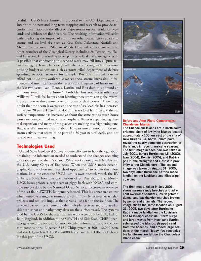
Before and After Photo Comparisons:
Chandeleur Islands
The Chandeleur Islands are a north-south oriented chain of low-lying islands located approximately 100 km east of the city of
New Orleans, La. Above, photo pairs reveal the nearly complete destruction of the islands in recent hurricane seasons.
The first image in each pair was taken in
July 2001, before Hurricanes Lili (2002),
Ivan (2004), Dennis (2005), and Katrina (2005, the strongest and closest in prox- imity to the Chandeleurs). The second image was taken on August 31, 2005, two days after Hurricane Katrina made landfall on the Louisiana and Mississippi coastline.
The first image, taken in July 2001, shows narrow sandy beaches and adja- cent overwash sandflats, low vegetated dunes, and backbarrier marshes broken by ponds and channels. The second image shows the same location on August 31, 2005, two days after Hurricane
Katrina made landfall on the Louisiana and Mississippi coastline. Storm surge and large waves from Hurricane Katrina submerged the islands, stripped sand from the beaches, and eroded large sec- tions of the marsh. Today, few recogniza- ble landforms are left on the Chandeleur
Island chain. cessful. USGS has submitted a proposal to the U.S. Department of
Interior to do near and long term mapping and research to provide sci- entific information on the affect of major storms on barrier islands, wet- lands and offshore sea floor features. The resulting information will assist with predicting the impact of storms on other coastal cities at risk to storms and sea-level rise such as New York, Galveston, Norfolk and
Miami, for instance. USGS in Woods Hole will collaborate with all other branches of the Geological Survey including St. Petersburg, Fla., and Lafayette, La., as well as other partner federal and state agencies. It is possible that conducting this type of work may fall into a "pure sci- ence" category. It may be a tough sell when competing with other more pressing budget allocations such as storm relief, department of defense spending, or social security, for example. But one must ask: can we afford not to do this work while we see these storms increasing in fre- quency and intensity? Given the severity and frequency of hurricanes in the last two years; Ivan, Dennis, Katrina and Rita does this portend an ominous trend for the future? "Probably, but not necessarily" says
Williams, " I will feel better about blaming these storms on global warm- ing after two or three more years of storms of their power." There is no doubt that the ocean is warmer and the rate of sea level rise has increased in the past 20 years. There is no doubt that sea level has risen and the sea surface temperature has increased at about the same rate as green house gasses are being emitted into the atmosphere. Water is experiencing ther- mal expansion and many of the glaciers are melting at a frightening rate.
But, says Williams we are also about 10 years into a period of increased storm activity that seems to be part of a 30-year natural cycle, and not related to climate warming.
Technologies Used
United State Geological Survey is quite efficient in how they go about obtaining the information needed to understand the changes occurring to various parts of the US coast. USGS works closely with NOAA and the U.S. Army Corps of Engineers. When the USGS needs oceano- graphic data, it often uses "vessels of opportunity" to obtain this infor- mation. In some cases the USGS uses its own research vessel, the RV
Gilbert, a 50-ft. boat that operates out of St. Petersburg, Fla.. Mostly,
USGS leases private survey boats or piggy back with NOAA and com- bine surveys done by the National Ocean Service. To create an overview of the sea floor, SWATH Bathymetry is used. This is a sonar transmitter which employs a single transmit array and multiple receiver arrays that projects and acoustic impulse that spreads like a fan to the sea floor. The reflected backscatter is sensed by the multiple receivers and displayed as side scan sonar and bathymetry data on the surface vessel. The systems used by the USGS for the after Katrina work were built by SEA, Ltd. of
Bath, England. In addition to the SWATH and Side Scan, CHIRP tech- nology is used to provide even more detailed information about the bot- tom compositions. Edgetech 512 I Chirp system at 500 - 12,000 hertz and the Edgetech 424 4000 - 24000 hertz are the CHIRPS of choice for this part of the USGS.
MTR#3 (17-32).qxd 11/14/2005 1:02 PM Page 29