Page 34: of Marine Technology Magazine (Jan/Feb 2007)
Seafloor Engineering
Read this page in Pdf, Flash or Html5 edition of Jan/Feb 2007 Marine Technology Magazine
 33
33
 35
35
Lou Tapscott, founder of Lighthouse R & D
Enterprises, has for four decades been mystified by the ocean. From diver to CEO, Tapscott has been involved with and intrigued by the mysteries of the sea. His thirst for knowledge has forged a quest to better understand current direction, eddies and earthquakes and the poten- tial impact of such ocean phenomena.
Lighthouse's flagship project is L.O.R.I. (Lighthouse
Oceans Research Initiative), which has its primary instal- lation off the coast of Oman. Through his earlier work in the Gulf of Mexico with one of Deep Star's projects, Met
Ocean, Tapscott became aware of the importance of loop currents in the Gulf of Mexico. With a vision of the potential impact globally of such patterns in deeper water,
Tapscott continued research in the field, and the Gulf of
Oman is one area that revealed a major loop current. With the interest and support of Oman's Ministry of Fisheries and Agriculture, in 2005 Lighthouse completed Phases I and II of the L.O.R.I. program in Oman
As a result of its position at the northern margin of the
Arabian Sea, the Gulf of Oman is a dynamic marine envi- ronment driven by the seasonal extremes of regional mon- soon events. Aside from environmental perturbations, the
Arabian Gulf is subject to real and potential pollution from the heavy traffic of large oil tankers entering and leaving the Arabian Gulf (Figure 1). Ballast water dis- charges, spills, and other effluents associated with such traffic are a continuing concern of Oman, whose pristine
Batinah coast is under development as a national resource for underutilized fisheries and an emerging recreational industry exploiting sport fishing, diving, and other tourist attractions. The Sultanate of Oman has a vital interest in preserving and protecting the coast. A recent deployment of oceanographic sensors is providing essential data neces- sary for monitoring existing conditions as well as provid- ing the basis for prediction of environmental impacts in the event of an accidental release of substances, which might threaten the coastal habitat.
The global oceanographic community is mobilizing and planning instrumented seabed arrays to monitor ocean parameters through cabled instrument strings reporting to a coastal station where data are fed to researchers. Several such links are in place in Canada, the Pacific (Hawaii),
Japan, the east coast of the U.S. and elsewhere. The
European community plans for extensive observatories under the ESONET program where more than 11 coun- tries will share marine data.
In the past year, the Sultanate of Oman's Ministry of
Agriculture and Fisheries has fielded an array of instru- ments to record current speed and direction, temperature, salinity, oxygen, and turbidity (Figure 2), leading the way to a Middle-Eastern data collection system in a vital region not yet studied in detail. The Sultanate of Oman's
Marine Science and Fisheries Center has emerged as the leader in oceanographic studies of the northern Arabian
Sea through its four offshore sites, which record on an hourly basis. Data are collected onshore and forwarded to the Oman Marine Science and Fisheries Center 34 MTR January 2007
First Mid-East Cabled Seabed
Observatory
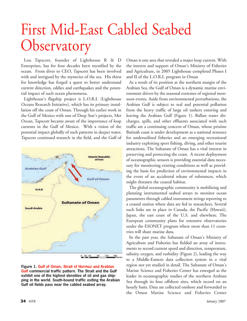
Figure 1. Gulf of Oman, Strait of Hormuz and Arabian
Gulf commercial traffic pattern. The Strait and the Gulf exhibit one of the highest densities of oil and gas ship- ping in the world. South-bound traffic exiting the Arabian
Gulf oil fields pass near the cabled seabed array.
MTR#1 (33-48).qxd 1/11/2007 4:12 PM Page 34