Page 25: of Marine Technology Magazine (Nov/Dec 2010)
Fresh Water Monitoring and Sensors(lakes, rivers, reservoirs)
Read this page in Pdf, Flash or Html5 edition of Nov/Dec 2010 Marine Technology Magazine
 24
24
 26
26
www.seadiscovery.com Marine Technology Reporter 25
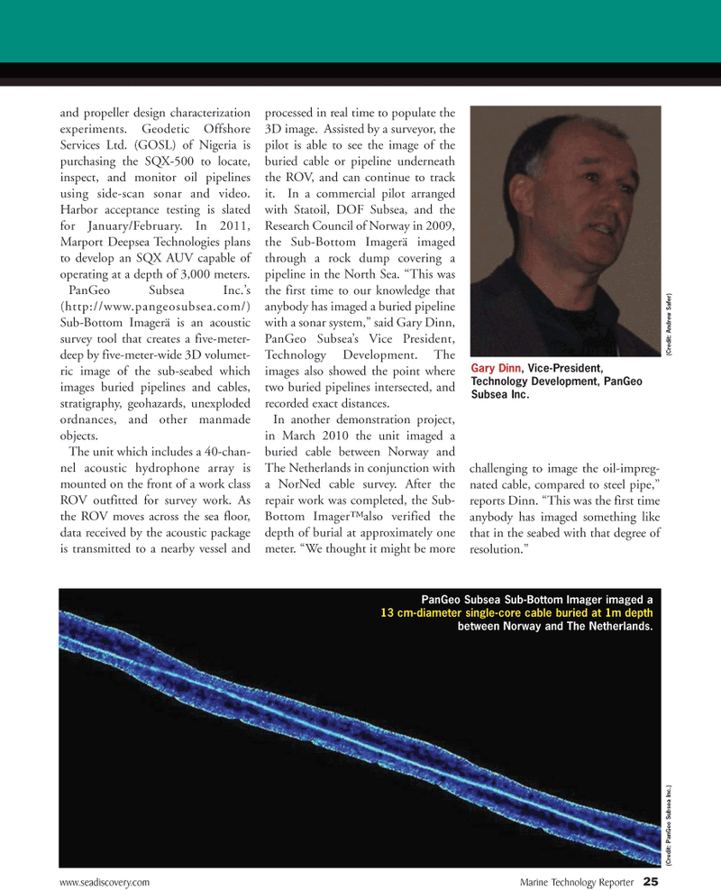
PanGeo Subsea Sub-Bottom Imager imaged a 13 cm-diameter single-core cable buried at 1m depth between Norway and The Netherlands. and propeller design characterization experiments. Geodetic Offshore
Services Ltd. (GOSL) of Nigeria is purchasing the SQX-500 to locate, inspect, and monitor oil pipelines using side-scan sonar and video.
Harbor acceptance testing is slated for January/February. In 2011,
Marport Deepsea Technologies plans to develop an SQX AUV capable of operating at a depth of 3,000 meters.
PanGeo Subsea Inc.’s (http://www.pangeosubsea.com/)
Sub-Bottom Imagerä is an acoustic survey tool that creates a five-meter- deep by five-meter-wide 3D volumet- ric image of the sub-seabed which images buried pipelines and cables, stratigraphy, geohazards, unexploded ordnances, and other manmade objects.
The unit which includes a 40-chan- nel acoustic hydrophone array is mounted on the front of a work class
ROV outfitted for survey work. As the ROV moves across the sea floor, data received by the acoustic package is transmitted to a nearby vessel and processed in real time to populate the 3D image. Assisted by a surveyor, the pilot is able to see the image of the buried cable or pipeline underneath the ROV, and can continue to track it. In a commercial pilot arranged with Statoil, DOF Subsea, and the
Research Council of Norway in 2009, the Sub-Bottom Imagerä imaged through a rock dump covering a pipeline in the North Sea. “This was the first time to our knowledge that anybody has imaged a buried pipeline with a sonar system,” said Gary Dinn,
PanGeo Subsea’s Vice President,
Technology Development. The images also showed the point where two buried pipelines intersected, and recorded exact distances.
In another demonstration project, in March 2010 the unit imaged a buried cable between Norway and
The Netherlands in conjunction with a NorNed cable survey. After the repair work was completed, the Sub-
Bottom Imager™ also verified the depth of burial at approximately one meter. “We thought it might be more challenging to image the oil-impreg- nated cable, compared to steel pipe,” reports Dinn. “This was the first time anybody has imaged something like that in the seabed with that degree of resolution.” (Cr edit: PanGeo Subsea Inc.)
Gary Dinn, Vice-President,
Technology Development, PanGeo
Subsea Inc. (Cr edit: Andr ew Safer)