Page 28: of Marine Technology Magazine (Sep/Oct 2011)
Ocean Observation
Read this page in Pdf, Flash or Html5 edition of Sep/Oct 2011 Marine Technology Magazine
 27
27
 29
29
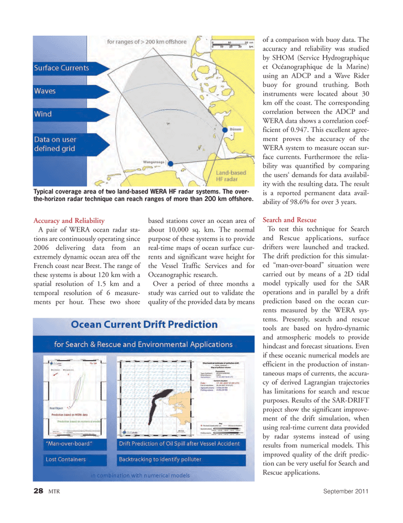
28MTRSeptember2011 Accuracy and Reliability A pair of WERA ocean radar sta- tions are continuously operating since2006 delivering data from an extremely dynamic ocean area off the French coast near Brest. The range of these systems is about 120 km with aspatial resolution of 1.5 km and a temporal resolution of 6 measure- ments per hour. These two shore based stations cover an ocean area of about 10,000 sq. km. The normal purpose of these systems is to provide real-time maps of ocean surface cur- rents and significant wave height for the Vessel Traffic Services and for Oceanographic research. Over a period of three months a study was carried out to validate the quality of the provided data by means of a comparison with buoy data. The accuracy and reliability was studied by SHOM (Service Hydrographique et Océanographique de la Marine) using an ADCP and a Wave Rider buoy for ground truthing. Both instruments were located about 30 km off the coast. The corresponding correlation between the ADCP and WERA data shows a correlation coef- ficient of 0.947. This excellent agree- ment proves the accuracy of the WERA system to measure ocean sur- face currents. Furthermore the relia- bility was quantified by comparing the users? demands for data availabil- ity with the resulting data. The result is a reported permanent data avail- ability of 98.6% for over 3 years. Search and Rescue To test this technique for Search and Rescue applications, surface drifters were launched and tracked. The drift prediction for this simulat- ed ?man-over-board? situation were carried out by means of a 2D tidal model typically used for the SARoperations and in parallel by a drift prediction based on the ocean cur- rents measured by the WERA sys- tems. Presently, search and rescue tools are based on hydro-dynamic and atmospheric models to provide hindcast and forecast situations. Even if these oceanic numerical models are efficient in the production of instan- taneous maps of currents, the accura- cy of derived Lagrangian trajectories has limitations for search and rescue purposes. Results of the SAR-DRIFT project show the significant improve- ment of the drift simulation, whenusing real-time current data provided by radar systems instead of using results from numerical models. This improved quality of the drift predic- tion can be very useful for Search and Rescue applications. Typical coverage area of two land-based WERA HF radar systems. The over- the-horizon radar technique can reach ranges of more than 200 km offshore. MTR#7 (18-33):MTR Layouts 8/29/2011 9:58 AM Page 28