
Page 22: of Marine Technology Magazine (Oct/Nov 2011)
Ocean Engineering & Design
Read this page in Pdf, Flash or Html5 edition of Oct/Nov 2011 Marine Technology Magazine
 21
21
 23
23
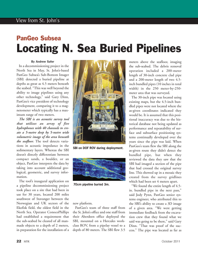
By Andrew Safer In a decommissioning project in the North Sea in May, St. John?s-based PanGeo Subsea?s Sub-Bottom Imager (SBI) detected a buried pipeline atdepths as great as 4.5 meters beneath the seabed. ?This was well beyond the ability to image pipelines using anyother technology,? said Gary Dinn, PanGeo?s vice president of technology development, comparing it to a mag- netometer which typically has a max-imum range of two meters. The SBI is an acoustic survey tool that utilizes an array of five hydrophones with 40 channels to cre- ate a 5-metre deep by 5-metre wide volumetric image of the area beneath the seafloor. The tool detects varia- tions in acoustic impedance in thesedimentary layers. Whereas the SBI doesn?t directly differentiate between compact sands, a boulder, or an object, PanGeo interprets the data by taking into account additional geo-logical, geometric, and survey infor- mation. The tool?s inaugural application on a pipeline decommissioning project took place on a site that had been inuse for 30 years, located 200 miles southwest of Stavanger between the Norwegian and UK sectors of the Ekofisk field, the oldest field in the North Sea. Operator ConocoPhillips had established a requirement that the sub-seabed be cleared of all man- made objects to a depth of 2 meters,in preparation for the installation of a new platform. PanGeo?s team of three staff from the St. John?s office and one staff from their Aberdeen office deployed the SBI, mounted on a Hercules work- class ROV, from a pipelay vessel to a depth of 80 meters. The SBI flew 3.5 meters above the seafloor, imaging the sub-seabed. The debris removal operation included a 200-meterlength of 30-inch concrete clad pipe and a 200-meter length of two 4.5-inch bundled pipes (10 inches in totalwidth) in the 250 meter-by-250- meter area that was surveyed. The 30-inch pipe was located usingexisting maps, but the 4.5-inch bun-dled pipes were not located where the as-given coordinates indicated they would be. It is assumed that this posi- tional inaccuracy was due to the his-torical database not being updated asperformance and repeatability of sur- face and subsurface positioning sys- tems continually developed over the years since the pipe was laid. When PanGeo?s team flew the SBI along the as-given route they didn?t detect the bundled pipe, but when theyreviewed the data they saw that the SBI had imaged a section of the pipethat had crossed the original survey line. This showed up in a mosaic they created from the survey gridlines which had been set 4 meters apart. ?We found the entire length of 4.5- in. bundled pipe in the next pass,?said Jody Pynn, PanGeo senior sys- tems engineer, who attributed this to the SBI?s ability to create a 3D image of a given area. ?We were getting immediate feedback from the excava- tion crew that they found what we said was going to be there,? said Gary Dinn. ?That was proof of the suc- cess.? The pipe was located as far as 22MTROctober2011 View from St. John?s PanGeo SubseaLocating N. Sea Buried Pipelines SBI on DOF ROV during deployment.70cm pipeline buried 3m.MTR#8 (18-33):MTR Layouts 10/10/2011 2:01 PM Page 22