Page 49: of Marine Technology Magazine (Oct/Nov 2011)
Ocean Engineering & Design
Read this page in Pdf, Flash or Html5 edition of Oct/Nov 2011 Marine Technology Magazine
 48
48
 50
50
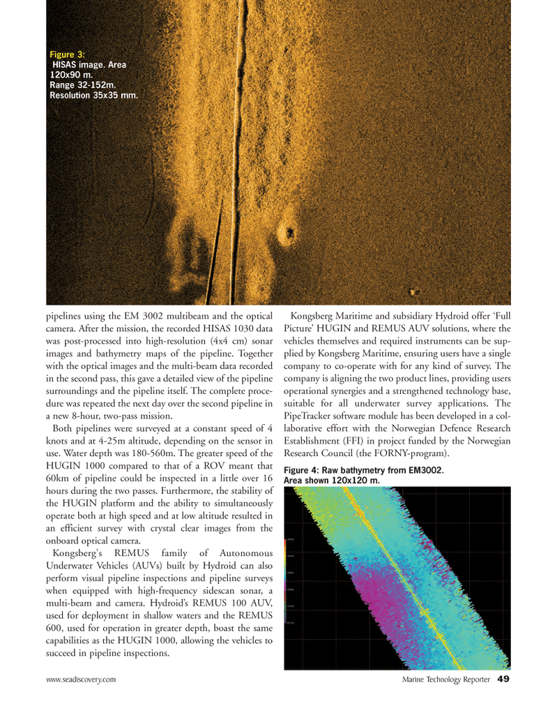
www.seadiscovery.com Marine Technology Reporter 49pipelines using the EM 3002 multibeam and the opticalcamera. After the mission, the recorded HISAS 1030 data was post-processed into high-resolution (4x4 cm) sonar images and bathymetry maps of the pipeline. Together with the optical images and the multi-beam data recorded in the second pass, this gave a detailed view of the pipeline surroundings and the pipeline itself. The complete proce- dure was repeated the next day over the second pipeline in a new 8-hour, two-pass mission. Both pipelines were surveyed at a constant speed of 4 knots and at 4-25m altitude, depending on the sensor inuse. Water depth was 180-560m. The greater speed of the HUGIN 1000 compared to that of a ROV meant that 60km of pipeline could be inspected in a little over 16 hours during the two passes. Furthermore, the stability of the HUGIN platform and the ability to simultaneouslyoperate both at high speed and at low altitude resulted in an efficient survey with crystal clear images from the onboard optical camera. Kongsberg's REMUS family of Autonomous Underwater Vehicles (AUVs) built by Hydroid can also perform visual pipeline inspections and pipeline surveys when equipped with high-frequency sidescan sonar, a multi-beam and camera. Hydroid?s REMUS 100 AUV, used for deployment in shallow waters and the REMUS 600, used for operation in greater depth, boast the same capabilities as the HUGIN 1000, allowing the vehicles to succeed in pipeline inspections. Kongsberg Maritime and subsidiary Hydroid offer ?Full Picture? HUGIN and REMUS AUV solutions, where the vehicles themselves and required instruments can be sup- plied by Kongsberg Maritime, ensuring users have a single company to co-operate with for any kind of survey. The company is aligning the two product lines, providing users operational synergies and a strengthened technology base, suitable for all underwater survey applications. The PipeTracker software module has been developed in a col- laborative effort with the Norwegian Defence Research Establishment (FFI) in project funded by the Norwegian Research Council (the FORNY-program). Figure 3: HISAS image. Area 120x90 m. Range 32-152m.Resolution 35x35 mm.Figure 4: Raw bathymetry from EM3002. Area shown 120x120 m. MTR#8 (34-49):MTR Layouts 10/10/2011 11:40 AM Page 49