
Page 40: of Marine Technology Magazine (Apr/May 2013)
Offshore Energy Report
Read this page in Pdf, Flash or Html5 edition of Apr/May 2013 Marine Technology Magazine
 39
39
 41
41
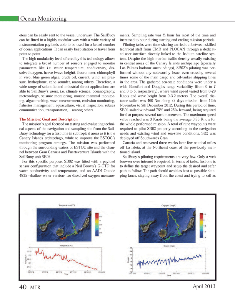
eters can be easily sent to the vessel underway. The SailBuoy can be Þ tted in a highly modular way with a wide variety of instrumentation payloads able to be used for a broad number of ocean applications. It can easily keep station or travel from point to point.The high modularity level offered by this technology allows to integrate a broad number of sensors engaged to monitor parameters like i.e. water temperature, conductivity, dis- solved oxygen, heave (wave height), ß uorometer, chlorophyll in vivo, blue green algae, crude oil, current, wind, air pres- sure. hydrophone, echo sounder, among others. Therefore, a wide range of scientiÞ c and industrial direct applications are able to SailBuoyÕs users, i.e. climate science, oceanography, meteorology, seismic monitoring, marine mammal monitor- ing, algae tracking, wave measurement, emission monitoring, Þ sheries management, aquaculture, visual inspection, subsea communication, transportation,... among others.The Mission: Goal and DescriptionThe missionÕs goal focused on testing and evaluating techni- cal aspects of the navigation and sampling site from the Sail- Buoy technology for a Þ rst time in subtropical areas as it is the Canary Islands archipelago, while to improve the ESTOCÕs monitoring program strategy. The mission was performed through the surrounding waters of ESTOC site and the chan- nel between Gran Canaria and Fuerteventura Islands with the SailBuoy unit SB02. For this speciÞ c purpose, SB02 was Þ tted with a payload sensor conÞ guration that include a Neil BrownÕs G-CTD for water conductivity and temperature, and an AADI Optode 4835 -shallow water version- for dissolved oxygen measure- ments. Sampling rate was ½ hour for most of the time and increased to hour during starting and ending mission periods.Piloting tasks were time-sharing carried out between skilled technical staff from CMR and PLOCAN through a dedicat- ed user interface directly linked to the Iridium satellite sys- tem. Despite the high marine trafÞ c density usually existing in central areas of the Canary Islands archipelago (specially Las Palmas harbour surroundings), SB02Õs piloting was per- formed without any noteworthy issue, even crossing several times some of the main cargo and oil-tanker shipping lines in the area. The gathered sea-state conditions were under a wide Beaufort and Douglas range variability (from 0 to 7 and 0 to 5, respectively), where wind speed varied from 0-29 Knots and wave height from 0-3.2 meters. The overall dis- tance sailed was 460 Nm along 22 days mission, from 13th November to 5th December 2012. During this period of time, SB02 sailed windward 75% and 25% leeward, being required for that purpose several tack maneuvers. The maximum speed value reached was 3 Knots being the average 0.85 Knots for the whole performed mission. A total of nine waypoints were required to pilot SB02 properly according to the navigation needs and existing wind and sea-state conditions. SB2 was deployed off Southwards Gran Canaria and recovered three weeks later few nautical miles off La Isleta, at the Northeast coast of the previously men- tioned island.SailBuoyÕs piloting requirements are very few. Only a web browser over internet is required. In terms of tasks, Þ rst one is to deÞ ne the target waypoint and setup the desired and safer path to follow. The path should avoid as best as possible ship- ping lanes, staying away from the coast and trying to sail as Ocean Monitoring April 201340 MTRMTR #3 (34-49).indd 40MTR #3 (34-49).indd 404/4/2013 9:23:52 AM4/4/2013 9:23:52 AM