
Page 40: of Marine Technology Magazine (Jul/Aug 2014)
MTR100
Read this page in Pdf, Flash or Html5 edition of Jul/Aug 2014 Marine Technology Magazine
 39
39
 41
41
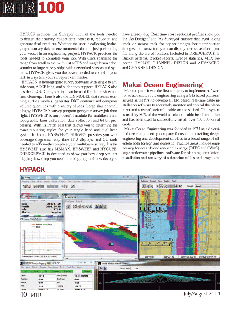
HYPACK provides the Surveyor with all the tools needed to design their survey, collect data, process it, reduce it, and generate Þ nal products. Whether the user is collecting hydro- graphic survey data or environmental data, or just positioning your vessel in an engineering project, HYPACK provides the tools needed to complete your job. With users spanning the range from small vessel with just a GPS and single beam echo- sounder to large survey ships with networked sensors and sys- tems, HYPACK gives you the power needed to complete your task in a system your surveyors can master. HYPACK, a hydrographic survey software with single beam, side scan, ADCP Mag, and subbottom support. HYPACK also has the CLOUD program that can be used for data review and Þ nal clean-up. There is also the TIN MODEL that creates stun- ning surface models, generates DXF contours and computes volume quantities with a variety of jobs. Large ship or small dinghy, HYPACKÕs survey program gets your survey job done right. HYSWEEP is our powerful module for multibeam and topographic laser calibration, data collection and 64 bit pro-cessing. With its Patch Test that allows you to determine the exact mounting angles for your single head and dual head system in hours. HYSWEEPÕs SURVEY provides you with coverage diagrams, relay time TPU displays, and QC tools needed to efÞ ciently complete your multibeam survey. Lastly, HYSWEEP also has MBMAX, HYSWEEP and HYCUBE. DREDGEPACK is designed to show you how deep you are digging, how deep you need to be digging, and how deep you have already dug. Real time cross sectional proÞ les show you the ÔAs DredgedÕ and ÔAs SurveyedÕ surface displayed Ôalong trackÕ or Ôacross trackÕ for hopper dredges. For cutter suction dredges and excavators you can display a cross sectional pro- Þ le along the arc of rotation. Included in DREDGEPACK is, Bucket patterns, Bucket reports, Dredge statistics, MTX Re- porter, HYPLOT, CHANNEL DESIGN and ADVANCED, and CHANNEL DESIGN.Makai Ocean EngineeringMakai reports it was the Þ rst company to implement software for subsea cable route engineering using a GIS based platform, as well as the Þ rst to develop a FEM based, real-time cable in- stallation software to accurately monitor and control the place- ment and tension/slack of a cable on the seabed. This system is used by 80% of the worldÕs Telecom cable installation ß eet and has been used to successfully install over 400,000 km of cable.Makai Ocean Engineering was founded in 1973 as a diversi- Þ ed ocean engineering company focused on providing design engineering and development services to a broad range of cli- entele both foreign and domestic. Practice areas include engi-neering for ocean based renewable energy (OTEC and SWAC), large underwater pipelines, software for planning, simulation, installation and recovery of submarine cables and arrays, and MTR MTR 100 100HYPACK July/August 2014 40 MTRMTR #6 (34-49).indd 40MTR #6 (34-49).indd 407/30/2014 9:30:42 AM7/30/2014 9:30:42 AM