
Page 34: of Marine Technology Magazine (Oct/Nov 2014)
Subsea Defense
Read this page in Pdf, Flash or Html5 edition of Oct/Nov 2014 Marine Technology Magazine
 33
33
 35
35
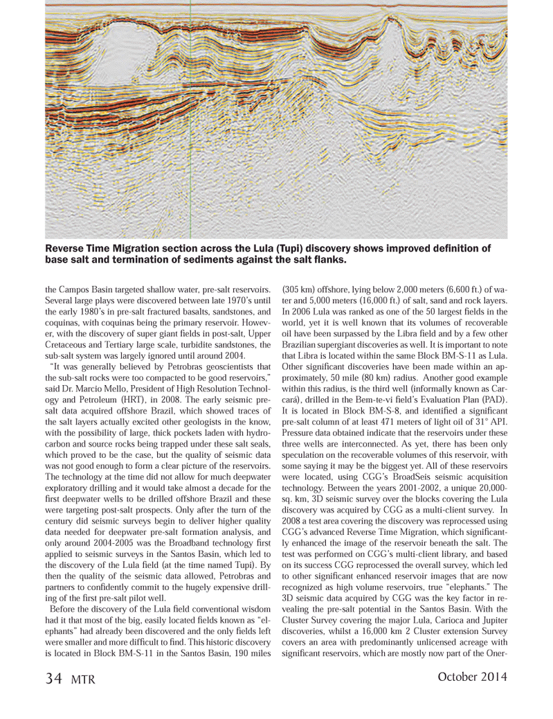
the Campos Basin targeted shallow water, pre-salt reservoirs. Several large plays were discovered between late 1970?s until the early 1980?s in pre-salt fractured basalts, sandstones, and coquinas, with coquinas being the primary reservoir. Howev- er, with the discovery of super giant elds in post-salt, Upper Cretaceous and Tertiary large scale, turbidite sandstones, the sub-salt system was largely ignored until around 2004. ?It was generally believed by Petrobras geoscientists that the sub-salt rocks were too compacted to be good reservoirs,? said Dr. Marcio Mello, President of High Resolution Technol- ogy and Petroleum (HRT), in 2008. The early seismic pre- salt data acquired offshore Brazil, which showed traces of the salt layers actually excited other geologists in the know, with the possibility of large, thick pockets laden with hydro- carbon and source rocks being trapped under these salt seals, which proved to be the case, but the quality of seismic data was not good enough to form a clear picture of the reservoirs. The technology at the time did not allow for much deepwater exploratory drilling and it would take almost a decade for the rst deepwater wells to be drilled offshore Brazil and these were targeting post-salt prospects. Only after the turn of the century did seismic surveys begin to deliver higher quality data needed for deepwater pre-salt formation analysis, and only around 2004-2005 was the Broadband technology rst applied to seismic surveys in the Santos Basin, which led to the discovery of the Lula eld (at the time named Tupi). By then the quality of the seismic data allowed, Petrobras and partners to con dently commit to the hugely expensive drill- ing of the rst pre-salt pilot well. Before the discovery of the Lula eld conventional wisdom had it that most of the big, easily located elds known as ?el- ephants? had already been discovered and the only elds left were smaller and more dif cult to nd. This historic discovery is located in Block BM-S-11 in the Santos Basin, 190 miles (305 km) offshore, lying below 2,000 meters (6,600 ft.) of wa- ter and 5,000 meters (16,000 ft.) of salt, sand and rock layers. In 2006 Lula was ranked as one of the 50 largest elds in the world, yet it is well known that its volumes of recoverable oil have been surpassed by the Libra eld and by a few other Brazilian supergiant discoveries as well. It is important to note that Libra is located within the same Block BM-S-11 as Lula. Other signi cant discoveries have been made within an ap- proximately, 50 mile (80 km) radius. Another good example within this radius, is the third well (informally known as Car- cará), drilled in the Bem-te-vi eld?s Evaluation Plan (PAD). It is located in Block BM-S-8, and identi ed a signi cant pre-salt column of at least 471 meters of light oil of 31° API. Pressure data obtained indicate that the reservoirs under these three wells are interconnected. As yet, there has been only speculation on the recoverable volumes of this reservoir, with some saying it may be the biggest yet. All of these reservoirs were located, using CGG?s BroadSeis seismic acquisition technology. Between the years 2001-2002, a unique 20,000- sq. km, 3D seismic survey over the blocks covering the Lula discovery was acquired by CGG as a multi-client survey. In 2008 a test area covering the discovery was reprocessed using CGG?s advanced Reverse Time Migration, which signi cant-ly enhanced the image of the reservoir beneath the salt. The test was performed on CGG?s multi-client library, and based on its success CGG reprocessed the overall survey, which led to other signi cant enhanced reservoir images that are now recognized as high volume reservoirs, true ?elephants.? The 3D seismic data acquired by CGG was the key factor in re- vealing the pre-salt potential in the Santos Basin. With the Cluster Survey covering the major Lula, Carioca and Jupiter discoveries, whilst a 16,000 km 2 Cluster extension Survey covers an area with predominantly unlicensed acreage with signi cant reservoirs, which are mostly now part of the Oner- Reverse Time Migration section across the Lula (Tupi) discovery shows improved de Þ nition of base salt and termination of sediments against the salt ß anks. October 201434 MTRMTR #8 (34-49).indd 34MTR #8 (34-49).indd 3410/10/2014 11:10:33 AM10/10/2014 11:10:33 AM