Page 38: of Marine Technology Magazine (Apr/May 2015)
Offshore Energy Annual
Read this page in Pdf, Flash or Html5 edition of Apr/May 2015 Marine Technology Magazine
 37
37
 39
39
Survey 3D Image 3D Image
Fusion 3D Image FusionFusion for Ultra High Resolution Seabed Surveys
By Karl Kenny, President and CEO, Kraken Sonar Inc.
ea? oor mapping is one of the oldest professions known concerted efforts have been made to compile sonar bathymet- to humankind. Mariners have been measuring the depths ric data in the public and classi? ed domains to produce high-
Sunder their vessels for thousands of years. The science er-resolution 3D digital terrain models of the sea? oor Given of measuring and charting the depths to determine the topog- that seabed surveys are often conducted in areas for which raphy of the sea? oor is known as bathymetry. Bathymetry is little a-priori information is available, the real-time genera- gathered from a variety of sources, including satellites, air- tion of 3D seabed maps will signi? cantly improve our ability craft, surface ships, submersibles and underwater platforms. to explore and understand the sea? oor environment.
Bathymetric data are used to generate navigational charts, 3D While conventional sonars are commonly used for sea? oor models, sea? oor pro? les and other fusion images. Today, gov- imaging and bathymetry, they suffer from some basic limita- ernments, navies, telecom companies, offshore energy corpo- tions. Firstly, the imaging resolution, or the system’s ability rations and scienti? c institutions map the sea? oor for many to distinguish closely spaced objects, is not constant but de- applications. Knowledge about the sea? oor is imperative to grades with range. In Synthetic Aperture Sonar (SAS), these better understand our oceans. limitations are overcome by using the sonar platform’s trajec-
Our perception of the ocean ? oor has expanded through the tory. The forward motion of the sonar is used to synthesise an use of 3D geospatial applications. However, most 3D bathym- array that is much longer than its physical length by combin- etry maps that historically represent continuous global sea- ing multiple pings in software rather than adding more hard- ? oor coverage are artist renditions. It wasn’t until recently that ware as a way to gain higher resolutions.
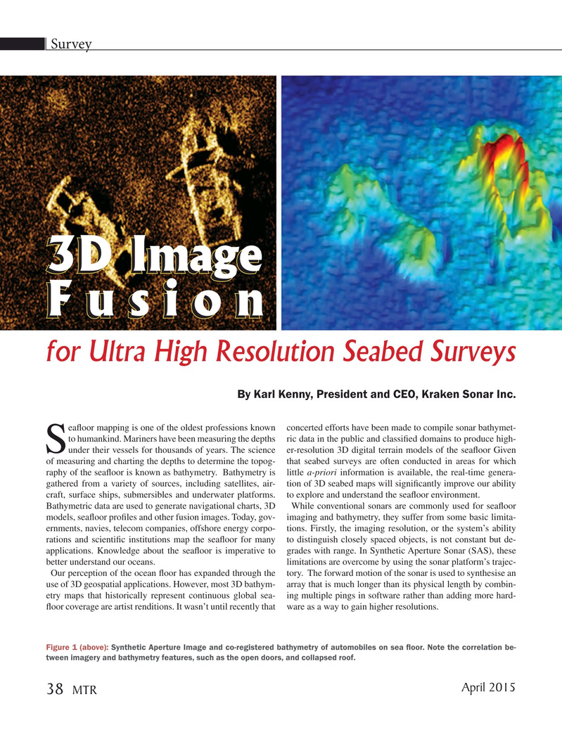
Figure 1 (above): Synthetic Aperture Image and co-registered bathymetry of automobiles on sea ? oor. Note the correlation be- tween imagery and bathymetry features, such as the open doors, and collapsed roof.
April 2015 38
MTR
MTR #3 (34-49).indd 38 MTR #3 (34-49).indd 38 4/6/2015 11:05:38 AM4/6/2015 11:05:38 AM