
Page 30: of Marine Technology Magazine (Mar/Apr 2016)
Oceanographic Instrumentation: Measurement, Process & Analysis
Read this page in Pdf, Flash or Html5 edition of Mar/Apr 2016 Marine Technology Magazine
 29
29
 31
31
Sea? oor Mapping better accuracy and coverage than all previous altimeters,” said Sandwell.
Global maps constructed using satellite-derived gravity data will never replace the ships. The resolution of this new method is limited by the ocean depth because the potential ? eld which gets smooth as you go from the bottom of the ocean to the surface. Whereas, the standard ship-based multi- beam echo-sounders resolves features on the sea? oor in high resolution about 100 meters across. The problem is in our lifetime we will probably never see the complete mapping of the sea? oor by ships. Which makes the satellite data vital to ? lling in the gaps.
The main challenges scientists face in developing these gravity ? eld models is improving the resolution from the sat- ellite altimetry data. Sea surface topography is a noisy mea- surement as the waves roughen the ocean’s surface making the range measurement less precise.
The Age of Charted Oceans
The two big areas of discoveries this model has already
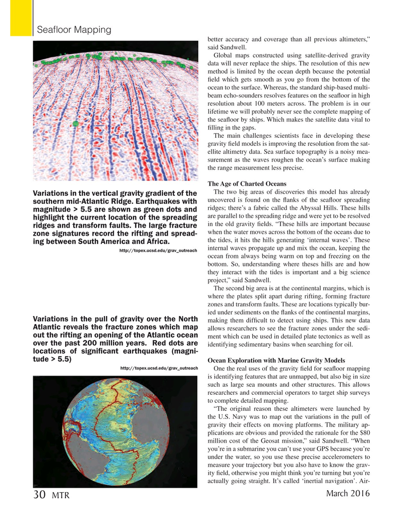
Variations in the vertical gravity gradient of the uncovered is found on the ? anks of the sea? oor spreading southern mid-Atlantic Ridge. Earthquakes with ridges; there’s a fabric called the Abyssal Hills. These hills magnitude > 5.5 are shown as green dots and are parallel to the spreading ridge and were yet to be resolved highlight the current location of the spreading in the old gravity ? elds. “These hills are important because ridges and transform faults. The large fracture when the water moves across the bottom of the oceans due to zone signatures record the rifting and spread- the tides, it hits the hills generating ‘internal waves’. These ing between South America and Africa.
internal waves propagate up and mix the ocean, keeping the http://topex.ucsd.edu/grav_outreach ocean from always being warm on top and freezing on the bottom. So, understanding where theses hills are and how they interact with the tides is important and a big science project,” said Sandwell.
The second big area is at the continental margins, which is where the plates split apart during rifting, forming fracture zones and transform faults. These are locations typically bur- ied under sediments on the ? anks of the continental margins,
Variations in the pull of gravity over the North making them dif? cult to detect using ships. This new data
Atlantic reveals the fracture zones which map allows researchers to see the fracture zones under the sedi- out the rifting an opening of the Atlantic ocean ment which can be used in detailed plate tectonics as well as over the past 200 million years. Red dots are identifying sedimentary basins when searching for oil. locations of signi? cant earthquakes (magni- tude > 5.5)
Ocean Exploration with Marine Gravity Models http://topex.ucsd.edu/grav_outreach
One the real uses of the gravity ? eld for sea? oor mapping is identifying features that are unmapped, but also big in size such as large sea mounts and other structures. This allows researchers and commercial operators to target ship surveys to complete detailed mapping. “The original reason these altimeters were launched by the U.S. Navy was to map out the variations in the pull of gravity their effects on moving platforms. The military ap- plications are obvious and provided the rationale for the $80 million cost of the Geosat mission,” said Sandwell. “When you’re in a submarine you can’t use your GPS because you’re under the water, so you use these precise accelerometers to measure your trajectory but you also have to know the grav- ity ? eld, otherwise you might think you’re turning but you’re actually going straight. It’s called ‘inertial navigation’. Air-
March 2016 30 MTR
MTR #2 (18-33).indd 30 2/19/2016 11:18:40 AM