Page 26: of Marine Technology Magazine (Jul/Aug 2017)
THE MTR 100 - 12th Annual Listing of 100 Leading Subsea Companies
Read this page in Pdf, Flash or Html5 edition of Jul/Aug 2017 Marine Technology Magazine
 25
25
 27
27
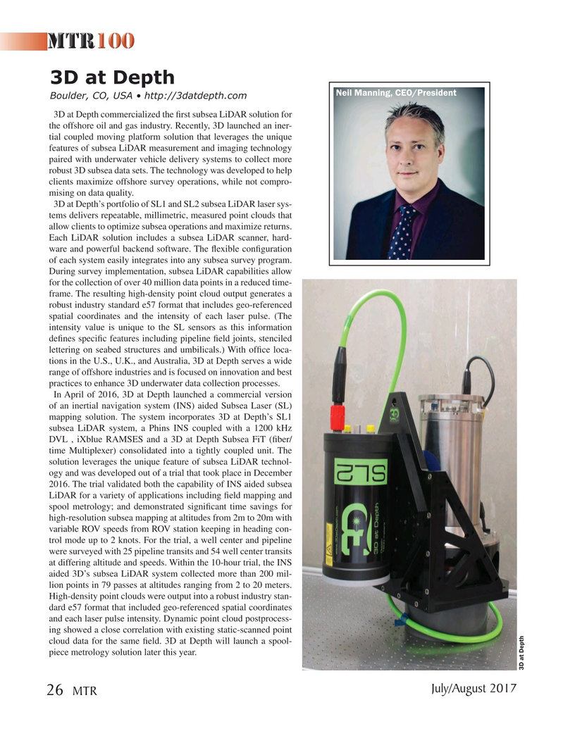
3D at Depth
Neil Manning, CEO/President
Boulder, CO, USA • http://3datdepth.com 3D at Depth commercialized the ? rst subsea LiDAR solution for the offshore oil and gas industry. Recently, 3D launched an iner- tial coupled moving platform solution that leverages the unique features of subsea LiDAR measurement and imaging technology paired with underwater vehicle delivery systems to collect more robust 3D subsea data sets. The technology was developed to help clients maximize offshore survey operations, while not compro- mising on data quality.
3D at Depth’s portfolio of SL1 and SL2 subsea LiDAR laser sys- tems delivers repeatable, millimetric, measured point clouds that allow clients to optimize subsea operations and maximize returns.
Each LiDAR solution includes a subsea LiDAR scanner, hard- ware and powerful backend software. The ? exible con? guration of each system easily integrates into any subsea survey program.
During survey implementation, subsea LiDAR capabilities allow for the collection of over 40 million data points in a reduced time- frame. The resulting high-density point cloud output generates a robust industry standard e57 format that includes geo-referenced spatial coordinates and the intensity of each laser pulse. (The intensity value is unique to the SL sensors as this information de? nes speci? c features including pipeline ? eld joints, stenciled lettering on seabed structures and umbilicals.) With of? ce loca- tions in the U.S., U.K., and Australia, 3D at Depth serves a wide range of offshore industries and is focused on innovation and best practices to enhance 3D underwater data collection processes.
In April of 2016, 3D at Depth launched a commercial version of an inertial navigation system (INS) aided Subsea Laser (SL) mapping solution. The system incorporates 3D at Depth’s SL1 subsea LiDAR system, a Phins INS coupled with a 1200 kHz
DVL , iXblue RAMSES and a 3D at Depth Subsea FiT (? ber/ time Multiplexer) consolidated into a tightly coupled unit. The solution leverages the unique feature of subsea LiDAR technol- ogy and was developed out of a trial that took place in December 2016. The trial validated both the capability of INS aided subsea
LiDAR for a variety of applications including ? eld mapping and spool metrology; and demonstrated signi? cant time savings for high-resolution subsea mapping at altitudes from 2m to 20m with variable ROV speeds from ROV station keeping in heading con- trol mode up to 2 knots. For the trial, a well center and pipeline were surveyed with 25 pipeline transits and 54 well center transits at differing altitude and speeds. Within the 10-hour trial, the INS aided 3D’s subsea LiDAR system collected more than 200 mil- lion points in 79 passes at altitudes ranging from 2 to 20 meters.
High-density point clouds were output into a robust industry stan- dard e57 format that included geo-referenced spatial coordinates and each laser pulse intensity. Dynamic point cloud postprocess- ing showed a close correlation with existing static-scanned point cloud data for the same ? eld. 3D at Depth will launch a spool- piece metrology solution later this year.
3D at Depth
July/August 2017 26 MTR
MTR #6 (18-33).indd 26 MTR #6 (18-33).indd 26 8/2/2017 11:13:41 AM8/2/2017 11:13:41 AM