Page 43: of Marine Technology Magazine (Sep/Oct 2017)
Ocean Observation: Gliders, Buoys & Sub-Surface Networks
Read this page in Pdf, Flash or Html5 edition of Sep/Oct 2017 Marine Technology Magazine
 42
42
 44
44
fully understand their reservoirs in an well placement that were unattainable improve wellbore stability and ef? cient and cost-effective manner. before — such as drilling in very thin, hole quality, and optimize well discontinued, or compartmentalized res- placement?
What are the main compo-
By seeing geological and reservoir ervoirs — can now be fully addressed. nents of the mapping-while- features deeper and earlier the wellbore The offshore Brazil case study dem- drilling service?
tortuosity is optimized and correction to onstrates how the reservoir mapping-
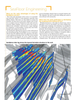
The main components of the service, the trajectory can be smoother and more while-drilling service investigated 100 which is adaptable to the challenges ef? cient. The outcome is a higher ROP ft from wellbore in real time to detect of the well, consist of separate drilling with a much improved wellbore position reservoir boundaries. As a result, the subs hosting electromagnetic transmit- with respect to the main reservoir target. operator accurately landed three wells, ters and receiver con? gured in a stan- each with multiple targets in channel dard bottom hole assemblydrill string. sands, leading to optimized drain trajec-
How and where is mapping-
When drilling, the data acquired by the tories. In the Balder ? eld, North Sea, while-drilling being used? system is transmitted onshore and pro- GeoSphere was ? rst used in the Cam- the GeoSphere service enabled the oper- cessed on a high power computer cluster pos basin, offshore Brazil, for landing, ator to eliminate the need for pilot holes to provide a continuous resistivity map pilot hole avoidance, and horizontal and improve landing success.
of the reservoir that helps the operator navigation by various operators, ac- In the Barents Sea, the GeoSphere to take well placement decisions in real counting for approximately 20% of the service revealed that the reservoir was time. total world application so far. thicker but more heterogeneous than
Two offshore case studies are worth anticipated—useful information for mentioning here. In the Balder ? eld, geosteering and for postwell evaluation
What were the bene? ts Sch-
North Sea, the GeoSphere reservoir activity.
lumberger found in using map- mapping-while-drilling service enabled ping-while-drilling?
the operator to eliminate the need for A close interaction with operators both
What does the future look like?
pilot holes and improve landing suc- during the pre-job phase and in real The service is rapidly becoming a stan- cess. The challenge was to distinguish time is paramount. The collaborative dard application to reduce drilling risks targeted sands from nontargeted sands approach enables the Schlumberger ex- and understand the reservoir to the full- when drilling through a complex for- perts to gain a much deeper understand- est. Such a service is needed as opera- mation to land effectively and optimize ing of the operator’s challenges from tors discover new opportunities and face production while eliminating the need landing to reservoir characterization. different challenges in the ever-chang- for costly pilot holes. Previous challenges associated with ing oil and gas environment.
The GeoSphere service mapped the top of the massive sands from more than 20-m [66-ft] true vertical depth above, ensuring a safer and more optimal land- ing result. Also, the operator was able to detect the oil/water contact while land- ing the 12 1/4-in section prior to pen- etrating the reservoir.
In the Caspian Sea, the GeoSphere service mapped formation boundar- ies that were located up to 24 m from the wellbore, allowing the operator to geosteer the well with only ? ve trajec- tory changes compared with an average 15-20 in previous wells. In this project,
Schlumberger achieved world record for the new service, logging 4,908 m in one run, 88.5% net to gross.
How does mapping-while-
Ph: (714) 546-3478 | www.secoseals.com | [email protected] drilling help increase ROP, www.marinetechnologynews.com
Marine Technology Reporter 43
MTR #7 (34-49).indd 43 MTR #7 (34-49).indd 43 8/23/2017 4:21:23 PM8/23/2017 4:21:23 PM