
Page 48: of Marine Technology Magazine (Jan/Feb 2018)
Underwater Vehicle Annual: ROVs, AUVs and UUVs
Read this page in Pdf, Flash or Html5 edition of Jan/Feb 2018 Marine Technology Magazine
 47
47
 49
49
Case Study 3DSS-DX-450 Sonar
Before coming to rest at the bottom of from Ping DSP mounted on a pole over to a catalog for later manipulation. Since
Lake Union in Washington, J.E. Boyden the side of a 27-ft. aluminum survey the saved data is three dimensional, ad- was a common sight along the shores of launch. The 3DSS sonar was mounted ditional views and measurements can be
Puget Sound and Vancouver Island. The at a depth of 0.75 meters and the survey made, color scales adjusted and results 85-ft. vessel served as a cargo hauler was conducted at a speed of three knots. can be exported for import into third and tug vessel for almost half a century A single pass over the J.E. Boyden with party software.
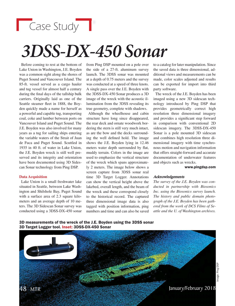
during the ? nal days of the tallship bulk the 3DSS-DX-450 Sonar produces a 3D The wreck of the J.E. Boyden has been carriers. Originally laid as one of the image of the wreck with the acoustic il- imaged using a new 3D sidescan tech-
Seattle steamer ? eet in 1888, the Boy- lumination from the 3DSS revealing its nology introduced by Ping DSP that den quickly made a name for herself as true geometry, complete with shadows. provides geometrically correct high a powerful and capable tug, transporting Although the wheelhouse and cabin resolution three dimensional imagery coal, coke and lumber between ports on structure have long since disappeared, and provides a signi? cant step forward
Vancouver Island and Puget Sound. The the rear deck and ornate woodwork bor- in comparison with conventional 2D
J.E. Boyden was also involved for many dering the stern is still very much intact, sidescan imagery. The 3DSS-DX-450 years as a tug for sailing ships entering as are the bow and the decks surround- Sonar is a pole mounted 3D sidescan the variable waters of the Strait of Juan ing the well de? ned hold. The image and combines high resolution three di- de Fuca and Puget Sound. Scuttled in shows the J.E. Boyden lying in 12.46 mensional imagery with time synchro- 1935 in 40 ft. of water in Lake Union, meters water depth surrounded by ? at, nous motion and navigation information the J.E. Boyden wreck is still well pre- muddy terrain. Colors in the image are that offers straight-forward and accurate served and its integrity and orientation used to emphasize the vertical structure documentation of underwater features have been documented using 3D Sides- of the wreck which spans approximate- and objects such as wrecks.
can Sonar technology from Ping DSP. ly 2 meters. The image below shows a www.pingdsp.com screen capture from 3DSS sonar real
Data Acquisition time 3D Target Logger. Annotations Acknowledgements
Lake Union is a small freshwater lake can show the vertical height above the The survey of the J.E. Boyden was con- situated in Seattle, between Lake Wash- lakebed, overall length, and the beam of ducted in partnership with Biosonics ington and Shilshole Bay, Puget Sound the wreck and these correspond closely Inc. using the Biosonics survey launch. with a surface area of 2.3 square kilo- to the historical record. The captured The history and public domain photo- meters and an average depth of 10 me- three dimensional image data is also graph of the J.E. Boyden has been gath- ters. The 3D Sidescan Sonar survey was tagged with position information, ping ered from the work of DCS Films of Se- conducted using a 3DSS-DX-450 sonar numbers and time and can also be saved attle and the U. of Washington archives. 3D measurements of the wreck of the J.E. Boyden using the 3DSS sonar 3D Target Logger tool. Inset: 3DSS-DX-450 Sonar
Image: Ping DSP
January/February 2018 48
MTR
MTR #1 (34-49).indd 48 MTR #1 (34-49).indd 48 1/25/2018 1:38:48 PM1/25/2018 1:38:48 PM