Page 44: of Marine Technology Magazine (Nov/Dec 2019)
MTR White Papers: Subsea Vehicles
Read this page in Pdf, Flash or Html5 edition of Nov/Dec 2019 Marine Technology Magazine
 43
43
 45
45
Remote Sensing Riverine Exploration
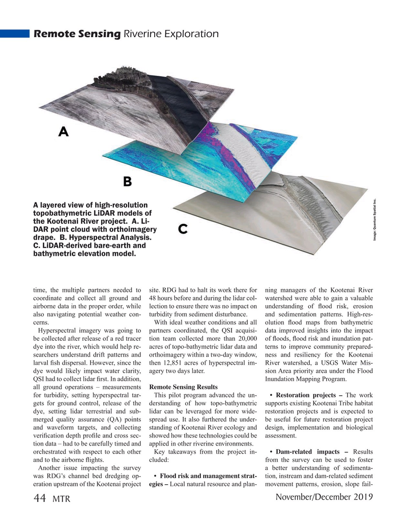
A layered view of high-resolution topobathymetric LiDAR models of the Kootenai River project. A. Li-
DAR point cloud with orthoimagery drape. B. Hyperspectral Analysis.
Image: Quantum Spatial Inc.
C. LiDAR-derived bare-earth and bathymetric elevation model. time, the multiple partners needed to site. RDG had to halt its work there for ning managers of the Kootenai River coordinate and collect all ground and 48 hours before and during the lidar col- watershed were able to gain a valuable airborne data in the proper order, while lection to ensure there was no impact on understanding of ? ood risk, erosion also navigating potential weather con- turbidity from sediment disturbance. and sedimentation patterns. High-res- cerns. With ideal weather conditions and all olution ? ood maps from bathymetric
Hyperspectral imagery was going to partners coordinated, the QSI acquisi- data improved insights into the impact be collected after release of a red tracer tion team collected more than 20,000 of ? oods, ? ood risk and inundation pat- dye into the river, which would help re- acres of topo-bathymetric lidar data and terns to improve community prepared- searchers understand drift patterns and orthoimagery within a two-day window, ness and resiliency for the Kootenai larval ? sh dispersal. However, since the then 12,851 acres of hyperspectral im- River watershed, a USGS Water Mis- dye would likely impact water clarity, agery two days later. sion Area priority area under the Flood
QSI had to collect lidar ? rst. In addition, Inundation Mapping Program. all ground operations – measurements Remote Sensing Results for turbidity, setting hyperspectral tar- This pilot program advanced the un- • Restoration projects – The work gets for ground control, release of the derstanding of how topo-bathymetric supports existing Kootenai Tribe habitat dye, setting lidar terrestrial and sub- lidar can be leveraged for more wide- restoration projects and is expected to merged quality assurance (QA) points spread use. It also furthered the under- be useful for future restoration project and waveform targets, and collecting standing of Kootenai River ecology and design, implementation and biological veri? cation depth pro? le and cross sec- showed how these technologies could be assessment.
tion data – had to be carefully timed and applied in other riverine environments. orchestrated with respect to each other Key takeaways from the project in- • Dam-related impacts – Results and to the airborne ? ights. cluded: from the survey can be used to foster
Another issue impacting the survey a better understanding of sedimenta- was RDG’s channel bed dredging op- • Flood risk and management strat- tion, instream and dam-related sediment eration upstream of the Kootenai project egies – Local natural resource and plan- movement patterns, erosion, slope fail-
November/December 2019 44
MTR
MTR #9 (34-49).indd 44 12/2/2019 11:28:17 AM