Page 10: of Marine Technology Magazine (May/Jun 2022)
Read this page in Pdf, Flash or Html5 edition of May/Jun 2022 Marine Technology Magazine
 9
9
 11
11
Eye on the Navy Sonar
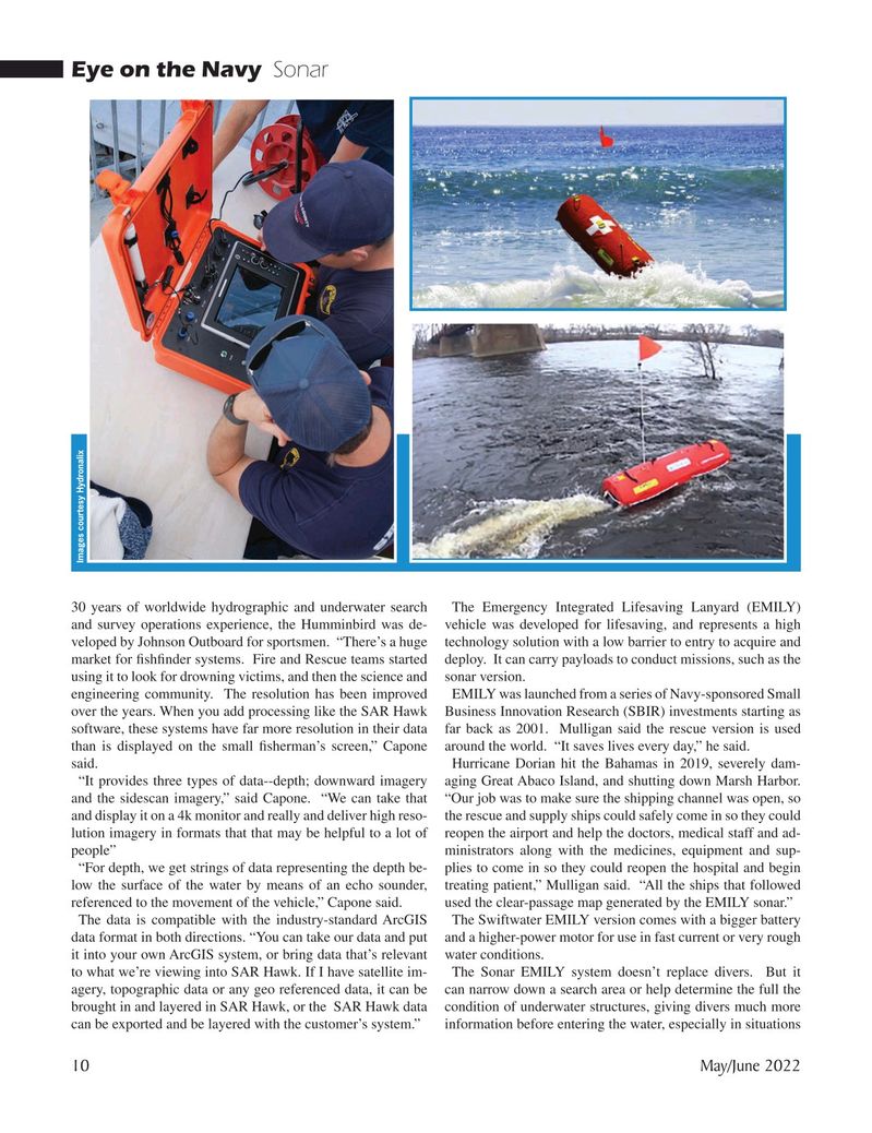
Images courtesy Hydronalix 30 years of worldwide hydrographic and underwater search The Emergency Integrated Lifesaving Lanyard (EMILY) and survey operations experience, the Humminbird was de- vehicle was developed for lifesaving, and represents a high veloped by Johnson Outboard for sportsmen. “There’s a huge technology solution with a low barrier to entry to acquire and market for ? sh? nder systems. Fire and Rescue teams started deploy. It can carry payloads to conduct missions, such as the using it to look for drowning victims, and then the science and sonar version.
engineering community. The resolution has been improved EMILY was launched from a series of Navy-sponsored Small over the years. When you add processing like the SAR Hawk Business Innovation Research (SBIR) investments starting as software, these systems have far more resolution in their data far back as 2001. Mulligan said the rescue version is used than is displayed on the small ? sherman’s screen,” Capone around the world. “It saves lives every day,” he said.
said. Hurricane Dorian hit the Bahamas in 2019, severely dam- “It provides three types of data--depth; downward imagery aging Great Abaco Island, and shutting down Marsh Harbor. and the sidescan imagery,” said Capone. “We can take that “Our job was to make sure the shipping channel was open, so and display it on a 4k monitor and really and deliver high reso- the rescue and supply ships could safely come in so they could lution imagery in formats that that may be helpful to a lot of reopen the airport and help the doctors, medical staff and ad- people” ministrators along with the medicines, equipment and sup- “For depth, we get strings of data representing the depth be- plies to come in so they could reopen the hospital and begin low the surface of the water by means of an echo sounder, treating patient,” Mulligan said. “All the ships that followed referenced to the movement of the vehicle,” Capone said. used the clear-passage map generated by the EMILY sonar.”
The data is compatible with the industry-standard ArcGIS The Swiftwater EMILY version comes with a bigger battery data format in both directions. “You can take our data and put and a higher-power motor for use in fast current or very rough it into your own ArcGIS system, or bring data that’s relevant water conditions.
to what we’re viewing into SAR Hawk. If I have satellite im- The Sonar EMILY system doesn’t replace divers. But it agery, topographic data or any geo referenced data, it can be can narrow down a search area or help determine the full the brought in and layered in SAR Hawk, or the SAR Hawk data condition of underwater structures, giving divers much more can be exported and be layered with the customer’s system.” information before entering the water, especially in situations 10 May/June 2022
MTR #4 (1-17).indd 10 4/28/2022 2:28:31 PM