Page 12: of Marine Technology Magazine (May/Jun 2022)
Read this page in Pdf, Flash or Html5 edition of May/Jun 2022 Marine Technology Magazine
 11
11
 13
13
CASE STUDY
Acoustic remote sensing for underwater archaeology
High resolution multibeam mapping of the submerged city of Baia, Italy
The greatest archaeological treasures are not only hidden be- imaging with centimetric resolution using multibeam sonar low the ground but many of them remain below water, on the gives a wide and comprehensive picture of underwater sites seabed and beneath. This is the case of the submerged city of of cultural interest.
Baia located in the Gulf of Pozzuoli in the western part of the The survey carried out on 8 m long motorboat r/v ULISSE
Bay of Naples (Italy). It was a famous and fashionable resort during two days of data acquisition, using the WINGHEAD city in Roman times, with luxury villas and baths with hot i77h, the new high-resolution multibeam sonar system from springs. Mostly of the city was submerged between the 3rd Norbit.
and 8th century AD due to vertical ground movements induced A 10 cm DTM is the ? rst result of the high data density and by a local volcanic phenomena known as “Bradydeism”. To resolution acquired, a primary record of the current state of protect this, in 2002 the underwater site of Baia was desig- the submerged archaeological features. The extreme details nated as Marine Archaeological Park and Marine Protected and accuracy obtained will help to re? ne the overall mapping
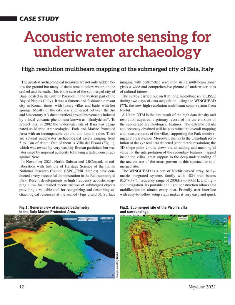
Area with an incomparable cultural and natural value. There and measurements of the villas, supporting the Park monitor- are several underwater archaeological assets ranging from ing and preservation. Moreover, thanks to the ultra-high reso- 5 to 13m of depth. One of them is Villa dei Pisoni (Fig. 1), lution of the xyz real data detected (centimetric resolution) the which was owned by very wealthy Roman patricians but was 3D shape point clouds views are an adding and meaningful later sized by imperial authority following a failed conspiracy value for the interpretation of the secondary features mapped against Nero. inside the villas, great support to the deep understanding of
In November 2021, Norbit Subsea and 2BControl, in col- the ancient use of the areas present in this spectacular sub- laboration with Institute of Heritage Science of the Italian merged site.
National Research Council (ISPC_CNR, Naples) have con- The WINGHEAD is a part of Norbit curved array, bathy- ducted a very successful demonstration in the Baia submerged metric integrated systems family with 1024 true beams
Park. Recent developments in high frequency acoustic map- (0.5°x0.9°), frequency range of 200kHz to 700kHz and high- ping allow for detailed reconstruction of submerged objects end navigation. Its portable and light construction allows fast providing a valuable tool for recognizing and describing ar- mobilization on almost every boat. Friendly user interface chaeological resources at the seabed (Figs 2 and 3). Surface with easy-to-follow setup steps makes it very easy and quick
Fig.1. General view of mapped bathymetry Fig.2. Submerged site of the Pisoni’s villa in the Baia Marine Protected Area. and surroundings.
Images courtesy Norbit 12 May/June 2022
MTR #4 (1-17).indd 12 4/28/2022 2:41:26 PM