
Page 25: of Marine Technology Magazine (Mar/Apr 2024)
Read this page in Pdf, Flash or Html5 edition of Mar/Apr 2024 Marine Technology Magazine
 24
24
 26
26
Auerbach explained that ideally, “one ? ed layers of geothermal activity,” noted changes over an area of 8,000 km2. They would have both instruments: seismom- Skett, “and the change in salinity and dis- found up to seven km3 of displaced ma- eters to detect and locate subsurface ac- solved particles for comparison studies terial from the sea? oor, according to a tivity, and hydrophones to study activity against samples gathered by RV Tanga- NIWA statement from November 2022. that couples into the water column.” roa outside the caldera.” In all, Maxlimer Tonga’s severed domestic internet cable mapped more than 800 km2 and travelled was buried under 30 m of ash and sedi-
TESMaP Makes it Mark 1331 nautical miles over 34 days. ment, added Skett. Impacts on the eco-
In April 2022, four months after HT-HH system differed; the volcano was devoid erupted, scientists from NIWA and the of biology but features as close as 15 km Surfacing Subsea
Discoveries
Nippon Foundation of Japan mobilized away still had abundant life, including the Tonga Eruption Seabed Mapping Even before the recent HT-HH erup- corals, sponges, star? sh and mussels.
Project (TESMaP) to understand the ex- tion, subsea technology helped scien- This indicated the resilience of certain tent of impact and inform future manage- tists uncover the behaviors of underwa- marine ecosystems, providing a new ment and recovery both in Tonga and the ter volcanoes. “We can use hydrophones baseline for monitoring future recovery. wider Paci? c Ocean. Mackay, who spe- to detect submarine landslides as well “Preliminary water column data from cializes in sea? oor mapping techniques, as earthquakes and eruptions,” said Maxlimer show airborne ash that had served as voyage lead. Phase one saw the Caplan-Auerbach, whose work has pri- yet to completely settle on the sea? oor,” scientist aboard RV Tangaroa, surveying marily focused on Kama`ehuakanaloa said Skett. “There was also evidence to the oceans around HT-HH and collecting (formerly known as Lo`ihi, the youngest suggest the volcano was still erupting, video images of the eruption’s impact. volcano in Hawai`i) and West Mata vol- with a dense ash layer found in the up-
Equipment on board included a deep- cano in the Tonga arc. “We’ve seen a ton per water column near the site.” towed imaging system, multicorer, CTD of landslides in acoustic data recorded (conductivity, temperature, depth), and off Kilauea and West Mata. Before that Known Unknowns autonomous ocean glider. Mackay’s fa- discovery, we had no idea how to tell if Much remains unknown about subma- vorite was the multibeam echo sounder, an undersea landslide had occurred.” rine volcanoes, explained Mackay, as re- generating 3D images of the sea? oor us- At HT-HH, scientists mapped a total of searchers return to the eruption site more ing beams of sound waves. “This is the 22,000 km2 of the sea? oor and observed than two years later to gather additional only way we can see what the sea? oor looks like,” he said. “To some degree it makes me feel like an explorer—the ? rst
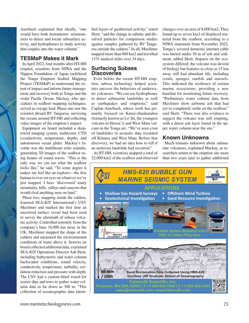
HMS-620 BUBBLE GUN human to ever set eyes on whatever we’ve
MARINE SEISMIC SYSTEM just mapped. I have ‘discovered’ many mountains, hills, valleys and canyons that APPLICATIONS would rival anything seen on land.” • Shallow Gas Hazard Surveys • Oi shore Wind Turbine
Phase two, mapping inside the caldera, • Geotechnical InvesO gaO on • Sand Resource InvesO gaO on featured SEA-KIT International’s USV
Maxlimer and marked the ? rst time an uncrewed surface vessel had been used to survey the aftermath of subsea volca- nic activity. Controlled remotely from the company’s base 16,000 km away in the
Portable System Requires only
UK, Maxlimer mapped the shape of the
Wavelet 2KW at 250ms Ping Rate
CorrelaO on > 0.96 caldera and measured the environmental conditions of water above it. Sensors on board collected additional data, explained
SEA-KIT Operations Director Ash Skett, including bathymetric and water column backscatter conditions, sound velocity, conductivity, temperature, turbidity, oxi- dation reduction and pressure with depth.
Sand Reclamation Data Collected Using HMS-620
Courtesy URI Graduate School of Oceanography
The USV had a custom-? tted winch for sensor dips and tows to gather water col- Falmouth Scienti¿ c, Inc.
Pocasset, MA USA 02559 | T:+1-508-564-7640 | F:+1-508-564-7643 umn data as far down as 300 m. “This [email protected] • www.falmouth.com collection of oceanographic data identi- www.marinetechnologynews.com 25
MTR #3 (18-33).indd 25 4/4/2024 2:00:10 PM