
Page 35: of Marine Technology Magazine (May/Jun 2024)
Read this page in Pdf, Flash or Html5 edition of May/Jun 2024 Marine Technology Magazine
 34
34
 36
36
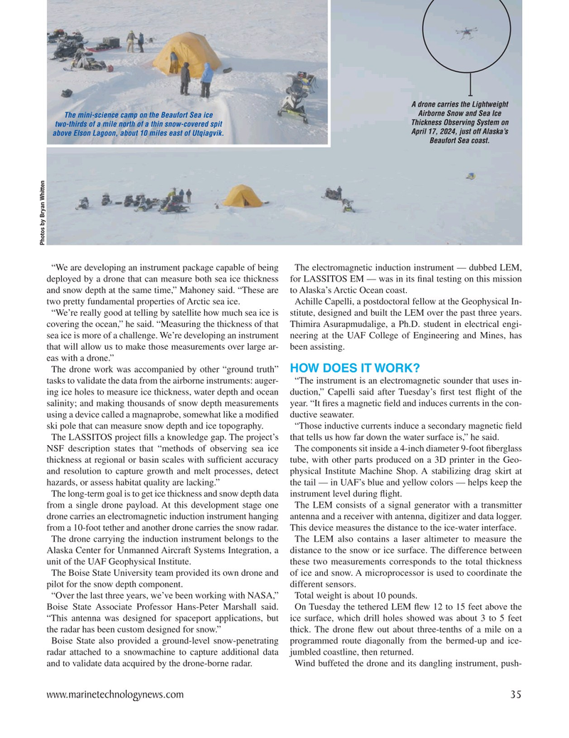
A drone carries the Lightweight
Airborne Snow and Sea Ice
The mini-science camp on the Beaufort Sea ice
Thickness Observing System on two-thirds of a mile north of a thin snow-covered spit
April 17, 2024, just off Alaska’s above Elson Lagoon, about 10 miles east of Utqiagvik.
Beaufort Sea coast.
Photos by Bryan Whitten “We are developing an instrument package capable of being The electromagnetic induction instrument — dubbed LEM, deployed by a drone that can measure both sea ice thickness for LASSITOS EM — was in its ? nal testing on this mission and snow depth at the same time,” Mahoney said. “These are to Alaska’s Arctic Ocean coast.
two pretty fundamental properties of Arctic sea ice. Achille Capelli, a postdoctoral fellow at the Geophysical In- “We’re really good at telling by satellite how much sea ice is stitute, designed and built the LEM over the past three years. covering the ocean,” he said. “Measuring the thickness of that Thimira Asurapmudalige, a Ph.D. student in electrical engi- sea ice is more of a challenge. We’re developing an instrument neering at the UAF College of Engineering and Mines, has that will allow us to make those measurements over large ar- been assisting.
eas with a drone.”
The drone work was accompanied by other “ground truth” HOW DOES IT WORK?
tasks to validate the data from the airborne instruments: auger- “The instrument is an electromagnetic sounder that uses in- ing ice holes to measure ice thickness, water depth and ocean duction,” Capelli said after Tuesday’s ? rst test ? ight of the salinity; and making thousands of snow depth measurements year. “It ? res a magnetic ? eld and induces currents in the con- using a device called a magnaprobe, somewhat like a modi? ed ductive seawater. ski pole that can measure snow depth and ice topography. “Those inductive currents induce a secondary magnetic ? eld
The LASSITOS project ? lls a knowledge gap. The project’s that tells us how far down the water surface is,” he said.
NSF description states that “methods of observing sea ice The components sit inside a 4-inch diameter 9-foot ? berglass thickness at regional or basin scales with suf? cient accuracy tube, with other parts produced on a 3D printer in the Geo- and resolution to capture growth and melt processes, detect physical Institute Machine Shop. A stabilizing drag skirt at hazards, or assess habitat quality are lacking.” the tail — in UAF’s blue and yellow colors — helps keep the
The long-term goal is to get ice thickness and snow depth data instrument level during ? ight.
from a single drone payload. At this development stage one The LEM consists of a signal generator with a transmitter drone carries an electromagnetic induction instrument hanging antenna and a receiver with antenna, digitizer and data logger. from a 10-foot tether and another drone carries the snow radar. This device measures the distance to the ice-water interface.
The drone carrying the induction instrument belongs to the The LEM also contains a laser altimeter to measure the
Alaska Center for Unmanned Aircraft Systems Integration, a distance to the snow or ice surface. The difference between unit of the UAF Geophysical Institute. these two measurements corresponds to the total thickness
The Boise State University team provided its own drone and of ice and snow. A microprocessor is used to coordinate the pilot for the snow depth component. different sensors.
“Over the last three years, we’ve been working with NASA,” Total weight is about 10 pounds.
Boise State Associate Professor Hans-Peter Marshall said. On Tuesday the tethered LEM ? ew 12 to 15 feet above the “This antenna was designed for spaceport applications, but ice surface, which drill holes showed was about 3 to 5 feet the radar has been custom designed for snow.” thick. The drone ? ew out about three-tenths of a mile on a
Boise State also provided a ground-level snow-penetrating programmed route diagonally from the bermed-up and ice- radar attached to a snowmachine to capture additional data jumbled coastline, then returned.
and to validate data acquired by the drone-borne radar. Wind buffeted the drone and its dangling instrument, push- www.marinetechnologynews.com 35
MTR #4 (34-47).indd 35 6/2/2024 11:43:33 AM