Page 55: of Maritime Reporter Magazine (June 1985)
Read this page in Pdf, Flash or Html5 edition of June 1985 Maritime Reporter Magazine
 54
54
 56
56
ADVERTISEMENT
Operate 365 Days a Year with Greater Efficiency,
Safety and Profits
Until now, ice, bad weather and poor visibility made navigation dangerous, and at times, impossi- ble. A remarkable new break- through called the VIEWNAV™Sys- e * •4 A • _ •
The VIEWNAV System combines micro- processor technology with a detailed Elec- tronic Chart, radar images and Differential
Loran-C positioning. Its razor-sharp navi- gational window accurately displays all the information needed to keep the ship safe and on course, even in ice, bad weather and visibility.
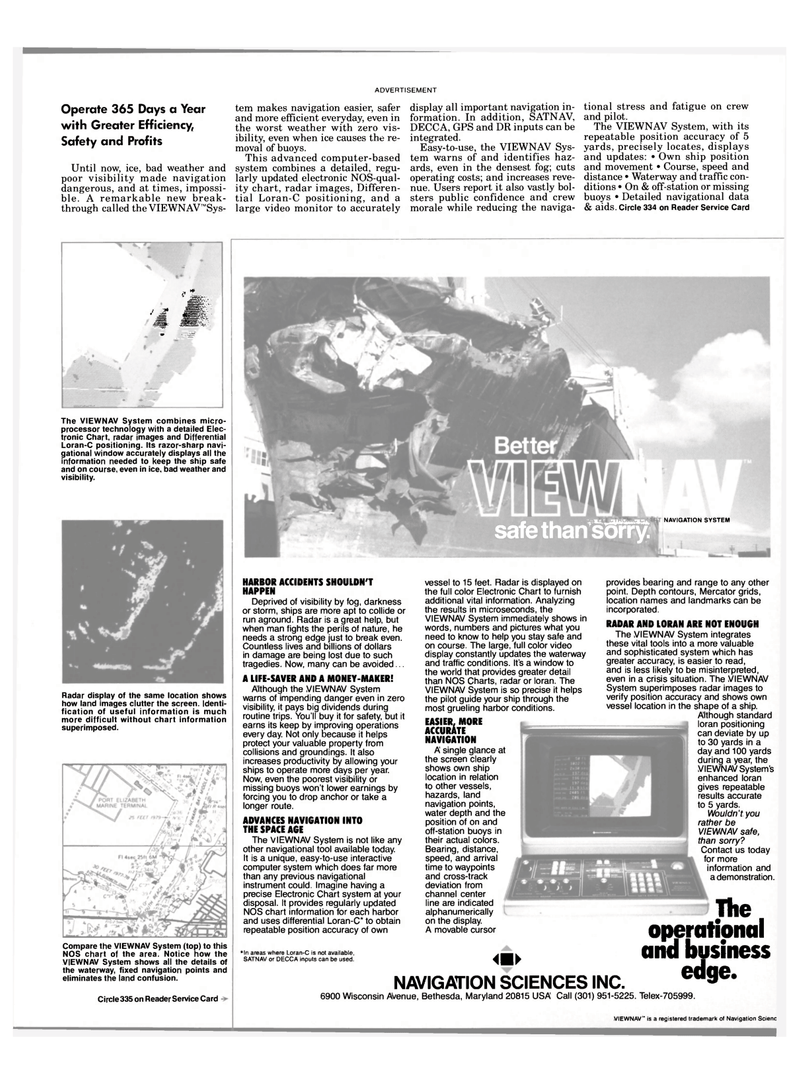
Radar display of the same location shows how land images clutter the screen. Identi- fication of useful information is much more difficult without chart information superimposed. tem makes navigation easier, safer and more efficient everyday, even in the worst weather with zero vis- ibility, even when ice causes the re- moval of buoys.
This advanced computer-based system combines a detailed, regu- larly updated electronic NOS-qual- ity chart, radar images, Differen- tial Loran-C positioning, and a large video monitor to accurately display all important navigation in- formation. In addition, SATNAV,
DECCA, GPS and DR inputs can be integrated.
Easy-to-use, the VIEWNAV Sys- tem warns of and identifies haz- ards, even in the densest fog; cuts operating costs; and increases reve- nue. Users report it also vastly bol- sters public confidence and crew morale while reducing the naviga- tional stress and fatigue on crew and pilot.
The VIEWNAV System, with its repeatable position accuracy of 5 yards, precisely locates, displays and updates: • Own ship position and movement • Course, speed and distance • Waterway and traffic con- ditions • On & off-station or missing buoys • Detailed navigational data & aids. Circle 334 on Reader Service Card r . | am 5fc safe than sorry. NAVIGATION SYSTEM
Compare the VIEWNAV System (top) to this
NOS chart of the area. Notice how the
VIEWNAV System shows all the details of the waterway, fixed navigation points and eliminates the land confusion.
Circle 335 on Reader Service Card 6900 Wisconsin Avenue, Bethesda, Maryland 20815 USA Call (301) 951-5225. Telex-705999.
HARBOR ACCIDENTS SHOULDN'T
HAPPEN
Deprived of visibility by fog, darkness or storm, ships are more apt to collide or run aground. Radar is a great help, but when man fights the perils of nature, he needs a strong edge just to break even.
Countless lives and billions of dollars in damage are being lost due to such tragedies. Now, many can be avoided...
A LIFE-SAVER AND A MONEY-MAKER!
Although the VIEWNAV System warns of impending danger even in zero visibility, it pays big dividends during routine trips. You'll buy it for safety, but it earns its keep by improving operations every day. Not only because it helps protect your valuable property from collisions and groundings. It also increases productivity by allowing your ships to operate more days per year.
Now, even the poorest visibility or missing buoys won't lower earnings by forcing you to drop anchor or take a longer route.
ADVANCES NAVIGATION INTO
THE SPACE AGE
The VIEWNAV System is not like any other navigational tool available today.
It is a unique, easy-to-use interactive computer system which does far more than any previous navigational instrument could. Imagine having a precise Electronic Chart system at your disposal. It provides regularly updated
NOS chart information for each harbor and uses differential Loran-C* to obtain repeatable position accuracy of own vessel to 15 feet. Radar is displayed on the full color Electronic Chart to furnish additional vital information. Analyzing the results in microseconds, the
VIEWNAV System immediately shows in words, numbers and pictures what you need to know to help you stay safe and on course. The large, full color video display constantly updates the waterway and traffic conditions. It's a window to the world that provides greater detail than NOS Charts, radar or loran. The
VIEWNAV System is so precise it helps the pilot guide your ship through the most grueling harbor conditions.
EASIER, MORE
ACCURATE
NAVIGATION
A single glance at the screen clearly shows own ship location in relation to other vessels, hazards, land navigation points, water depth and the position of on and off-station buoys in their actual colors.
Bearing, distance, speed, and arrival time to waypoints and cross-track deviation from channel center line are indicated alphanumerically on the display.
A movable cursor *ln areas where Loran-C is not available,
SATNAV or DECCA inputs can be used. NAVIGATION SCIENCES
provides bearing and range to any other
point. Depth contours, Mercator grids,
location names and landmarks can be
incorporated.
RADAR AND LORAN ARE NOT ENOUGH
The VIEWNAV System integrates
these vital tools into a more valuable
and sophisticated system which has
greater accuracy, is easier to read,
and is less likely to be misinterpreted,
even in a crisis situation. The VIEWNAV
System superimposes radar images to
verify position accuracy and shows own
vessel location in the shape of a ship.
Although standard
loran positioning
can deviate by up
to 30 yards in a
day and 100 yards
during a year, the
VIEWNAV System's
enhanced loran
gives repeatable
results accurate
to 5 yards.
Wouldn't you
rather be
VIEWNAV safe,
than sorry?
Contact us today
for more
information and
a demonstration.
The operational
and business edge.
INC.
VIEWNAV " is a registered trademark of Navigation Scienc
