Page 13: of Maritime Reporter Magazine (September 15, 1994)
Read this page in Pdf, Flash or Html5 edition of September 15, 1994 Maritime Reporter Magazine
 12
12
 14
14
Ginther Named President
Of Michigan Wheel's
Coolidge Division
American Marine Gets $390,000 Contract For
Two Cutterhead Dredges
American Marine and Machinery
Company (AMMCO) of Nashville has been awarded a contract worth about $390,000 to supply two cut- terhead suction dredging machines to the South Dakota Department of
Water and Natural Resources.
AMMCO management personnel were given the contract in Pierre,
S.D., recently following a meeting with Governor William Janklow.
In attendance on behalf of AMMCO were president Don R. King and vice presidents David Binkley and Allen Cargile.
The specially designed "canal" type dredges are to be delivered to the State agency in Aberdeen, S.D.
They will be used for the dredging of the James River over a distance of approximately 265 miles. The
James River Channel Project is a combined flood control and irriga- tion project. It is estimated that some three million cubic yards of sediment will be removed from the river channel.
AMMCO, one of the pioneers of the portable hydraulic dredge, built its first canal type machine more than 20 years ago for the U.S. Army
Corp of Engineers; that dredge is still in service.
Harry Ginther
Herbert L. VanderMey, presi- dent of Michigan Wheel Corpora- tion of Grand Rapids, Mich., has announced a reorganization of the company, and the formation of a new division to be called Coolidge
Propeller Commercial. The division president is Harry Ginther, who was formerly general manager of
Coolidge Propeller. He will have added responsibilities of Michigan
Wheel operations in Seattle and
Pascagoula, Miss.
Coolidge Propellers, with 55 years of marine propeller and related equipment experience, will operate from its present location in Seattle.
Coolidge manufactures propellers up to 14 feet diameter in stainless steel, and up to 40 feet diameter in manganese bronze and nibral alloys.
Propeller shafts and other marine hardware will also be available from the Coolidge division.
Circle 44 on Reader Service Card
USP&I Home Office
To New York Area—
Other Changes Announced
The United States P.&I. Agency,
Inc. (USP&I), the marine liability claims adjusting affiliate of Under- writers Adjusting Company, has an- nounced changes in office locations and management responsibilities.
The home office, formerly located in
New Orleans, has moved to Piscata- way, N.J. A new branch office has been opened in Tampa, Fla., and the Boston branch office has been opened in Tampa, Fla., and the Bos- ton branch has relocated to Ports- mouth, N.H.
James L. Lewis, executive ad- juster, is branch manager at Tampa, and Robert Hefler is branch man- ager at Portsmouth. George Goj- dics has been named manager of the New York City branch office, and Carter C. James has been appointed manager of the Norfolk office. Therese Carter has been named senior adjuster, operating in
St. Louis.
USP&I, specializing in marine lia- bility claims for more than 50 years, provides claims services to domestic and international underwriters and their agents, as well as to shipown- ers and offshore vessel operators, commercial fishing vessels, and yachts.
For further information on
USP&I's services,
Circle 34 on Reader Service Card
Circle 196 on Reader Service Card •> 6900 Wisconsin Avenue, Bethesda, Maryland 20815 USA Call (301) 951-5225. Telex-705999.
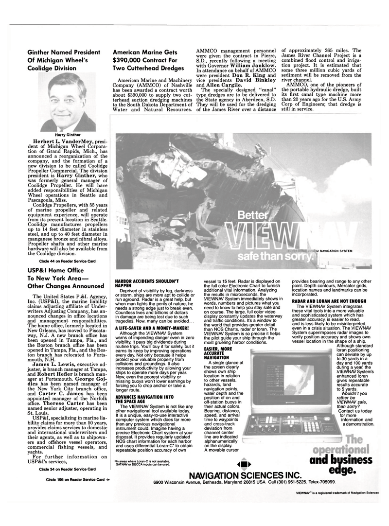
IT NAVIGATION SYSTEM
HARBOR ACCIDENTS SHOULDN'T
HAPPEN
Deprived of visibility by fog, darkness or storm, ships are more apt to collide or run aground. Radar is a great help, but when man fights the perils of nature, he needs a strong edge just to break even.
Countless lives and billions of dollars in damage are being lost due to such tragedies. Now, many can be avoided...
A LIFE-SAVER AND A MONEY-MAKER!
Although the VIEWNAV System warns of impending danger even in zero visibility, it pays big dividends during routine trips. You'll buy it for safety, but it earns its keep by improving operations every day. Not only because it helps protect your valuable property from collisions and groundings. It also increases productivity by allowing your ships to operate more days per year.
Now, even the poorest visibility or missing buoys won't lower earnings by forcing you to drop anchor or take a longer route.
ADVANCES NAVIGATION INTO
THE SPACE AGE
The VIEWNAV System is not like any other navigational tool available today.
It is a unique, easy-to-use interactive computer system which does far more than any previous navigational instrument could. Imagine having a precise Electronic Chart system at your disposal. It provides regularly updated
NOS chart information for each harbor and uses differential Loran-C* to obtain repeatable position accuracy of own vessel to 15 feet. Radar is displayed on the full color Electronic Chart to furnish additional vital information. Analyzing the results in microseconds, the
VIEWNAV System immediately shows in words, numbers and pictures what you need to know to help you stay safe and on course. The large, full color video display constantly updates the waterway and traffic conditions. It's a window to the world that provides greater detail than NOS Charts, radar or loran. The
VIEWNAV System is so precise it helps the pilot guide your ship through the most grueling harbor conditions.
EASIER, MORE
ACCURATE
NAVIGATION
A single glance at the screen clearly shows own ship location in relation to other vessels, hazards, land navigation points, water depth and the position of on and off-station buoys in their actual colors.
Bearing, distance, speed, and arrival time to waypoints and cross-track deviation from channel center line are indicated alphanumerically on the display.
A movable cursor provides bearing and range to any other point. Depth contours, Mercator grids, location names and landmarks can be incorporated.
RADAR AND LORAN ARE NOT ENOUGH
The VIEWNAV System integrates these vital tools into a more valuable and sophisticated system which has greater accuracy, is easier to read, and is less likely to be misinterpreted, even in a crisis situation. The VIEWNAV
System superimposes radar images to verify position accuracy and shows own vessel location in the shape of a ship.
Although standard loran positioning can deviate by up to 30 yards in a day and 100 yards during a year, the
VIEWNAV System's enhanced loran gives repeatable results accurate to 5 yards.
Wouldn't you rather be
VIEWNAV safe, than sorry?
Contact us today for more information and a demonstration. *ln areas where Loran-C is not available.
SATNAV or DECCA inputs can be used. NAVIGATION SCIENCES INC.
and business edge.
VIEWNAV" is a registered trademark of Navigation Sciences
