Page 36: of Maritime Reporter Magazine (March 1995)
Read this page in Pdf, Flash or Html5 edition of March 1995 Maritime Reporter Magazine
 35
35
 37
37
USCG DGPS Navigation Service
By Gene W. Hall, LCDR, USCG
DGPS Operations Officer
U.S. Coast Guard Navigation Center
MARINE ELECTRONICS YEARBOOK
The U.S. Coast Guard (USCG) is working to pro-vide Differential Global Po sitioning System (DGPS) service for harbor and harbor ap- proach navigation by 1996. DGPS technology is the first to economi- cally offer geodetic accuracy meet- ing the federal planning require- ment of 26.2 to 65.6 ft. (eight to 20 m) for harbor and harbor approach navigation.
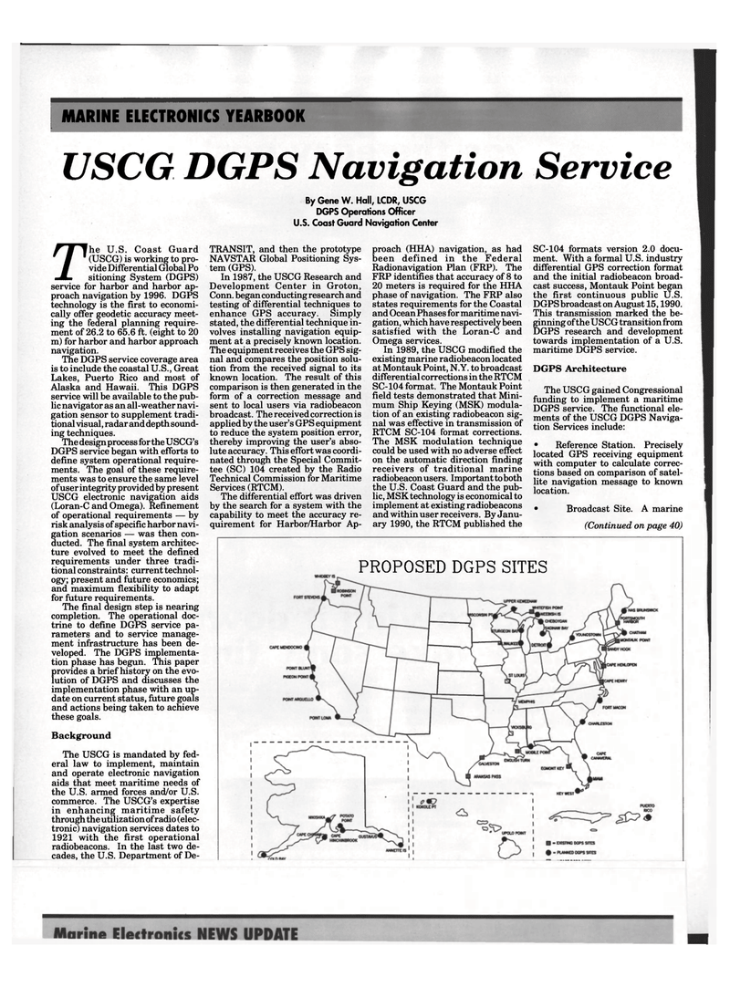
The DGPS service coverage area is to include the coastal U.S., Great
Lakes, Puerto Rico and most of
Alaska and Hawaii. This DGPS service will be available to the pub- lic navigator as an all-weather navi- gation sensor to supplement tradi- tional visual, radar and depth sound- ing techniques.
The design process for the USCG's
DGPS service began with efforts to define system operational require- ments. The goal of these require- ments was to ensure the same level of user integrity provided by present
USCG electronic navigation aids (Loran-C and Omega). Refinement of operational requirements — by risk analysis of specific harbor navi- gation scenarios — was then con- ducted. The final system architec- ture evolved to meet the defined requirements under three tradi- tional constraints: current technol- ogy; present and future economics; and maximum flexibility to adapt for future requirements.
The final design step is nearing completion. The operational doc- trine to define DGPS service pa- rameters and to service manage- ment infrastructure has been de- veloped. The DGPS implementa- tion phase has begun. This paper provides a brief history on the evo- lution of DGPS and discusses the implementation phase with an up- date on current status, future goals and actions being taken to achieve these goals.
Background
The USCG is mandated by fed- eral law to implement, maintain and operate electronic navigation aids that meet maritime needs of the U.S. armed forces and/or U.S. commerce. The USCG's expertise in enhancing maritime safety through the utilization of radio (elec- tronic) navigation services dates to 1921 with the first operational radiobeacons. In the last two de- cades, the U.S. Department of De-
TRANSIT, and then the prototype
NAVSTAR Global Positioning Sys- tem (GPS).
In 1987, the USCG Research and
Development Center in Groton,
Conn, began conducting research and testing of differential techniques to enhance GPS accuracy. Simply stated, the differential technique in- volves installing navigation equip- ment at a precisely known location.
The equipment receives the GPS sig- nal and compares the position solu- tion from the received signal to its known location. The result of this comparison is then generated in the form of a correction message and sent to local users via radiobeacon broadcast. The received correction is applied by the user's GPS equipment to reduce the system position error, thereby improving the user's abso- lute accuracy. This effort was coordi- nated through the Special Commit- tee (SC) 104 created by the Radio
Technical Commission for Maritime
Services (RTCM).
The differential effort was driven by the search for a system with the capability to meet the accuracy re- quirement for Harbor/Harbor Ap- proach (HHA) navigation, as had been defined in the Federal
Radionavigation Plan (FRP). The
FRP identifies that accuracy of 8 to 20 meters is required for the HHA phase of navigation. The FRP also states requirements for the Coastal and Ocean Phases for maritime navi- gation, which have respectively been satisfied with the Loran-C and
Omega services.
In 1989, the USCG modified the existing marine radiobeacon located at Montauk Point, N.Y. to broadcast differential corrections in the RTCM
SC-104 format. The Montauk Point field tests demonstrated that Mini- mum Ship Keying (MSK) modula- tion of an existing radiobeacon sig- nal was effective in transmission of
RTCM SC-104 format corrections.
The MSK modulation technique could be used with no adverse effect on the automatic direction finding receivers of traditional marine radiobeacon users. Important to both the U.S. Coast Guard and the pub- lic, MSK technology is economical to implement at existing radiobeacons and within user receivers. By Janu- ary 1990, the RTCM published the
SC-104 formats version 2.0 docu- ment. With a formal U.S. industry differential GPS correction format and the initial radiobeacon broad- cast success, Montauk Point began the first continuous public U.S.
DGPS broadcast on August 15,1990.
This transmission marked the be- ginning of the USCG transition from
DGPS research and development towards implementation of a U.S. maritime DGPS service.
DGPS Architecture
The USCG gained Congressional funding to implement a maritime
DGPS service. The functional ele- ments of the USCG DGPS Naviga- tion Services include: • Reference Station. Precisely located GPS receiving equipment with computer to calculate correc- tions based on comparison of satel- lite navigation message to known location. • Broadcast Site. A marine (Continued on page 40)
PROPOSED DGPS SITES
