
Page 36: of Maritime Reporter Magazine (June 1996)
Read this page in Pdf, Flash or Html5 edition of June 1996 Maritime Reporter Magazine
 35
35
 37
37
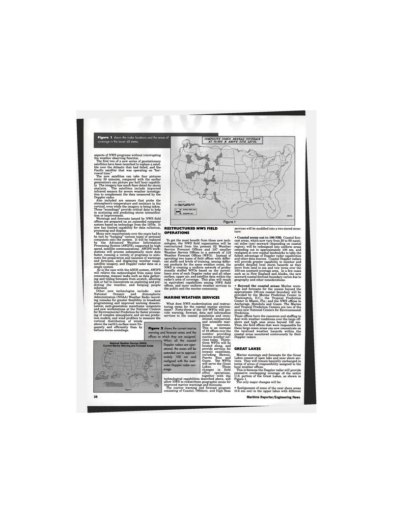
Figure 1 shows the radar locations and the areas of coverage in the lower 48 states.
COMPOSITE CONUS NEXRAD COVERAGE
AT 10,000 ft ABOVE SITE LEVEL aspects of NWS programs without interrupting the weather observing function.
The first two of a new series of geostationary satellites have been launched to replace a satel- lite over the Atlantic that had failed, and the
Pacific satellite that was operating on "bor- rowed time."
The new satellites can take four pictures every 30 minutes, compared with the earlier generation's one picture per half hour capabili- ty. The imagery has much finer detail for storm analysis. The satellites include improved infrared sensors for severe weather investiga- tion to complement the data measured by the
Doppler radar.
Also included are sensors that probe the atmosphere's temperature and moisture in the vertical, even while the imagery is being taken.
These "soundings" provide critical data to help in analyzing and predicting storm intensifica- tion or improvement.
Warnings and forecasts issued by NWS field offices are prepared on an outmoded computer system based on technology from the 1970s. It now has limited capability for data collection, processing and display.
Many new requirements over the years had to be met by "hanging" various types of personal computers onto the system. It will be replaced by the Advanced Weather Information
Processing System (AWIPS), supported by high speed, satellite communications. AWIPS work- stations will process substantially more data faster, running a variety of programs to auto- mate the preparation and issuance of warnings and forecasts, and displaying weather maps, satellite imagery, and Doppler radar data on a single system.
As is the case with the ASOS system, AWIPS will relieve the meteorologist from many time consuming, manual tasks such as data gather- ing and typing forecasts from scratch, allowing him or her to concentrate on analyzing and pre- dicting the weather, and keeping people informed.
Other new technologies include: new
National Oceanic and Atmospheric
Administration (NOAA) Weather Radio record- ing consoles for greater flexibility in broadcast programming and improved warning dissemi- nation; next-generation mainframe computers and new workstations at the National Centers for Environmental Prediction for faster process- ing of complex atmospheric and air-sea predic- tion models; and wind profilers to measure the vertical distribution of winds above the earth's surface more fre- quently and efficiently than by balloon-borne soundings.
AflEAS NOT CO«R£D BELOW
ICWOO f! ABOVE SHE 0 IOC NAUTICAL Mi£S (wnl)
M 0 185 KILOMETERS (ton)
Figure 1
National Weather Service (NWS)
Current Marine Warning and Forecast Areas
Figure 2
RESTRUCTURED NWS FIELD
OPERATIONS
To get the most benefit from these new tech- nologies, the NWS field organization will be restructured from the present 52 Weather
Service Forecast Offices and 197 smaller
Weather Service Offices to a network of 119
Weather Forecast Offices (WFO). Instead of operating two types of field offices with differ- ent staffs and levels of training, issuing differ- ent products for the same weather event, the
NWS is creating a uniform network of profes- sionally staffed WFOs based on the surveil- lance area of each Doppler radar and all other surface, upper air, and satellite data within the radar's area of coverage. This plan will result in equivalent capabilities among NWS field offices, and more uniform weather services to the public and the marine community.
MARINE WEATHER SERVICES
What does NWS modernization and restruc- turing mean for the coastal marine environ- ment? Forty-three of the 119 WFOs will pro- vide warning, forecast, data and information services to the coastal population and recre- ational, commercial, and scientific mar- itime interests.
This is an increase of 19 offices over the number providing marine weather ser- vices today. Thirty- three WFOs will be located along, and provide services for oceanic coastlines, including Hawaii,
Puerto Rico and
Guam. Ten WFOs will serve the Great
Lakes. These changes in field office operations, together with the
Figure 2 shows the current marine warning and forecast areas and the offices to which they are assigned.
When all the coastal
Doppler radars are oper- ational, the areas will be extended out to approxi- mately 100 nm and realigned with the over- water Doppler radar cov- erage. technological capabilities described above, will allow NWS to redistribute geographic areas for improved marine warnings and forecasts.
The marine warning and forecast program consisting of Coastal, Offshore, and High Seas services will be modified into a two-tiered struc- ture: • Coastal areas out to 100 NM: Coastal fore- cast areas, which now vary from 20 to 60 nauti- cal miles (nm) seaward (depending on coastal region), will be redesigned into uniform areas extending out to approximately 100 nm, and realigned at new coastal landmarks to take the fullest advantage of Doppler radar capabilities and other data sources. Coastal Doppler radars will provide greater capability to monitor and predict detailed local storm hazards as they move from land to sea and vice versa over the 100-nm seaward coverage area. In a few cases such as in New England and Alaska, the new seaward coastal forecast boundary varies due to geography and other considerations. • Beyond the coastal areas: Marine warn- ings and forecasts for the oceans beyond the approximate 100-nm coastal boundary will be provided by the Marine Prediction Center in
Washington, D.C.; the Tropical Prediction
Center in Miami, Fla.; and the NWS offices in
Anchorage, Honolulu and Guam. The Marine and Tropical Prediction Centers are two of the seven new National Centers for Environmental
Prediction.
These offices have the resources and staffing to deal with weather conditions over the large off- shore and high seas areas beyond 100 nm.
Thus, the field offices that were responsible for these large ocean areas can now concentrate on the localized weather hazards within the coastal areas monitored continuously by their
Doppler radars.
GREAT LAKES
Marine warnings and forecasts for the Great
Lakes consist of open lake and near shore ser- vices. They will remain basically unchanged in terms of areas of responsibility assigned to the local weather offices.
This is because the Doppler radar will provide extensive overlapping coverage of the entire
U.S. portion of the Great Lakes, as shown in
Figure 1.
The only major changes will be: • Realignment of some of the near shore areas (0-5 nm out) in the upper lakes with different 38 Maritime Reporter/Engineering News
