
Page 38: of Maritime Reporter Magazine (June 1996)
Read this page in Pdf, Flash or Html5 edition of June 1996 Maritime Reporter Magazine
 37
37
 39
39
coastal landmarks as the individual Doppler radars become operational. • Transfer of responsibility for Lake Superior warnings and forecasts from the Romeoville, 111., office to the future WFO in Marquette,
Mich., after the AWIPS computer system becomes operational.
COOPERATION WITH THE
PRIVATE SECTOR
The NWS marine warnings and forecasts are general products designed to provide basic information on winds, waves, weather, ice, and visibility as they affect safety of life and prop- erty at sea. These marine products and ser- vices are developed and refined from a broad consensus of requirements put forth by all sec- tors of the maritime community.
Specialized marine weather analyses, fore- casts, data sets, and packaged information to meet specific requirements of individual mar- itime users or segments of the community are the responsibility of the private weather infor- mation industry. For example, the NWS will not issue forecasts of wind or wave conditions for specific locations and times upon request of a marine user requiring such services. It is the strict policy of the NWS to refer all such requests for specialized or tailored services to the private sector.
To assist the private sector in providing spe- cialized products and services and to promote the economic viability of the industry, the NWS provides subscriber access to the Family of
Services computer system for receipt of a whole range of data and products. The NWS encour- ages users to take advantage of these special- ized services offered by the private weather information industry in the hope that access to a combination of NWS and private sector weather products will provide the user with the most complete and comprehensive weather information to enhance maritime safety and productivity.
The Doppler radar and the other new observ- ing technologies are proving to be valuable tools for predicting severe weather conditions that impact marine safety ranging from localized severe thunderstorms and squalls, to major ocean storms. Installation of AWIPS systems is scheduled to begin in 1997, soon after comple- tion of the coastal Doppler radar network. A more streamlined field office structure, staffed with highly trained meteorologists and sup- ported by improved National Center guidance, will allow NWS to derive maximum benefit from the technological advances. The growing partnership between NWS and the private weather informa- tion
National Weather Service (NWS)
Stage 1 Marine Warning and Forecast Areas will • NWS locations
Coastal Warning/Forecast Area
Outto Approximately 100om
Local Warning Areas
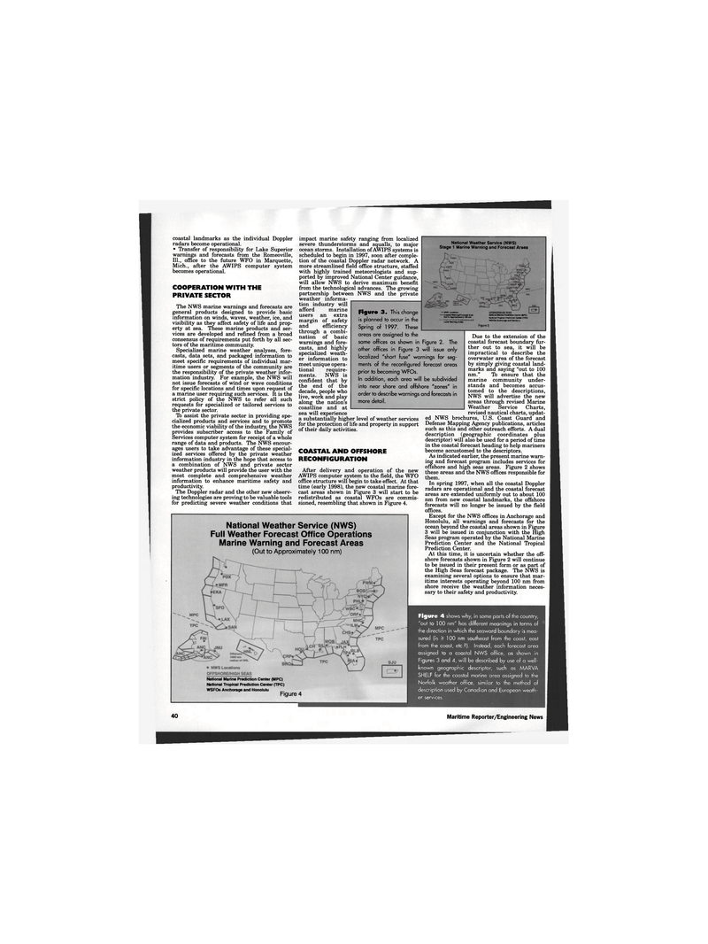
Figure 3. This change is planned to occur in the
Spring of 1997. These areas are assigned to the same offices as shown in Figure 2. The other offices in Figure 3 will issue only localized "short fuse" warnings for seg- ments of the reconfigured forecast areas prior to becoming WFOs.
In addition, each area will be subdivided into near shore and offshore "zones" in order to describe warnings and forecasts in more detail. industry afford marine users an extra margin of safety and efficiency through a combi- nation of basic warnings and fore- casts, and highly specialized weath- er information to meet unique opera- tional require- ments. NWS is confident that by the end of the decade, people who live, work and play along the nation's coastline and at sea will experience a substantially higher level of weather services for the protection of life and property in support of their daily activities.
COASTAL AND OFFSHORE
RECONFIGURATION
After delivery and operation of the new
AWIPS computer system to the field, the WFO office structure will begin to take effect. At that time (early 1998), the new coastal marine fore- cast areas shown in Figure 3 will start to be redistributed as coastal WFOs are commis- sioned, resembling that shown in Figure 4.
OFFSHORE/HIGH SEAS
National Marine Prediction Center {MPC)
National Tropical Prediction Center (TPC)
WSFOs Anchorage and Honolulu
C3>
Figure 3
National Weather Service (NWS)
Full Weather Forecast Office Operations
Marine Warning and Forecast Areas (Out to Approximately 100 nm)
Due to the extension of the coastal forecast boundary fur- ther out to sea, it will be impractical to describe the overwater area of the forecast by simply giving coastal land- marks and saying "out to 100 nm." To ensure that the marine community under- stands and becomes accus- tomed to the descriptions,
NWS will advertise the new areas through revised Marine
Weather Service Charts, revised nautical charts, updat- ed NWS brochures, U.S. Coast Guard and
Defense Mapping Agency publications, articles such as this and other outreach efforts. A dual description (geographic coordinates plus descriptor) will also be used for a period of time in the coastal forecast heading to help mariners become accustomed to the descriptors.
As indicated earlier, the present marine warn- ing and forecast program includes services for offshore and high seas areas. Figure 2 shows these areas and the NWS offices responsible for them.
In spring 1997, when all the coastal Doppler radars are operational and the coastal forecast areas are extended uniformly out to about 100 nm from new coastal landmarks, the offshore forecasts will no longer be issued by the field offices.
Except for the NWS offices in Anchorage and
Honolulu, all warnings and forecasts for the ocean beyond the coastal areas shown in Figure 3 will be issued in conjunction with the High
Seas program operated by the National Marine
Prediction Center and the National Tropical
Prediction Center.
At this time, it is uncertain whether the off- shore forecasts shown in Figure 2 will continue to be issued in their present form or as part of the High Seas forecast package. The NWS is examining several options to ensure that mar- itime interests operating beyond 100 nm from shore receive the weather information neces- sary to their safety and productivity.
National Marine Prediction Center (MPC)
National Tropical Prediction Center (TPC)
WSFOs Anchorage and Honolulu Figure 4
Figure 4 shows why, in some parts of the country, "out to 100 nm" has different meanings in terms of the direction in which the seaward boundary is mea- sured (is it 100 nm southeast from the coast, east from the coast, etc.?). Instead, each forecast area assigned to a coastal NWS office, as shown in
Figures 3 and 4, will be described by use of a well- known geographic descriptor, such as MARVA
SHELF for the coastal marine area assigned to the
Norfolk weather office, similar to the method of description used by Canadian and European weath- er services. 40 Maritime Reporter/Engineering News
