Page 30: of Maritime Reporter Magazine (November 1997)
Read this page in Pdf, Flash or Html5 edition of November 1997 Maritime Reporter Magazine
 29
29
 31
31
Raster V. Vector — the battle continues
The relentless advance of new technology continues to force change in one of the world's oldest and most conservative of activi- ties, the marine industry.
Navigation at sea has been developed over thousands of years. Probably — until recent times — its most important advance was the chronometer making possible the calculation of longitude. But even this momen- tous event is being overshadowed by the development of electronic navigation concepts. Not least among these is ECDIS — elec- tronic chart display and informa- tion systems.
There are currently two types of accepted electronic charting systems. Raster and Vector.
Raster charts are more easily pro- duced than those using the vector- ized principle, which involves pro- ducing data in layers laid progres- sively on top of each other.
One of the major advocates of raster charts is the U.K.
Hydrographic Office (UKHO), whose systems can transpose its paper chart portfolios to raster scan products, capable of being used by approved electronic chart systems under its ARCS service.
This has initially provided the marine industry with an accept- able electronically digitized for- mat, but lacks the versatility of the vectorized chart.
The U.K. Hydrographic Office (UKHO) said that it does not take a position favoring raster or vec- tor charts — providing they are officially authorized — but sees great benefit from combining the two systems for a complete, world- wide coverage.
The compilation of a vectorized chart is a time-consuming and lengthy process and production is being concentrated on high-risk areas such as coasts and harbors, leaving the deep sea and ocean passage routes to be covered by
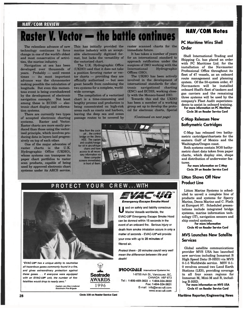
View from the cock- pit .. the control bridge on the Stena
HSS. The captain and co-pilot/naviga- tor sit in aircraft-type chairs and have access to all neces- sary information via three computer screens immediately in front of them. raster scanned charts for the immediate future.
It has taken a number of years for an international standard to approach ratification under the auspices of IMO working with the
International Hydrographic
Offices (IHO).
The UKHO has been actively involved in the development of international standards for elec- tronic navigational charting (ENC) and ECDIS, working close- ly with the Monaco-based IHO.
Towards this end the UKHO has been a member of a working group set up to develop the proto- col for electronic charts, Special (Continued on next page)
PROTECT YOUR CREW...WITH "EVAC-U8® has a unique ability to neutralise all hazardous gases commonly found in a fire, and gives extraordinary protection against these gases. . . If everyone were equipped with an EVAC-U8® unit, the number of fire- fatalities would drop to nearly zero."
Captain Jan-Olav Lindkvist
Stockholm Fire Brigade
Seatrade
AWARDS 1996 'flyrdjf
Emergency Escape Smoke Hood
Used on safety and liability conscious Marine Vessels worldwide, the
EVAC-U8® Emergency Escape Smoke Hood can be donned within 15 seconds in the event of an onboard fire. Serious injury or death from smoke inhalation occurs in only a matter of seconds - EVAC-U8®will provide your crew with up to 20 minutes of filtered air.
Protect them - 20 minutes could very well mean the difference between life and death! 3SOOCDALE International Systems Inc. 1-8755 Ash St., Vancouver, BC,
CANADA V6P6T3
Tel: 1-800-459-3822 • 1-604-324-3822
Fax: 1-604-324-3821
E-mail: [email protected] _ www.evac-u8.com . 28 Circle 339 on Reader Service Card
NAV/COM Notes
PC Maritime Wins Shell
Order
Shell International Trading and
Shipping Co. has placed an order with PC Maritime Ltd. for the installation of the Navmaster
Professional Office throughout its fleet of 47 vessels, as an onboard route management and planning system. Of the 50-system order, 47
Navmasters will be installed onboard Shell's fleet of tankers and gas carriers and the remaining three systems will be used by the company's Fleet Audit superinten- dents to assist in onboard training.
For more information on PC Maritime
Circle 38 on Reader Service Card
C-Map Releases New
Bathymetric Cartridges
C-Map has released two bathy- metric cartridges/chartsets for the eastern Gulf of Mexico and the
Washington/Oregon coast.
Both systems contain NOS bathy- metric chart data taken from paper charts, which display size, shape and distribution of underwater fea- tures.
For more information on C-Map
Circle 39 on Reader Service Card
Litton Shows Off New
Product Line
Litton Marine Systems is sched- uled to unveil a complete line of products and systems for Sperry
Marine, Decca Marine and C. Plath at Europort 97. Scheduled presen- tations include integrated bridge systems, marine information tech- nology (IT), navigation sensors and ship control systems.
For more information
Circle 40 on Reader Service Card
MVS Launches New Satellite
Services
Global satellite communications provider MVS USA has launched new services including Inmarsat B
High Speed Data (B-HSD) via MVS 0-1-5 Worldwide service. MSV 0-1- 0 revolves around two Land Earth
Stations (LES), providing coverage in all four ocean regions for
Inmarsat M, Mini-M and B, includ- ing B-HSD.
For more information on MVS USA
Circle 41 on Reader Service Card
Maritime Reporter/Engineering News
