Page 52: of Maritime Reporter Magazine (August 2001)
Read this page in Pdf, Flash or Html5 edition of August 2001 Maritime Reporter Magazine
 51
51
 53
53
Marine Electronics: Charts
Chartco: The Best of Both Worlds
Created just three years ago, Chartco embraces a small company's flexibility and innovative attitude but is supported by a big company bankroll. Dr. Andy
Norris, Chartco's managing director, recently spent some time with MR/EN to discuss the present and future of electronic charts.
The realization of electronic charts replacing their paper brethren has been slow in coming, to say the least. For a number of technical, political and eco- nomic reasons, the fight to develop and implement a universally acceptable solution and standard has yet to be accomplished. This is not to say, though, that tremendous strides have not been taken, as the quanti- ty and quality of electronic charting products and sys- tems has grown exponentially in recent years.
Despite the numerous stops and starts, Dr. Andy
Norris, managing director of the dynamic U.K.-based company Chartco, believes that the tide is surely turn- ing and acceptance of the new technology is now, as the technical specifications are done and type approval for the equipment is imminent. In fact, Norris predicts that between 2002 and 2005 there will be a big push towards electronic charts, and that by 2007 electronic charts will have displaced paper charts in terms of maket share.
Chartco is a global broadcaster of marine informa- tion via satellite, launched in 1998 to broadcast updates for paper navigation charts to ships using the Inmarsat satellite Point to Multi-Point service. The company is small by many accounts, yet it is jointly owned by two corporate heavyweights; Smiths Group (which also owns Kelvin Hughes) owns 60 percent and Fugro owns 40 percent. At the helm, Norris delivers a careers of technology expertise, including eight years as the technical director of Kelvin Hughes.
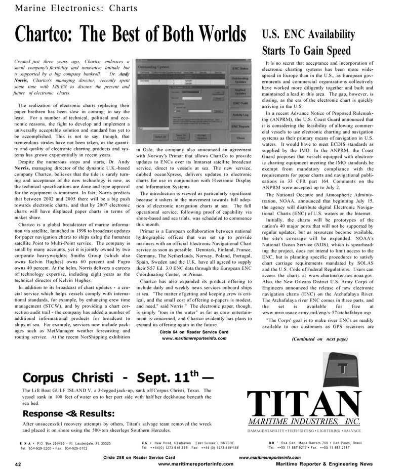
In addition to its broadcast of chart updates - a cru- cial service which helps vessels comply with interna- tional standards, for example, by enhancing crew time management (STCW), and by providing a chart cor- rection audit trail - the company has added a number of additional informational products for broadcast to ships at sea. For example, services now include pack- ages such as MetManager weather forecasting and routing service. At the recent NorShipping exhibition in Oslo, the company also announced an agreement with Norway's Primar that allows ChartCo to provide updates to ENCs over its Inmarsat satellite broadcast service, direct to vessels at sea. The new service, dubbed oceanXpress, delivers updates to electronic charts for use in conjunction with Electronic Display and Information Systems.
The introduction is viewed as particularly significant because it ushers in the movement towards full adop- tion of electronic navigation charts at sea. The full operational service, following proof of capability via shore-based and sea trials, was scheduled to commence this month.
Primar is a European collaboration between national hydrographic offices that was set up to provide mariners with an official Electronic Navigational Chart service as sson as possible. Denmark, Finland, France,
Germany, The Netherlands, Norway, Poland, Portugal,
Spain, Sweden and the U.K. have all agreed to supply their S57 Ed. 3.0 ENC data through the European ENC
Coordinating Center, or Primar.
Chartco has also expanded its product offering to include daily and weekly news services onboard ships at sea. "The matter of getting and keeping crew is crit- ical, and the small cost of offering e-papers is modest, and need," said Norris." The electronic paper, though, is simply "toes in the water" as far as crew entertain- ment is concerned, and Chartco evidently has plans to expand its offering again in the future.
Circle 54 on Reader Service Card www. maritimereporterinfo. com
U.S. ENC Availability
Starts To Gain Speed
It is no secret that acceptance and incorporation of electronic charting systems has been more wide- spread in Europe than in the U.S., as European gov- ernments and commercial organizations collectively have worked more diligently together and built and maintained a lead in this area. The gap, however, is closing, as the era of the electronic chart is quickly arriving in the U.S.
In a recent Advance Notice of Proposed Rulemak- ing (ANPRM), the U.S. Coast Guard announced that it is considering the feasibility of allowing commer- cial vessels to use electronic charting and navigation systems as their primary means of navigation in U.S. waters. It would have to meet ECDIS standards as supplied by the IMO. In the ANPRM, the Coast
Guard proposes that vessels equipped with electron- ic charting equipment meeting the IMO standards be exempt from mandatory compliance with the requirements for paper charts and navigational publi- cations in 33 CFR part 164. Comments on the
ANPRM were accepted up to July 2.
The National Oceanic and Atmospheric Adminis- tration, NOAA, announced that beginning July 15, the agency will distribute digital Electronic Naviga- tional Charts (ENC) of U.S. waters on the Internet.
Initially, the charts will be prototypes of the nation's 40 major ports that will not be supported by regular updates, but as resources become available, the site's coverage will be expanded. NOAA's
National Ocean Service (NOS), which is spearhead- ing the project, does not intend to limit access to the
ENC, but is planning specific procedures to satisfy chart carriage requirements mandated by SOLAS and the U.S. Code of Federal Regulations. Users can access the charts at www.chartmaker.nos.noaa.gov.
Also, the New Orleans District U.S. Army Corps of
Engineers announced the release of new electronic navigation charts (ENC) on the Atchafalaya River.
The Atchafalaya river ENC comes in three parts, and the set is available for free at www.mvn.usace.army.mil/eng/s-57/atchafalaya.asp "The Corps' goal is to make river ENCs as readily available to our customers as GPS receivers are (Continued on next page)
Corpus Christi - Sept. 11th —
The Lift Boat GULF ISLAND V, a 3-legged jack-up, sank off Corpus Christi, Texas. The vessel sank in 100 feet of water on to her port side with half her deckhouse beneath the sea bed.
Response <& Results:
After unsuccessful recovery attempts by others, Titan's salvage team removed the wreck and placed it on shore using the 500-ton sheerlegs Southern Hercules.
USA • P.O. Box 350465 • Ft. Lauderdale, FL 33335
Tel: 954-929-5200 • Fax: 954-929-0102
UK • New Road, Newhaven East Sussex • BN90HE
Tel: ++44(0) 1273 515-555 Fax: ++44 (0) 1273 515^156
TITAN
MARITIME INDUSTRIES, INC.
DAMAGE STABILITY • FIREFIGHTING • LIGHTERING • SALVAGE
BR ' Rua Gen. Mena Barreto 708 • Sao Paulo, Brasil
Tel: ++55 11 887 9217 • Fax: ++55 11 887 2687 42
Circle 286 on Reader Service Card www.maritimereporterinfo.com www.maritimereporterinfo.com Maritime Reporter & Engineering News
