
Page 28: of Maritime Reporter Magazine (June 2012)
Annual World Yearbook
Read this page in Pdf, Flash or Html5 edition of June 2012 Maritime Reporter Magazine
 27
27
 29
29
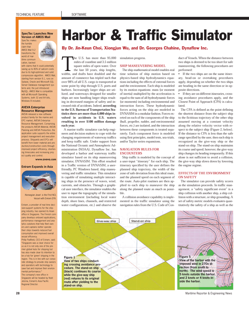
28Maritime Reporter & Engineering News The U.S. has more than 95,000miles of coastline and 3.5 millionsquare miles of open water. Over the last 50 years, ship lengths,widths, and drafts have doubled and the amount of commerce has tripled such thatover 98% of all U.S. cargo is transported at some point by ship through U.S. ports andharbors. Increasingly larger ships are uti- lized, and waterways designed for smaller ships are now handling larger ships result- ing in decreased margins of safety and in- creased risk of accidents. Indeed, accordingto the U.S. Bureau of Transportation Sta- tistics there are more than 6,000 ships in- volved in accidents in U.S. waters resulting in over $100 million damage each year. A marine traffic simulator can help engi- neers and decision makers to cope with the changing requirements of waterway traffics and keep traffic safe. Under support from the National Oceanic and Atmospheric Ad- ministration (NOAA), Dynaflow Inc. has developed a harbor and waterway traffic simulator based on its ship maneuvering simulator, DYNASIM. This effort resulted in a Traffic version of DYNASIM, a user- friendly, PC Windows based, ship maneu- vering and traffic simulator. This simulator is capable of simulating multiple interact- ing ships in the presence of waves, wind, currents, and obstacles. Through a graphi- cal user interface, the simulator enables the user to input the topography of the simula- tion environment (including local water depth, shore lines, channels, and restrictedwater configurations, etc.) and observe the simulation progress. SHIP MANEUVERING MODELThe ship mathematical model enables realtime solution of ship motion based onphysics-based ship hydrodynamics equa- tions including the effects of external forces and the environment. Each ship is modeled by its motion equations: mass (or momentof inertia) multiplied by the acceleration isequal to the sum of all hydrodynamic forces (or moments) including environmental and interaction forces. These hydrodynamic forces acting on the ship are modeled inDYNASIM in a modular fashion. Forces ex- erted on each of the components of the ship(hull, propeller, rudder, and environmental forces, etc.) are isolated, and the interactionbetween these components is treated sepa-rately. Each component force is modeled using first principles, model tests, sea-trials, and/or Taylor series expansions. NAVIGATION RULES FOR ENCOUNTERSShip traffic is modeled by the concept of a user-input ?itinerary? for each ship. The itinerary specified by the user defines the planned ship trajectory, the width of the zone of safe deviation from this ideal route, and the planned speed on each segment of the route. Auto-pilot routines are then ap- plied to each ship to maneuver the ship along the planned route as much as possi-ble. A collision avoidance capability is imple- mented in the traffic simulator using the navigation rules from the U.S. Code of Con- duct of Vessels. When the distance between two ships is deemed to be too short for safe maneuvering, the following procedures are performed: If the two ships are on the same itiner- ary, head-on or overtaking procedures apply, depending on whether the two ships are heading in the same direction or in op-posite directions. If they are on different itineraries, cross- ing avoidance procedures apply, and the Closest Point of Approach (CPA) is calcu- lated. The CPA is defined as the point defining the shortest distance from the subject shipto the fictitious trajectory of the other ship assumed moving at a constant velocity along the relative velocity vector with re- spect to the subject ship (Figure 2, below). If the distance to CPA is less than the safe range specified by the user, then each ship is recognized as the give-way ship or the stand-on ship. The stand-on ship maintains its course and speed; however, the give-way ship changes its heading temporarily. If this alone is not sufficient to avoid a collision, the give-way ship slows down by lowering the engine regime. EFFECTS OF THE ENVIRONMENT ON SAFETYThe simulator can provide safety scores as the simulation proceeds. In traffic man- agement, a ?safety significant event? is a ship collision with another ship, a ship col-lision with a structure, or ship grounding. A set of safety metric models evaluates quan- titatively the safety of a ship as well as the TECHNICAL FEATURE SOFTWAREHarbor & Traffic Simulator By Dr. Jin-Keun Choi, Xiongjun Wu, and Dr. Georges Chahine, Dynaflow Inc. SpecTec Launches New Version of AMOS Mail SpecTec makes the humbleclaim thatAMOS Mail 9.2transforms theworld of mar-itime communi-cation, backedwith claims that it could potentiallysaving up to 80% of satcom costsdue to its high-optimized and solidcompression algorithm. AMOS Mail, starting from version 9.1, runs on Sybase, Oracle and Microsoft SQL Server Database management sys-tems and, the just introduced MySQL. AMOS Mail is compatiblewith all Microsoft Operating Systems, both 32 and 64 bits,Windows 8 included. AVEVA Enterprise Resource Management AVEVA released a new software product family for the marine and EPC market, AVEVA Enterprise Resource Management. Comprising the products AVEVA Material, AVEVA Planning and AVEVA Production, the application suite supports the entire project management and execution process. Shipyards and EPCs will benefit from lower material and pro- duction/construction costs through improved project efficiency, shorten- ing timescales and increasing proj- ect quality and control. www.aveva.com Eniram Expands in AsiaNorwegian Jewel is the First NCLVessel with Eniram DTA. Eniram, a provider of real time deci- sion-support systems for the ship- ping industry, has opened its Asian office in Singapore. The Finnish com- pany develops onboard applications, performance management and ana- lytics solutions that help fleet own-ers and captains better operatetheir ships towards reduced fuel consumption and improved overall vessel efficiency. Philip Padfield, CEO of Eniram, said:?Singapore was a clear choice for us as it is not only one of the pre- mier global hubs for shipping buthas also made clear its intention tobe a hub for ?green? shipping in the region. This is in line with our corpo- rate strategy to provide ship owners and operators with technology tosave fuel and improve their environ- mental performance.? The company?s new office in Singapore will be headed by Noël Jelsma, Eniram?s Asia Pacific Regional Director. Figure 1 View of two ships conduct- ing crossing avoidance pro- cedure. The stand-on ship (black) continues its coursewhile the give-way ship(red) returns to its original route after yielding to the stand-on ship.Figure 5 View of the harbor with the imposed wind in 270o di-rection (from south to north). The wind speed is 5 knots outside the harbor, and 2 knots or 4 knots in-side the harbor. MR June12 # 4 (25-33):MR Template 6/11/2012 4:12 PM Page 28
