Page 62: of Maritime Reporter Magazine (November 2013)
Marine Propulsion Annual
Read this page in Pdf, Flash or Html5 edition of November 2013 Maritime Reporter Magazine
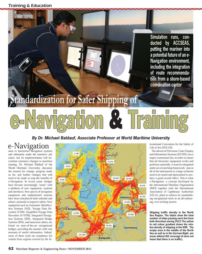
62 Maritime Reporter & Engineering News ? NOVEMBER 2013 Training & Educatione-Navigation aims to harmonize navigation systems and ultimately make the mariners? job easier, but its implementation will ne- cessitate extensive changes to maritime training. Dr. Michael Baldauf of the World Maritime University, discusses the reasons for change, progress made so far, and further changes that will need to be made to reap the beneÞ ts of e-Navigation. In recent years, bridges have become increasingly ?smart? with a plethora of new equipment, systems and interfaces. New pieces of navigation equipment and sophisticated systems have been introduced both onboard and ashore, primarily to improve safety. New equipment such as Automatic Identi Þ ca-tion Systems (AIS), Voyage Data Re- corders (VDR), SimpliÞ ed Voyage Data Recorders (S-VDR), Integrated Naviga-tion Systems (INS), Integrated Bridge Systems (IBS), and numerous others, are found on state-of-the-art navigational bridges, providing the mariner with vast amounts of useful information. Indeed, some of these tools are mandatory for vessels from regions covered by the In-ternational Convention for the Safety of Life at Sea (SOLAS). The advent of Electronic Chart Display and Information Systems (ECDIS) was a major cornerstone but, in order to ensure that all electronic equipment works and performs optimally, it must be integrated under an overarching framework - just as all of the instruments in a large orchestra need to be tuned and harmonised to pro-duce a good overall effect. This is what e-Navigation, a concept developed by the International Maritime Organisation (IMO) together with the International Association of Lighthouse Authorities (IALA), plans to achieve by standardis-ing navigational tools in an all-embrac-ing, over-arching system. e-Navigation & Training Standardization for Safer Shipping of By Dr. Michael Baldauf, Associate Professor at World Maritime University Simulation runs, con-ducted by ACCSEAS, putting the mariner into a potential future of an e- Navigation environment, including the integration of route recommenda- tion from a shore-based coordination center Shipping trafÞ c density in the North Sea Region. The labels show the total number of ships passing each line from both directions during 2012.The yellow to red colour gradient shows the rela- tive density of shipping in the NSR. The empty area in the middle of the North Sea as well as in the German Bight, are areas without AIS coverage (it does not mean that there is no trafÞ c).MR #11 (58-65).indd 62MR #11 (58-65).indd 6211/11/2013 12:16:18 PM11/11/2013 12:16:18 PM

 61
61

 63
63
