
Page 30: of Maritime Reporter Magazine (April 2014)
Offshore Edition
Read this page in Pdf, Flash or Html5 edition of April 2014 Maritime Reporter Magazine
 29
29
 31
31
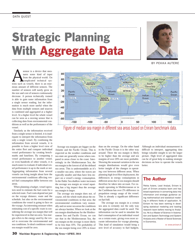
30 Maritime Reporter & Engineering News ? APRIL 2014 DATA QUEST A sensor is a device that mea-sures some kind of input from the physical world. On complicated technical sys-tems such as vessels, there is an enor- mous amount of different sensors. The number of sensors will surely grow as the size and cost of sensors continuously decrease. A person technically trained is able to gain some information from a single sensor reading, but the infor- mation is much more useful when the data from multiple sensors and sources is combined and aggregated at a higher level. At a higher level the whole vessel can be seen as a moving sensor that is collecting data from environmental con-ditions as well as the performance of the vessel.Similarly as the information received from a single sensor is limited, it is inad-equate to interpret the information from only a single vessel. By combining the information from several vessels, it is possible to form a higher level view of the entire ß eet and compare individual vessel performance by creating bench-marks and baselines. By comparing a vessel performance to another vessel, or even hundreds of other vessels, it is much easier to evaluate if individual ves-sel performance is up to the mark or not. Aggregating information from several vessels can bring insight about how the environmental conditions affecting ves- sel fuel consumption differ between sea areas.When planning a budget, vessel opera-tors need to estimate the fuel costs for a selected route. Fuel costs depend not just on the voyage distance, route and the schedule, but also on the environmental conditions the vessel is going to face on the voyage. An interesting measure when estimating cost of a speciÞ c route is con- sidering the average sea margin that will be experienced in that sea area. Sea mar- gin refers to the energy used by the ves- sel to overcome the environmental and sea conditions. In ideal conditions vessel sea margin would be zero. Average sea margins are bigger on the Atlantic and the PaciÞ c Ocean. This is expected as the weather conditions and sea state are generally worse when com-pared to areas closer to the coast. Inter- estingly in the Mediterranean Sea, the sea margin is the lowest of all the de Þ ned sea areas. This is understandable as it?s a smaller sea area, where the waves are typically smaller and thus have less im-pact on a vessel?s energy consumption. In the Baltic Sea shallow water increases the average sea margin as vessel squat- ting has a big impact thus the average sea margin is larger. The average sea margin does not, of course, tell the whole truth about the en-vironmental conditions in that area; the environmental conditions vary season-ally and on some sea areas the conditions are always harsher. When we look at the sea margin distributions for the Mediter- ranean Sea and PaciÞ c Ocean, we can see that in the Mediterranean Sea, the sea margin on the average is more likely to be less than 10%. The probability of the sea margin being over 20% is lesser than on the average. On the other hand in the PaciÞ c Ocean it is the other way around. There the sea margin is likely to be higher than the average and sea margins of over 20% are more probable. Showing the seasonal variation in the sea margin distributions would give even better insight of the changes in operat-ing cost between different areas. When planning high level ß eet deployment, the differences in energy consumptions in different areas due to sea margins should therefore be taken into account. For ex-ample operating in Mediterranean or in the Caribbean has over 2% difference in propulsion energy usage of the vessel. This is already a signiÞ cant difference on fuel bill. The average sea margin in a certain sea area is certainly not the only way the aggregated data could be used. The information can be used to simulate the fuel consumption of an individual vessel on a certain route, giving even more ac-curate information for voyage planning. This kind of simulation would bring a new level of accuracy to fuel budgets. Although an individual measurement is difÞ cult to interpret, aggregating data brings valuable insight to see the larger picture. High level of aggregated data can be of great help in making strategic decisions on how to operate the vessels better. Strategic Planning With Aggregate Data BY PEKKA AUTERE Figure of median sea margin in different sea areas based on Eniram benchmark data. The AuthorPekka Autere, Lead Analyst, Eniram is part of Eniram analytics team and has broad experience in converting data into information and strategic guidance us- ing mathematical and statistical model-ing in different Þ elds of application. At Eniram he has been working in devel- oping statistical modeling and leading research team before moving to Analyt- ics. He is a Master of Science in Automa- tion and System Technology and System Analysis and a Master of Social Sciences in Economics. w: www.eniram. Þ MR #4 (26-33).indd 30MR #4 (26-33).indd 304/4/2014 10:51:34 AM4/4/2014 10:51:34 AM
