
Page 20: of Maritime Reporter Magazine (May 2016)
The Marine Propulsion Edition
Read this page in Pdf, Flash or Html5 edition of May 2016 Maritime Reporter Magazine
 19
19
 21
21
GOVERNMENT UPDATE
Automated Skill Erosion
The increasing automation of vessels is causing some mariners to lose basic maritime skills.
DENNIS BRYANT
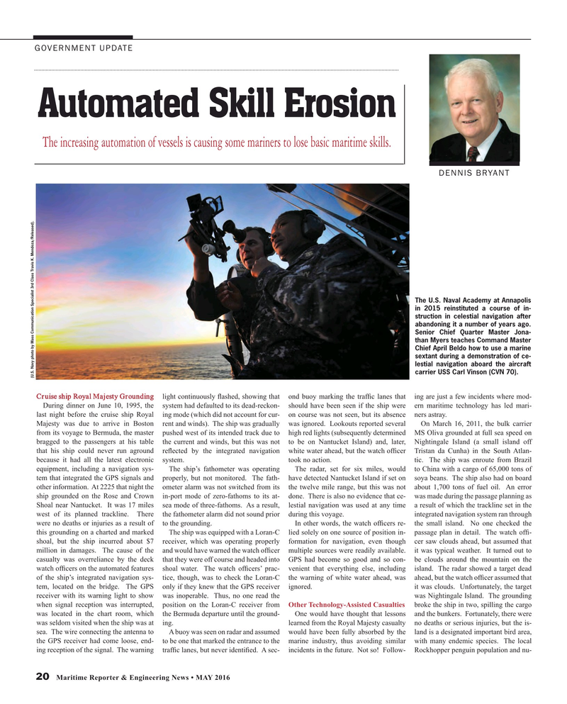
The U.S. Naval Academy at Annapolis in 2015 reinstituted a course of in- struction in celestial navigation after abandoning it a number of years ago.
Senior Chief Quarter Master Jona- than Myers teaches Command Master
Chief April Beldo how to use a marine sextant during a demonstration of ce- lestial navigation aboard the aircraft carrier USS Carl Vinson (CVN 70).
(U.S. Navy photo by Mass Communication Specialist 3rd Class Travis K. Mendoza/Released).
Cruise ship Royal Majesty Grounding light continuously ? ashed, showing that ond buoy marking the traf? c lanes that ing are just a few incidents where mod-
During dinner on June 10, 1995, the system had defaulted to its dead-reckon- should have been seen if the ship were ern maritime technology has led mari- last night before the cruise ship Royal ing mode (which did not account for cur- on course was not seen, but its absence ners astray.
Majesty was due to arrive in Boston rent and winds). The ship was gradually was ignored. Lookouts reported several On March 16, 2011, the bulk carrier from its voyage to Bermuda, the master pushed west of its intended track due to high red lights (subsequently determined MS Oliva grounded at full sea speed on bragged to the passengers at his table the current and winds, but this was not to be on Nantucket Island) and, later, Nightingale Island (a small island off that his ship could never run aground re? ected by the integrated navigation white water ahead, but the watch of? cer Tristan da Cunha) in the South Atlan- because it had all the latest electronic system. took no action. tic. The ship was enroute from Brazil equipment, including a navigation sys- The ship’s fathometer was operating The radar, set for six miles, would to China with a cargo of 65,000 tons of tem that integrated the GPS signals and properly, but not monitored. The fath- have detected Nantucket Island if set on soya beans. The ship also had on board other information. At 2225 that night the ometer alarm was not switched from its the twelve mile range, but this was not about 1,700 tons of fuel oil. An error ship grounded on the Rose and Crown in-port mode of zero-fathoms to its at- done. There is also no evidence that ce- was made during the passage planning as
Shoal near Nantucket. It was 17 miles sea mode of three-fathoms. As a result, lestial navigation was used at any time a result of which the trackline set in the west of its planned trackline. There the fathometer alarm did not sound prior during this voyage. integrated navigation system ran through were no deaths or injuries as a result of to the grounding. In other words, the watch of? cers re- the small island. No one checked the this grounding on a charted and marked The ship was equipped with a Loran-C lied solely on one source of position in- passage plan in detail. The watch of? - shoal, but the ship incurred about $7 receiver, which was operating properly formation for navigation, even though cer saw clouds ahead, but assumed that million in damages. The cause of the and would have warned the watch of? cer multiple sources were readily available. it was typical weather. It turned out to casualty was overreliance by the deck that they were off course and headed into GPS had become so good and so con- be clouds around the mountain on the watch of? cers on the automated features shoal water. The watch of? cers’ prac- venient that everything else, including island. The radar showed a target dead of the ship’s integrated navigation sys- tice, though, was to check the Loran-C the warning of white water ahead, was ahead, but the watch of? cer assumed that tem, located on the bridge. The GPS only if they knew that the GPS receiver ignored. it was clouds. Unfortunately, the target receiver with its warning light to show was inoperable. Thus, no one read the was Nightingale Island. The grounding when signal reception was interrupted, position on the Loran-C receiver from Other Technology-Assisted Casualties broke the ship in two, spilling the cargo was located in the chart room, which the Bermuda departure until the ground- One would have thought that lessons and the bunkers. Fortunately, there were was seldom visited when the ship was at ing. learned from the Royal Majesty casualty no deaths or serious injuries, but the is- sea. The wire connecting the antenna to A buoy was seen on radar and assumed would have been fully absorbed by the land is a designated important bird area, the GPS receiver had come loose, end- to be one that marked the entrance to the marine industry, thus avoiding similar with many endemic species. The local ing reception of the signal. The warning traf? c lanes, but never identi? ed. A sec- incidents in the future. Not so! Follow- Rockhopper penguin population and nu- 20 Maritime Reporter & Engineering News • MAY 2016
MR #5 (18-25).indd 20 4/29/2016 3:47:38 PM
