
Page 55: of Maritime Reporter Magazine (February 2018)
Cruise Ship Annual
Read this page in Pdf, Flash or Html5 edition of February 2018 Maritime Reporter Magazine
 54
54
 56
56
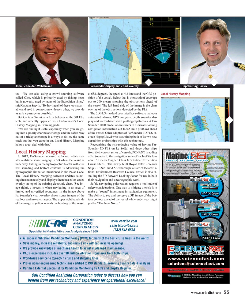
Farsounder display and chart overlay John Schneider, Wilhelmsen Captain Dag Saevik too. “We are also using a crowd-sourcing software at 63.8 degrees, the speed at 4.3 knots and the GPS po-
Local History Mapping called Olex, which is primarily used by ? shing boats sition of the vessel. Below that is the swath of coverage but is now also used by many of the Expedition ships,” out to 500 meters showing the obstructions ahead of said Captain Saevik. “By having all of these tools avail- the vessel. The left hand side of the image is the chart able and used in connection with each other, we provide overlay of the obstructions detected by the FLS.
as safe a passage as possible.” The 3D FLS standard user interface software includes
But Captain Saevik is a ? rm believer in the 3D FLS automated alarms, GPS compass, depth sounder dis- tech, and recently upgraded with FarSounder’s Local play and vector-based chart plotting capabilities. A Far-
History Mapping software upgrade. Sounder 1000 model allows users 3D forward-looking “We are ? nding it useful especially when you are go- navigation information out to 0.5 mile (1000m) ahead ing into a poorly charted anchorage and the safest way of the vessel. Other adopters of FarSounder 3D FLS in- out of a tricky anchorage is always to follow the same clude Hapag Lloyd who is out? tting both of its two new track out that you came in on. Local History Mapping expedition cruise ships with this technology.
helps a great deal with that.” Recognizing the risk-reducing value of having Far-
Sounder 3D FLS on Le Soléal and three other ships from their current series of vessels, PONANT is adding
Local History Mapping
In 2017, FarSounder released software, which cre- a FarSounder to the navigation suite of each of its four ates real-time sonar imagery in 3D while the vessel is new 131 meter long Ice Class 1C Certi? ed Expedition underway. Filling in the hydrographic blanks with cur- Cruise Ships. The newly built Royal Polar Research rent sounding and bottom contours is addressing the Ship RRS Sir David Attenborough, a state of the art Na- hydrographic limitation mentioned in the Polar Code. tional Environment Research Counsel vessel, is also in-
The Local History Mapping software updates sound- stalling the 3D Forward Looking Sonar for use in both ings instantaneously and displays them in a color-coded their navigation and oceanographic work. overlay on top of the existing electronic chart. (See im- Safely navigating polar waters requires a multitude of age right), a necessity when navigating in an area of safety considerations. One way to mitigate the risk is to limited and unveri? ed soundings. In the image above make a “sound” investment in navigation equipment.
FarSounder’s chart overlay shows sonar images of the The ability to see and preserve a 3D image of the bot- sea? oor and in-water targets. The upper right hand side tom contour ahead of the vessel while underway might of the image in yellow reveals the heading of the vessel just be “The New Norm.” www.cacvibe.com [email protected] (732) 542-5588 s
